Uttarakhand


Welcome to VisitMyUttarakhand.com
Your ultimate guide to the beauty and culture of Uttarakhand! Discover popular destinations, hidden gems, adventure activities, and serene retreats with us. Whether you seek trekking, spirituality, or relaxation, find tips, accommodations, cuisine highlights, and insider insights on our website. Join us in exploring Uttarakhand's landscapes, culture, and hospitality. Let VisitMyUttarakhand.com be your trusted companion in this Himalayan paradise. Start planning your adventure today!
Search Your Destination Here...
Plan your vacation, adventure & sports destinations in uttarakhand.
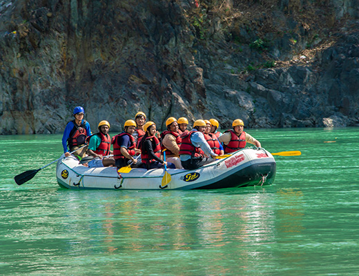
Uttarakhand is a premier adventure destination, offering activities like white-water rafting, skiing, trekking, and paragliding amidst stunning landscapes. Its rugged terrains, lush forests, and snow-capped peaks cater to both novice and seasoned thrill-seekers.
Explore Adventure & Sports Destinations In Uttarakhand

Valley-of-Flowers

Rajaji-National-Park

Naukuchiatal

Madhyamaheshwar

Hanuman-Chatti

Janki-Chatti
Pancheshwar
Khaliya-Top
Trekking Destinations In Uttarakhand
Embark on an unforgettable adventure in Uttarakhand, exploring the vibrant Valley of Flowers, mysterious Roopkund, and sacred trails to Kedarnath and Hemkund Sahib. Experience breathtaking Himalayan landscapes, rich biodiversity, and pristine natural beauty.
Explore Trekking Destinations In Uttarakhand

Kafni-Glacier-Trek
Dodital-dayara-Pass-Trek
Dayara-Bugyal-Trek
Tungnath-and-Chandrashila-Trek
Pindari-Glacier-Trek
Sunderghunga-Trek
Brahmatal-Trek
Kedarkantha-Trek
Rupin-Pass-Trek
Adi-Kailash
Roopkund-Trek
Khatling-Glacier
Char Dham Yatra Destinations In Uttarakhand
The Char Dham Yatra in Uttarakhand takes devotees to four sacred shrines—Yamunotri, Gangotri, Kedarnath, and Badrinath—against the breathtaking backdrop of the Himalayas. This pilgrimage combines deep spiritual significance with stunning natural beauty and rich cultural heritage.
Explore Char Dham Yatra Destinations In Uttarakhand

Wildlife & Nature Destinations In Uttarakhand
Uttarakhand is a haven for wildlife and nature enthusiasts, with national parks like Jim Corbett and Rajaji hosting tigers, elephants, and diverse species. Its serene valleys, dense forests, and high-altitude meadows offer stunning landscapes for safaris, bird watching, and nature treks, highlighting the region's commitment to conservation.
Explore Wildlife & Nature Destinations In Uttarakhand

Jim-Corbett-National-Park

Govind-Pashu-Vihar-Wildlife-Santuary
Pilgrimage Destinations In Uttarakhand
Uttarakhand, a revered pilgrimage destination, features key spiritual sites like Haridwar, Rishikesh, and the Char Dham Yatra, along with the significant Sikh shrine Hemkund Sahib. These sacred locations offer profound spiritual experiences set against stunning natural landscapes.
Explore Pilgrimage Destinations In Uttarakhand

Rudra-Prayag

Karnaprayag

Vivekananda-Ashram
Vishnuprayag
Kartik-Swami-Mandir
Hill Stations & Scenic Beauty Destinations In Uttarakhand
Uttarakhand, the "Land of the Gods," is renowned for its breathtaking hill stations like Mussoorie, Nainital, and Auli, each offering unique beauty and adventure. From colonial charm and serene lakes to snowy peaks and panoramic Himalayan views, it’s a paradise for nature enthusiasts and travelers.
Explore Hill Stations & Scenic Beauty Destinations In Uttarakhand

Cultural & Historical Destinations In Uttarakhand
Uttarakhand is rich in cultural and historical sites, from the spiritual hubs of Haridwar and Rishikesh to colonial-era Dehradun and picturesque hill stations like Mussoorie and Nainital. Almora, Bageshwar, and Pithoragarh offer ancient temples and heritage, while Kausani’s panoramic views and Gandhi’s Ashram add historical depth.
Explore Cultural & Historical Destinations In Uttarakhand

Uttarakhand's Districtwise Tour: A Comprehensive Guide
Discover top visiting places in almora.
Discover top visiting places in Bageshwar

Discover top visiting places in Chamoli

Discover top visiting places in Champawat

Discover top visiting places in Dehradun

Discover top visiting places in Haridwar

Discover top visiting places in Nainital

Discover top visiting places in Pauri Garhwal

Discover top visiting places in Pithoragarh

Discover top visiting places in Rudraprayag

Discover top visiting places in Tehri Garhwal

Discover top visiting places in Udham Singh Nagar

Discover top visiting places in Uttarkashi

Discover Beyond Boundaries
Your Uttarakhand Journey Starts From Here!
Featured Articles
Lambi dehar mines: story, history, and how to reach – your complete travel guide, rediscover peace at 7 serene spots in uttarakhand after monsoon, dhari devi temple uttarakhand: how to reach, timing, history, complete travel guide, latest articles.

Visit Chaukori Uttarakhand in 2024: How to Reach, Places to Visit, Things to do, Complete Travel Guide

How to Travel from Delhi to Almora: Options from Other Cities

Visit Khirsu, Uttarakhand in 2024: How to Reach, Places to Visit, Things to do, Complete Travel Guide

Panch Kedar Temples, Trek, History – Complete Travel Guide

How to Reach Dodital Lake: Trek, Distance and Travel Tips

How to Travel from Nainital to Ranikhet: Your Ultimate Guide to Distance, Ticket Prices, and Travel Tips

Quick & Easy Jhangora Ki Kheer Recipe for Sweet Cravings

How to Travel from Dehradun to Badrinath: Your Ultimate Guide to Distance, Ticket Prices, and Travel Tips
Visual stories.

We’re glad that you’re here
Welcome to Visit Uttarakhand, your premier resource for exploring the diverse and stunning landscapes of this Himalayan paradise. We are committed to providing you with all the information and inspiration you need for an unforgettable journey.
We promote tourism in Uttarakhand, covering destinations, temples, trip plans, hotels, adventure tours, and much more. Let us be your guide as you discover the magic and beauty of Uttarakhand.
- About The Land of Gods
- Culture & People
- Rivers & Lakes
- Flora & Fauna
- Mountains and Glaciers
- Key Destinations
- Activities in Uttarakhand
Chardham Yatra
- Accommodation
- Tourism Circuits in Uttarakhand
- Tourist Guides
- FAQs Trekking
- Distance Calculator
- Explore Outing (Mobile App)
- For Business
- Latest News
- Advertisement Films
- Video Library
- Image Gallery
- Press Release
- Uttarakhand Tourism Logo English
- Uttarakhand Tourism Logo Hindi
- Advertisements of Uttarakhand Tourism
- Market Research and Statistics
- Travel Trade
- Book your Homestay
- Register your Homestay
- Avail subsidy for Registration
- Past Programmes
- Register your interest

No front page content has been created yet.

Uttarakhand - Simply Heaven.
Nestled in the lap of the Himalayas, Uttarakhand is one of the most beautiful northern states of India that enthralls everyone with its spectacularly scenic landscapes. Charming hill stations juxtaposed against snow-capped peaks, quaint villages along winding mountain roads, serpentine rivers carving their way through hills, world renowned conservation parks like ‘Jim Corbett Tiger National Park’ and ‘Asan Wetland Conservation Reserve’, world heritage sites like ‘Valley of Flowers’ and ‘Nanda Devi Biosphere Reserve’, waterfalls hurtling down slopes and serene lakes shimmering amidst beautiful towns- that's Uttarakhand for you.
Explore Uttarakhand

Triyuginarayan

All Season- All Reason Tourism Destinations
Numerous sprawling parks speak of Uttarakhand's continuous efforts to conserve its natural ecosystem; its rich culture and religious heritage ensures that it remains on top of everyone's travel plan. It has been a favored choice for travelers from around the world, who visit this mighty land every year to attain salvation for a life transforming experience. Here you can easily satiate all your adventurous desires; be it flying like a bird, cruising through the strenuous rapids of the Ganges, trekking to some of the fascinating peaks, skiing through some of the picturesque slopes and enchanting destinations, enjoy the longest cable-car ride in India and much more. In short, Uttarakhand is a dream destination for all!

Events, Fairs and Festivals

Current Temperature
Chardham 2018 - tour packages.
Rishikesh- Kedarnath-Badrinath-Rishikesh 6D/6N
Haridwar- Kedarnath-Badrinath-Haridwar 6D/6N
Haridwar - Kedarnath - Badrinath 6D/6N
Rishikesh - Badrinath - Rishikesh 4D/4N

Plan Your Trip
- How to Reach
- Where to Stay
- Send Queries

- Digital Library
- Event Calendar
- Adopt a Heritage
Our Partners

Project Performance Management system
Departmental Info
- Awards & Honors
- CEO's Message
- Tenders/EOI
- Policy and Guidelines
- Inside Government
- Important Links
- UTDB Sitemap
- CM Dashboard-UTKARSH
Let's socialize
Plan your auspicious journey

Uttarakhand

- 3 Other destinations
- 4 Understand
- 7 Get around
- 9.1 Trekking
- 12 Stay safe
<a href=\"https://tools.wmflabs.org/wikivoyage/w/poi2gpx.php?print=gpx&lang=en&name=Uttarakhand\" title=\"Download GPX file for this article\" data-parsoid=\"{}\"><img alt=\"Download GPX file for this article\" resource=\"./File:GPX_Document_rev3-20x20.png\" src=\"//upload.wikimedia.org/wikipedia/commons/f/f7/GPX_Document_rev3-20x20.png\" decoding=\"async\" data-file-width=\"20\" data-file-height=\"20\" data-file-type=\"bitmap\" height=\"20\" width=\"20\" class=\"mw-file-element\" data-parsoid='{\"a\":{\"resource\":\"./File:GPX_Document_rev3-20x20.png\",\"height\":\"20\",\"width\":\"20\"},\"sa\":{\"resource\":\"File:GPX Document rev3-20x20.png\"}}'/></a></span>"}'/>
Uttarakhand (Hindi: उत्तराखण्ड Uttarākhaṇḍ ), until 2007 known as Uttaranchal , is a stunningly beautiful state in the Himalayan North of India .

Uttarakhand has two large divisions, each with its own culture and language.
Here are nine of the most notable cities.
- 30.32295 78.03168 1 NOT EXISTING LISTING IMAGE Dehradun — the capital, called the "Oxford of India" for its boarding schools
- 29.62 79.67 2 Almora — a hill station
- 29.956 78.17 3 Haridwar — a holy city on the Ganges and one of the sites of Kumbh Mela, the world's largest festival
- 29.4722 79.6479 4 NOT EXISTING LISTING IMAGE Mukteshwar — a small town made famous by Jim Corbett who penned the novel "The Man Eaters of Kumaon"
- 30.45 78.08 5 Mussoorie — famous hill station near Dehradun known for its scenic beauty and panoramic views
- 29.38 79.45 6 Nainital — picturesque hill station in the Himalayan foothills known for its 150+ year old schools
- 29.5833 80.2167 7 Pithoragarh — a city in Uttarakhand that is close to the borders with China (Tibet) and Nepal
- 30.08693 78.26761 8 Rishikesh — the yoga capital of the world
Other destinations

- 30.94942 77.7478 1 Auli — ski resort
- 30.74242 79.49603 2 Badrinath — temple of Vishnu
- 30.7 77.8667 3 Chakrata — picturesque, less frequented hill station
- 29.39741 79.12725 4 Corbett National Park — oldest national park of India
- 29.1425 79.08772 5 Dunagiri — nature retreat
- 30.98 78.93 6 Gangotri — source of the holy Ganges river
- 30.73 79.07 7 Kedarnath — temple of Shiva
- 30.0715 80.2373 8 Munsyari — End of the Indian road and start of trekking routes into the montane wilderness
- 30.99687 78.46165 9 Yamunotri — source of the Yamuna River
Uttarakhand, which is in the Himalayan region, is one of the most picturesque states in the country and has tourist destinations that range from hill stations to popular towns to pilgrim destinations.
The local languages are Kumaoni and Garhwali , but everyone also speaks Hindi . English is not so common, but well-understood and spoken in some parts.
There are many ways to enter Uttarakhand. If you are interested in seeing the Garhwal region you can enter through either Haridwar or Kotdwar. Haridwar is the more popular entrance. For both options there are regular bus and train services available from New Delhi. Entry in Kumaon is through Ramnagar, Haldwani or Tanakpur. Major entry points of the state include:
- If entering from Dehradun , you can head towards Mussoorie , Chakrata , Barkot and Yamunotri .
- If entering from Haridwar , you can head towards Rishikesh , Tehri , Uttarkashi and Gangotri .
- If entering from Kotdwar , you can head towards Lansdowne , Satpuli, Pauri, Srinagar, Rudraprayag and Kedarnath .
- If entering from Ramnagar, you can head towards Ranikhet , Chaukhutia, Karnprayag, Joshimath and Badrinath .
- If entering from Haldwani, you can head towards Nainital , Almora , Kausani , Bageshwar , Chaukori and Munsyari .
- If entering from Tanakpur, you can head towards Champawat, Lohaghat, Pithoragarh , Askot, Jauljibi and Dharchula.
Public transport mainly consists of buses and shared jeeps that ply the major north-south pilgrimage routes during the day. Travelling between or away from these routes may require a long wait, hitchhiking, or hiring a private vehicle. In the higher mountains, most drivers are friendly and will take extra passengers if they have empty seats, often in exchange for a small payment (similar to the bus fare).
Rockfalls are frequent during monsoon season, and can delay travel for several hours. The main north-south routes are also the main access points for the Indian Army to its border with China, so rockfalls tend to be cleared quickly (i.e. within the same day) on these roads. Rockfalls on minor roads may stop traffic for days or sometimes even weeks.
Uttarakhand is an increasingly popular destination for motorcycling and cycling, and walking is an option in pilgrimage season, when thousands of pilgrims walk the major pilgrimage routes.
Private taxis and jeeps are available in most towns.
Nainital , Mussoorie and Ranikhet though it's better to treat these slightly overcrowded, touristy 'hill stations' as base camps to explore lots of other hidden jewels further afield in Uttarakhand. In Garhwal , Pauri and Gwaldam there are very peaceful & scenic places. In the Kumaon region, if you are near Almora and want to stay in a secluded area, try Peora or Mukteshwar .
- Jim Corbett National Park -The oldest national park in India, this wildlife sanctuary has been a hot-spot for plenty of nature lovers. The humble abode of Sambar deer, elephant, golden jackal and many others, the park has surprises in store for all. It is inhabited by at least 300+ tigers, 600 species of birds, 50 mammals and 25 reptile species. From abundant flora and fauna to green foliage, there is beauty all around.
- Rajaji National Park - Rajaji National park always attracts to wildlife enthusiasts and nature lovers. This place is located around 248 km from Delhi and around 6 km from Haridwar. This park remains open from November to June for the tourists.
- Badrinath Temple - This beautiful temple is located near to Alaknanda River, at an altitude of 3133 meters above from the sea level. This temple is dedicated to the Lord Vishnu.
- Bhowali - Bhowali is situated at a distance of 12 km, from Nainital, at an altitude of 1,706 m, from the level of sea. This place provides a panoramic view of the nature. This place if famous for its panoramic view as well as hill fruit mart, which was established in 1912.
- Dehradun - Dehradun is the capital city of Uttarakhand. This is one of the oldest cities of India, located in the Himalayas. This city is also termed as the “Oxford of India”, as it is best known educational centres of India.
- Dunagiri - pristine and tranquil ancient forests.
Uttarakhand is a great place for trekking. At the lower levels, there are forests and wildlife. At the upper reaches, you go past the tree line to snow clad mountains. There are many trip designs which can be conceived of, but there are perhaps around 20 trips which are the most popular. See also: Leave-no-trace camping and Wilderness backpacking
- Roopkund Trek (Bedni Bugyal, Chamoli District) - one of the most popular treks. Roopkund, also known as Mystery Lake, is a clear water Himalayan lake. Roopkund starts from Debal. This beautiful lake is surrounded by majestic Himalayan peaks covered with snow and glaciers. Generally, trekkers and adventurers travel to Lohajung or Wan by road. From there, they climb a hillock at Wan and reach Ran ki Dhar, where a flat area allows for overnight camping. If the sky is clear, one can see Trishul Parvat from Bedini Bugyal. The next camping spot is at Bedini Bugyal, which is 12–13 km from Wan. There is a huge grazing ground for mules, horses, and sheep. One can see many Himalayan peaks from Bedini Bugyal bridge. Trekkers then go up to Bhagwabasa, which is 10–11 km from Bedini Bugyal. The weather at Bhagwabasa is hostile most of the year. From Bhagwabasa, trekkers either go to Roopkund and return, or go to Shila Samundra (Ocean of Stones) via Junargalli Col Pass, which is just above the lake, and then proceed to Homkund . Another trekking route starts from Mundoli, near Tharali, which is accessible from Haridwar and Rishikesh. Kathgodam - Ranikhet - Garur - Gwaldam - Debal (1220 m) - Bagrigad (1890 m) - Mundoli village - Lohajung pass - Wan village (2590 m) - Bedni Bugyal (3660 m) - Kalu Vinayak - Baghubasa - Roopkund. Kathgodam is the only place connected by rail.
- Tungnath- Chandrashila Trek, Chopta - Chandrashila commands the most beautiful view of the Himalayas in the whole region, especially Chaukhamba & Nanda Devi. There's one of the Panch Kedars - Tungnath's temple - the highest temple of Shiva. There are camping fees for the location as it comes under Kedarnath Wildlife Sanctuary. Take your own trekking equipment. It’s better to rent from Delhi. You can pitch & stay anywhere you want along the trek route.
- Deoriatal Trek, Chopta - Deoriatal Trek is one of the famous trekking destinations in Uttarakhand. One can drive up to the Sari village near Ukhimath, from where it is a short 4 km walk to the lake. Trekking can be done for entire year in Deoriatal.
- Gangotri Glacier Trek - Tapovan (meditation ground of Gods), Gaumukh (source of Ganga) & Shivling Mountain.
- Har ki doon - very scenic trek, near to Swargrohini peak, from where Pandavas went to the heaven.
- Kafni glacier trek
- Kalindni Pass Trek - Gangotri to Badrinath.
- Khatling Glacier - near Gangotri.
- Kuari Pass Trek - near Auli, quite popular with foreign tourists
- Madmaheshwar Trek - near Ukhimath, Rudraprayag - one of the most beautiful treks leading to a Panch Kedar, it's at the base of Chaukhamba Peak (7,000 m/23,950 ft).
- Milam glacier trek
- Panwali Bugyal Trek, Tehri District - it leads to Triguninarayan, a place where the eternal flame of Shiva & Sati's (Parvati's previous incarnation) marriage is still kindling.
- Pindari glacier trip
- Satopanth Swargarohini Trek - near Badrinath, one of the most pristine treks. Satopanth tal is a lake at an altitude of 4,600 m.
- Sunder dhunga trek
- Thailisan - Binsar Trek in Pauri, an uplifting trek, providing panoramic view of Himalayas.
- Trekking inside Nanda Devi Sanctuary
- Valley of Flowers Trek - near Badrinath - the most beautiful valley.
- Nanda Devi National Park Trek- Covers Lata Karak, Saini Kharak & Jindidhar on the periphery of the corezone. The park is open for trekking and camping till Dharanshi inside the core zone.
Kumaoni food is very simple but very nutritious and completely suits the hard environment of the Himalayas. Pulses like gehet are fashioned into different preparations like ras-bhaat, chains, faanda and thatwaani – all are unique preparations from the same pulse. Jholi or curry seasoned with curd. Chudkan
- Aaloo gutuk and Pinalu Gutuk are fried potatoes or pinalu, seasoned with spices.
- Bal Mithai is a brown chocolate-like fudge, made with roasted khoya, coated with white sugar balls.
- Bhatt ki Churkani is a soup like preparation of bhatt pulses eaten with rice.
- Chains is a preparation of whole urad which are first roasted then ground and then seasoned into a soup.
- Dubka is a simple dish made from various lentils, which are ground and made into a curry-like dish with a few local spices available in the Kumaon hills like jamboo and jakhiya. It's usually made in an iron wok and eaten with rice.
- Jholi is a curry seasoned with curd and curry leaves.
- Kaapa is a dish prepared with spinach leaves crushed into a paste and cooked with other condiments.
- Saag is a fried dish of green vegetables. Can be made from any of the various green vegetables like palak (spinach), lai, methi (fenugreek leaves) and so on.
The types of food here include Garhwali, Indian, Chinese and Tibetan. In the tourists centers such as Badrinath, Gujarati, and Marwari, other regional cuisines are available for the hordes of pilgrims that descend on the holy sites every summer.

Uttarakhand has high excise taxes on beer and alcohol: a bottle of beer can cost ₹150-₹250, nearly double the price of some other states in India. Quite a few holy towns including Haridwar and Rishikesh are officially dry. Cannabis is illegal, but widely used anyway.
The roads are a bit tricky, and taxi rides in the hills may appear dangerous, but otherwise Uttarakhand is a pretty safe place for tourists. However, tourists are known to encounter problems in the urban centres and the plains districts such as Haridwar.
One may take up one of the trekking tours to have a walk in Chopta, Tungnath, Deoria Taal and Chandrasheela. Or, simply dive into the natural garden of Buransh - a destination considered to be the Switzerland of India.
- Has custom banner
- Has mapframe
- Has map markers
- Has Geo parameter
- Himalayan North
- All destination articles
- Outline regions
- Outline articles
- Region articles
- Pages with maps
Navigation menu
- Uttarakhand Tourism

- Search Please fill out this field.
- Newsletters
- Destinations
- Uttarakhand
12 Unforgettable Tourist Places to Visit in Uttarakhand
What to See and Do in the Land of Natural Beauty
:max_bytes(150000):strip_icc():format(webp)/10947453_10153084623948270_8191342691038933499_o-591d1e8d3df78cf5fa731909.jpg "uttarakhand tourism org")
Uttarakhand, bordered by Nepal and Tibet, and shadowed by towering Himalayan peaks, is full of unspoiled natural beauty. It's divided into two regions—Garhwal in the north, and Kumaon in the south. Ancient holy places, mountains, forests and valleys, and an abundance of trekking options are some of the attractions that make travel to Uttarakhand worthwhile. Check out these top tourist places in Uttarakhand for inspiration.
Uttarakhand is also an excellent place to get off the beaten track. If you're looking for fresh air and tranquility, you'll love some of these boutique Himalayan getaways .
Jim Corbett National Park
One of India's most popular national parks , Jim Corbett National Park is named after hunter-turned-conservationist Jim Corbett. It has dense forest and an array of wildlife, although tiger sightings aren't as common as some other places in India. The park can be explored by jeep or elephant safaris, which take place daily in the early mornings and afternoons. The Dhikala zone of the park is the most panoramic, with stunning valley views. It offers the best chance of animal sightings (which are unfortunately sometimes disappointing). If you're lucky, you might spot wild elephants.
- Location: About five hours drive northeast of Delhi.
- Check Out Current Corbett Hotel Deals on Tripadvisor and Save
Ancient Haridwar (the "Gateway to God") is one of the seven holiest places in India, and one of the oldest living cities. Located at the foothills of the Himalayas in Uttarakhand, it's particularly popular with Hindu pilgrims who come to take a dip in the holy waters of the fast flowing Ganges River and wash away their sins. The evening Ganga Aarti holds a special appeal.
- Check Out Current Haridwar Hotel Deals on Tripadvisor and Save
Rishikesh, located not far from Haridwar, is as popular with western spiritual seekers as Haridwar is with Hindu pilgrims. Known as the birthplace of yoga, people flock there to meditate, do yoga, and learn about other aspects of Hinduism in the various ashrams and yoga institutes. Despite the growing number of visitors, the town's lanes and alleys retain an old-world charm. It remains a wonderful place to relax and unwind among nature.
- Location: 40 minutes drive northeast of Haridwar.
- Check Out Current Rishikesh Hotel Deals on Tripadvisor and Save
The hill settlement of Nainital, in the Kumaon region of Uttarakhand, was a popular summer retreat for the British during the time they ruled India. It features emerald colored Nainital (Naini) Lake and an action-filled strip called The Mall, lined with restaurants, shops, hotels, and markets. Enjoy one of the many forest walks, explore the surrounding area on horseback, or relax on a boat in the lake. This destination gets very crowded during summers, especially on weekends, due to its proximity to Delhi. Around Nainital, you'll find Jeolikote, Bhimtal, Ramgarh and Mukteshwar which are all less developed and quieter places to stay.
- Location: About 6.5 hours drive east of Delhi.
- Check Out Current Nainital Hotel Deals on Tripadvisor and Save
Mussoorie is another popular weekend destination for north Indians, as well as honeymooners. One of the main reasons for this is because it has a lot of facilities developed especially for tourists. Take a cable car to Gun Hill, enjoy a beautiful nature walk along Camel's Back Road, have a picnic at Kempty Falls, or ride a horse up to Lal Tibba (the highest peak in Mussoorie). Mussoorie also offers a superb view of the Himalayas. If you're looking for a quieter alternative nearby, check out Landour.
- Location: About six hours drive north of Delhi and an hour from Dehradun (Uttarakhand's capital). IRCTC offers a convenient two-night weekend rail tour package from Delhi to Mussoorie.
- Check Out Current Mussoorie Hotel Deals on Tripadvisor and Save
Almora, now the capital of the Kumaon region, was established as the summer capital of Chand kings in 1560. It attracts its share of foreigners who head to nearby Kasar Devi Temple, where Swami Vivekananda meditated. There are some chilled out places to stay in the area, such as Kasar Rainbow Resort and Mohan's Binsar Retreat, as well as inexpensive guesthouses with private cottages just outside Almora town. Around Almora, you'll find the Binsar Wildlife Sanctuary, Kausani (where Gandhi spent time writing his Bhagavad Gita treatise), Ranikhet and the Jageshwar temple complex.
- Location: About nine hours drive northeast of Delhi.
- Check Out Current Almora Hotel Deals on Tripadvisor and Save
Valley of Flowers National Park
The remarkable landscape of The Valley of Flowers National Park in the Garhwal region comes alive with the monsoon rain. This high-altitude Himalayan valley has around 300 different varieties of alpine flowers, which appear as a bright carpet of color against a mountainous snow-capped background. It's a popular trekking destination, open from the start of June until the end of October.
- Location: About 15 hours drive northeast of Delhi, plus a trek.
Char Dham Yatra
Located high up in the Garhwal region of Uttarakhand, the Char Dham (four temples) mark the spiritual source of four holy rivers: the Yamuna (at Yamunotri), the Ganges (at Gangotri), the Mandakini (at Kedarnath), and the Alaknanda (at Badrinath ). Hindus consider a pilgrimage to the Char Dham to be very auspicious. Not only is it believed to wash away all sins, but it will also ensure release from the cycle of birth and death.
Srijan96/Wikimedia Commons/CC BY-SA 4.0
Uttarakhand even has a skiing destination! Auli lies on the way to Badrinath and has a three-kilometer long slope, gondola, chairlift, and Poma ski lift. For skiing, conditions are best from the last week of January to the first week of March. However, it's dependent on good snowfall, which is variable. If you're into trekking, the Kuari Pass trailhead is at Auli. This trek, which passes through Nanda Devi National Park, is one of the state's best and most accessible. Thrillophilia offers six-day guided trips from Haridwar . There are many other hiking trails around too.
Accommodation options in Auli are scarce but Devi Darshan Lodge is recommended if you don't stay at the popular government-run Garhwal Mandal Vikas Nigam Hotel (which offers ski programs). Alternatively, the Himalayan Abode Homestay near Joshimath is excellent, and the host is a skiing and snowboarding champion and coach. Another good option is Himalayan Eco Lodge .
- Location: About 13 hours drive northeast of Delhi, near Joshimath.
Indranil Dutta/Getty Images
Magical Munsiyari, a small town surrounded by towering mountains in the Pithoragarh district of Uttarakhand, is paradise for mountaineers and trekkers. Blazing sunsets create a stunning backdrop of color-stained peaks there. However, the hiking and trekking routes are the biggest draws. Munsiyari is the base for the challenging nine-day Milam Glacier Trek , and the much easier two- to three-hour trek to Khalia Top is another attraction. The Tribal Heritage Museum, filled with artifacts from Munsiyari's trade with Tibet on the ancient salt route, is also worth seeing. Milam Inn , albeit basic, is the best place to stay in Munsiyari and it offers fabulous mountain views from the guest rooms.
- Location: About 16 hours drive northeast of Delhi.
Varun Shiv Kapur/Flickr/CC BY 2.0
Chopta Valley View Point
Not to be confused with the Chopta Valley in Sikkim, Chopta lies between Kedarnath and Badrinath in the Garhwal region of Uttarakhand, at the entry to Kedarnath Wildlife Sanctuary. It attracts travelers who want to enjoy the great outdoors away from the crowds and development. Chopta is the starting point for treks to Tungnath temple (open from June to September) and Chandrashila summit. It's a short, yet scenic, moderate trek that can be completed in a day. Notably, the temple is the world's highest Shiva temple. Thrillophilia offers four-day guided trips from Haridwar.
- Location: About 10 hours drive northeast of Delhi, via Rishikesh.
It's likely that you've never heard of Kalap, a tiny remote village that's only accessible by foot, 7,500 feet above sea level in the upper Garhwal region of Uttarakhand. That's because it's totally off the tourist map. A responsible tourism project was established there in 2013 to help improve the livelihoods of the villagers. Kalap is an outstanding place to get away from it all and experience the simplicity of village life or go trekking along trails followed by nomadic shepherds.
- Location: About six hours north of Dehradun in Uttarakhand.
Related Articles
More related articles.
Uttarakhand Tourism
Showing results for: array.
- Uttarakhand
- Uttarakhand History
- Chipko Movement
- Uttarakhand Map
- HillStations
- Almora - Town of Temples
- Bageshwar - Land of Lions
- Chamoli - Heaven on Earth
- Champawat - Nature's Paradise
- Pithoragarh - Mini Kashmir of India
- Pauri Garhwal - Quite and Peaceful
- Tehri Garhwal - Perfect Getaway
- Rudraprayag - Beautiful
- Haridwar - The Gateway of God
- Nainital - The Lake District
- Dehradun - The Capital City
- Udham Singh Nagar - Food Bank
- Uttarkashi - Land of Lord Shiva
Uttarakhand Tour Packages
- Rishikesh Rafting Tour Packages
- Chardham Tour Packages
- Winter Chardham Tour Packages
- Trekking in Uttarakhand
- Char Dham Yatra
- Char Dham with Helicopter
- Gomukh, Gaumukh
- Panch Prayag Yatra
- Panch Kedar Yatra
- Do Dham Yatra
- Do Dham with Helicopter
- Hotels in Dehradun
- Hotels in Uttarkashi
- Hotels in Almora
- Hotels in Nainital
- Hotels in Chamoli
- Hotels in Haridwar
- Hotels in Bageshwar
- Hotels in Champawat
- Hotels in Pauri Garhwal
- Hotels in Tehri Garhwal
- Hotels in Pithoragarh
- Hotels in Rudraprayag
- Hotels in UdhamSinghNagar
- Haridwar To Delhi
- Delhi to Haridwar
- Rishikesh To Delhi
- Delhi to Rishikesh
- Dehradun To Delhi
- Delhi to Dehradun
- Dehradun Airport Jolly Grant Taxi
- Assan barrage
- Chilla National Park
- Tapovan - Land of Lord Shiva
- Binsar Wildlife Sanctuary
- Nandadevi National Wildlife Sanctuary
- Har Ki Dun Trek
- Roopkund Trek
- Kauri Pass Trek
- Dodital Trek
- Valley of Flowers Trek
- Gomukh Tapovan Trek

Uttarakhand or Uttaranchal was carved out of 13 districts of Uttar Pardesh in 9th of Nov2000. It became the 27th state of the Indian Union and Dehradun was made the state capital. The initial name Uttarakhand was renamed to Uttaranchal and finally again changed to Uttarakhand in 2006.
Uttarakhand is home to the holiest rivers the Ganga and Yamuna and the mightiest of the mountains the Himalayas. The Char Dham, Haridwar and Rishikesh are considered as the holiest place in the world. It is surrounded by huge mountains and around 70% of the state land is situated in the hilly region.
This exceptionally beautiful state is believed to be created by gods for themselves as their second home hence it is also called as the Abode of Gods.
Complete best encyclopedia on Uttarakhand - Tourism - Hotels - CharDham Yatra - Mussoorie and more..
Uttarakhand tourist destinations.

Char Dham Yatra starting @ र 16500 per person.
Char dham yatra guide.
The Char Dham Yatra is an yatra of holy spiritual nature for the hindus. The holy Uttarakhand yatra in the garhwal make it one of the most unforgettable journey in the lifetime.
Find more deals and discounts on all Budget, Standard and Deluxe Char Dham Yatra Packages
We provide tickets to Kedarnath at the best possible rates guaranteed.

Uttarakhand Tourism Map
Uttarakhand is a one of the most beautiful states of India and an approx 10million tourist come here each year. Check out the important tourist places to visit here in Uttarakhand.
Find more deals and discounts on all Budget, Standard and Deluxe Adi Kailash Yatra Packages
Adi Kailash Yatra Guide
The Adi Kailash Yatra is one of the most revered yatra for the hindus. This yatra usually begins in the month of
उत्तराखंड , Uttarakhand or Uttaranchal God's own land is a top tourist destination. We bring Uttarakhand Tourism Latest Detailed Information Online on Char Dham, Kedarnath, Badrinath, Yamunotri, Gangotri, Rishikesh and Uttarakhand district such as Haridwar, Dehradun, Nainital, Almora, Chamoli, Tehri Garhwal, Pauri Garhwal, Bageshwar, Rudraprayag and Champawat online to millions of viewers round the world.
Uttarakhand is surrounded with high snow covered peaks, natural beautiful surroundings, major pilgrims centres and beautiful valleys, jungle safaris, adventure sports, mighty holy rivers and wellness resorts a complete package for the tourists in a single platter.
There are around 152 important tourist places to visit here in Uttarakhand. Some of them are are Mussoorie the queen of hills, Nainital the lake district, Almora the switzerland of india, Ranikhet the queen's fields ,Bageshwar the land of the lion, Chamoli and Uttarkashi and many more..
The char - Dhams - Gangotri, Yamunotri, Kedarnath and Badrinath is well known with around lakhs of pilgrims visiting the holy sites every year. Haridwar one of the seven scared cities in India lies in the foothills of Shivalik ranges. Hemkund Sahib, Lokpal, Nanakmatta, Meetha Reetha Sahib and Piran kaliyar very sacred and holy place visited by lakhs of pilgrims from all over the world.
Uttarakhand is also a paradise for adventure sport tourists, they may choose mountaineering in Bhagirathi, Chowkhamba, Pindari , Sahastrataal, Milam, Kafni, Khatling and Gaumukh. The tourists can enjoy the beautiful shiny peaks fully covered with snow, lush green jungles, alpine meadows, glaciers and scenic surroundings along with the excitement of the adventure sports.
In Uttarakhand, tourism for yatra CHARDHAM, DODHAM and for trekking and skiing, tourists may choose from Auli , Dayara bugyal , Munsyari and Mundali. Water Sports like Rafting , Bungee Jumping , Boating, Angling, Aero Sports and Hand Gliding and Paragliding in Pithoragarh, Nainital, Rishikesh Yoga Capital of the world and Pauri Garhwal.
Uttarakhand is rich in exotic flora and fauna and is well known for eco tourism and wildlife tourism. Some of the well known national park sanctuaries are The Corbett, The Rajaji National Park and the Govind Wildlife Sanctuary.

The Mussoorie Winter Line phenomenon is unique in the whole world. Mussoorie the queen of hills is a well known hill station around the world..Read more on Mussoorie
- | 34 hotels
- | 11 sightseeing |

Nainital the lake district of Uttarakhand is also one of the cleanest cities. It is a well known tourist place and well known for adventure sports..Find more of Nainital
- | 41 hotels
- | 12 sightseeing |

Haridwar Uttarakhand is one of the biggest pilgrimage sites and the gateway to the char dham yatra. Find more Information on Haridwar
- | 37 hotels

Rishikesh Uttarakhand is the yoga capital of the world, pilgrimage site and well known for adventure sports. Find more on this holy city on Rishikesh
- | 18 hotels |

This beautiful picnic spot with perfect climate and serene landscapes make it a perfect holiday getaway. Just 25kms from Mussoorie .. Read more this hillstation Dhanaulti
- | 9 hotels |

Lansdowne is one of the most peaceful and quietest hill - station of Uttarakhand. It is surrounded by thick pine and deodar forest .. Read more about Lansdowne
- | 12 hotels |

Corbett National Park
Enjoying the wildlife atop ur very own elephant makes you feel like the King of Uttarakhand. Enjoy jungle safari's in Corbett Wildlife Sanctuary and much more...Corbett National Park
- | 15 hotels |
Please Contact us for your Queries and Quotation
Drop us your Travel Query and we will get back to you ! Get Best Rates Guaranteed !!
NOTE: Your travel queries are passed on to our travel helpdesk who will contact you with a travel offer as per your requirements..Prices vary depending on group size, extra services, transportation & hotels offered to client. Kindly fill the form above to get the exact quote.
Geography and Tourism
Uttarakhand is divided into 2 regions the Garhwal and the Kumaon. Both the regions are equally beautiful and have a surrounded by the majestic mountain peaks of Bhagirathi, Chowkhamba, Pindari, Sahastrataal, Milam, Nanda Devi, Gangotri, Kedarnath and Jogin Group and many more.
The Garhwal region has around 7 districts while the kumaon region is made up of 6 districts. The Nanda devi mountain is the natural divide among the two regions. The districts in the Garhwal region are Dehradun, Haridwar, Tehri Garhwal,Pauri Garhwal, Uttarkashi, Chamoli and Rudraprayag while the Kumaon region consists of Almora, Bageshwar, Champawat, Nainital,Pithoragarh and UdhamsinghNagar. It is further divided into 49 sub-divisions and 95 development blocks, 15,638 inhabited villages and 86 urban settlements in the state
Uttarakhand with a total area of around 53,483 sqkms has a total forest area of around 35,651 sqkms with majority of them are Oak and Pine forests.
The Yamuna and the Ganges are the two biggest rivers of Uttarakhand and also the most important. They are also one of the biggest rivers in India. The other important rivers passing through the state are the Sarayu, Alaknanda, Bhagirathi, Dhauliganga, Ramganga, Tons and Saraswati. These holy rivers give form to most of the important holy places such as the prayas, Haridwar and Rishikesh and provide a lifeline for almost a 5 million of people across 5 states in India.
Garhwali and Kumaoni are the two main regional languages, whereas Hindi is the most widely spoken language.
Culture Cuisines for Tourists
The people here celebrate all major festivals such as Holi, Diwali, Navratri. Some of the festivals related to Uttarakhand are Ghee Sankrant, Harela and Bhitauli. The people enjoy enacting the great hindu epics of Mahabharata and Ramayana during the diwali festivals. The Pandav Nitya and the Jagars are one of the highlights of the festivals.
Uttarakhand is a poor state with agriculture as the primary occupation. The food also is very simple in the hills but as the people say that the water here is magical which increase the taste of any food tenfold. Here the use of spices and tomatoes is very minimal. Madua ( Buck wheat ) - Koda , Rajma, locally grown green vegetables, fish form their staple diet. Some of the famous cuisines of Uttarakhand are Tuasu, Kaplu, Jholi, Phaanu, Thechwani, Swala, Jhangora and Desserts are Arsa ,Methubhat, Gulgula, Jhangora ki kheer and Prasad ( mix of wheat flour and ghee ) . It is believed that a stay of 6months in garhwal can cure a man of obesity.
Music and dance form a essential part of festivals of the people of Uttarakhand. Some of the most common folk songs are Chhopati, Chounphula, Jhumeila and Basanti. Mangal is another popular folk song which is sung during the marriage ceremony by girls to tease the bridegroom and his friends. Langvir Nritya, Barada Nati and Pandav Nritya are some of the traditional folk dances of Uttarakhand.
How to Reach Uttarakhand
Jolly Grant airport is a newly developed domestic airport of Uttarakhand. There are direct flights from Mumbai, Kolkatta, Hyderabad, Bangalore, Jaipur and Lucknow. Lot of indirect flight from Delhi also reach Jollygrant on a daily basis.
Haridwar Junction, Dehradun and Kathgodham are major railway station in Uttarakhand. It is well connected to all major cities in India.
Dehradun ISBT and Haridwar are major state bus terminals and have good road connectivity with some of the nearby major cities such as Jaipur, Shimla, Haryana, Punjab and Delhi.
CharDham Yatra

Uttarakhand Wild and Adventure

Uttarakhand is a land of extremes, here you can get yourself lost in the quite wilderness of the Himalayas or on the other side indulge yourself in madness of extreme sports such as white water rafting, bungee jumping, skiing. Trekking on the mighty Himalayan glaciers is also on the cards which will spoil you for choices during your vacations..
Uttarakhand Unexplored
Latest reviews on uttarakhand tourism, raghunathji review.

Bharatbhai Review

- Capital City
- Lansdowne Hotel
- Mussoorie Hotel
- Kedarnath Hotel
- Badrinath Hotel
- Yamunotri Hotel
- Rishikesh Hotel
- Joshimath Hotel
- Gangotri Hotels
- Kanatal Hotels
- Dhanaulti Hotels
- Auli Hotels
Tourist Spots
- Chardham Yatra
- Chardham News
- Chardham Route
- Chardham Map
- Chardham Tours
- Chardham Faq
- Tehri Garhwal
- Pauri Garhwal
- Rudraprayag
- Pithoragarh
- Udhamsingh Nagar
Taxi Cab Rental
- Uttarakhand Taxi
- Chardham Taxi
Yatra Dhams
- Do Dham by Helicopter
- Chardham by Helicopter
This site is not an Official website of the Govt of Uttarakhand. This site is owned and managed by VIRAT TOURISM - Dehradun. We have no other branches in India. All rights reserved (c) 2018 - 2025
- Screen Reader
- Skip to main content
- Text Size A
- Language: English
- Case Studies
- EXIM Procedure
Media & Events
- Image Gallery
- Media Coverage
Other Links
- GI of India
- Experience India
- Indian Trend Fair 2022
- India Organic Biofach 2022
- Gulfood Dubai 2023
Uttarakhand
Uttarakhand is the "yoga capital of the world" and is the leading producer of pear, peach, plum, and apricot..

Uttarakhand State Report
Introduction.
Uttarakhand is located in the foothills of the Himalayan mountain range. The state shares borders with China (Tibet) in the north, Nepal in the east, and inter-state boundaries with Himachal Pradesh in the west and northwest and Uttar Pradesh in the south. It has almost all agro-geo climatic zones, which provide commercial opportunities for floriculture and horticulture. The state is home to more than 175 species of rare medicinal, aromatic & herbal plants. The state has proximity to the national capital, Delhi, a leading market of the country and excellent connectivity with neighboring states. Uttarakhand has abundant natural resources due to hills and forests. Its agro-climatic conditions support horticulture-based industries. The vast water resources available in the state are also favorable for hydropower.
Uttarakhand is one of the fastest growing states in India, thanks to the massive growth in capital investment arising from conducive industrial policy and generous tax benefits.
The state offers a wide range of benefits in terms of interest incentives, financial assistance, subsidies, and concessions. Uttarakhand has a robust social and industrial infrastructure, virtual connectivity with over 39,000 km of road network, two domestic airports, 345.23 km of rail routes.
As of May 2022 (Upto December), 30 Industrial Entrepreneurs Memorandums (IEMs) worth US$ 209.30 million) have been filed in Uttarakhand.
Uttarakhand Tourism
The presence of several hill stations, wildlife parks, pilgrimage places and trekking routes make Uttarakhand an attractive tourist destination. The tourism sector is accepted as a growth driver for inclusive social economic progress through its forward and backward linkages and the ability to create employment in the economy. The state is considering development of spiritual and religious theme-based circuits for tourism. Under the Swadesh Darshan scheme of the central government, Uttarakhand is a site for eco-tourism. Other themes may involve treks/hikes/tours to view famous Himalayan peaks or treks along the course of the Ganga river, places of culinary interest, or villages where communities maintain traditional lifestyles that tourists may find interesting. The state witnessed surge in tourist arrivals, with 7 crore tourists arriving in 2023, it is expected to grow by 20% to 8.4 crore in 2024.
The economy of Uttarakhand
At current prices, Uttarakhand’s GSDP is projected to be Rs. 3.94 trillion (US$ 47.34 billion) in FY24. Between 2018-19 and 2024-25, GSDP of the state is estimated to increase at a CAGR of 8.86%. According to the Department for Promotion of Industry and Internal Trade (DPIIT), between October 2019-March 2024, FDI inflow in Uttarakhand stood at US$ 187 million. In FY24, the total exports from the state stood at US$ 1.80 billion.
Industries in Uttarakhand
Uttarakhand is one of the fastest growing states in India, thanks to the massive growth in capital investment arising from conducive industrial policy and generous tax benefits. The MSME sector plays a crucial role in the economic and social development of the state as this sector is the nursery of entrepreneurship. The government has placed a special mandate in its Vision 2030 strategy to develop the MSME sector. In the State Budget 2024-25, crop husbandry has been allocated Rs. 644 crore (US$ 77.25 million) which includes schemes such as National Mission for Natural Farming and PMKSY. Additionally, Rs. 157 crore (US$ 18.83 million) is allocated for research assistance to agriculture institutions. As part of the State Budget 2023-24, over the next three years, 50,000 polyhouses (a type of greenhouse) will be set up to promote cluster-based horticulture. Six ‘aroma valleys’ will also be developed, such as the Cinnamon Valley in Nainital and Mint Valley in Haridwar.
Recent Developments in Key Sectors
- As of June 2024, the state had a total installed power generation capacity of 4,459.48 MW. Of this, hydro power accounted for 2,155.89 MW, followed by thermal power at 1,335.76 MW, renewable power at 936.59 MW, nuclear power at 31.24 MW.
- Rs. 1,955 crore (US$ 234.50 million) has been allocated for capital outlay on roads and bridges.
- Rs. 11,700 crore (US$ 1.40 billion) has been allocated to Education, Sports, Arts, and Culture
- Allocated 16.8% of its expenditure on education in 2024-25. This is higher than the average allocation for education by states in 2023-24 (14.7%).
- Rs. 3,455 crore (US$ 414.42 million) has been allocated to government primary schools
- Rs. 3,864 crore (US$ 463.48 million) revenue expenditure is budgeted for government secondary schools.
- Rs. 525 crore (US$ 62.97 million) has been allocated towards urban water supply programmes and Rs. 427 crore (US$ 51.22 million) towards rural water supply programmes.
- Allocated 1.6% of its expenditure towards urban development.
- With the establishment of the Software Technology Parks of India (STPI) earth station at Dehradun, Uttarakhand now offers high-speed connectivity.
- Information Technology is an enabling sector that provides underpinning of smooth connectivity throughout the state in various departments, businesses, and homes, thereby improving productivity and efficiency across sectors. Given the high literacy rate of 78.82% in the state, employment opportunities for educated youth can be generated by encouraging ICT, ITES and electronics manufacturing units to establish their enterprises in Uttarakhand.
- Uttarakhand Policy for Skill Development and Entrepreneurship was launched in 2018, which aims to increase the employability of workers, competitiveness of enterprise, and inclusiveness of growth.
- Under the State’s Vision 2030, the processing capacity of horticulture produce will be enhanced from 7.5% to 15% of the total horticulture production by 2030.
- The MSME sector envisages massive expansion in the future, which would increase employment from the existing 2.58 lakh people to 8.5 lakh people by 2030.
- Sonprayag-Gaurikund-Kedarnath ropeway project undertaken by National Highways Logistics Management Limited (NHLML) will be 13 km in length and the estimated cost of the project will be over Rs. 985 crore (US$ 126.77 million).
- Empyrean Skyview Projects, will develop two more ropeway systems in Mussoorie and Yamunotri with an investment of Rs. 700 crore (US$ 90.09 million)
Geographical Area (sq km)
State language, literacy rate, key industries:, information and communications technology (ict), agro-based and food processing, horticulture, floriculture, food processing, pharmaceutical and biotechnology, engineering, allied industries, fast moving consumer goods (fmcg), related sites, related news.
Government initiatives boost air travel surge in India's rural areas, with regional airports showing substantial passenger traffic increases in FY24.
In a recent visit to Uttarakhand, Prime Minister Mr Narendra Modi laid the foundation stone for projects worth over Rs 17,500 crore (US$ 2.35 billion) across various sectors such as roads, hydropower, sewage, and medical facility.
Prime Minister Mr. Narendra Modi laid foundation stones and inaugurated various development projects in Kedarnath.
Mr. Rajeev Chandrasekhar, Minister of State for Electronics & Information Technology and Skill Development and Entrepreneurship, inaugurated the first Internet Exchange for Uttarakhand in Dehradun.
Maruti Suzuki in collaboration with Microsoft India has developed HAMS (Harnessing Automobile for Safety), a smartphone-based technology for testing applicants seeking driver's license.

Not a member
Camping Dayara Bugyal
Uttarakhand tour packages.
Uttarakhand is a captivating tourist destination offering a blend of surreal natural beauty, thrilling adventure sports and spiritual experiences for soulful sojourns. Throughout the year, millions of tourists flock to Uttarakhand in search of tranquility. It captivates pilgrims, solo travelers, families, friends, corporate groups, youth, and the elderly alike.
Uttarakhand tour packages cater to diverse interests and a range of budget preferences. Pilgrims can immerse themselves in sacred rituals along the Ganges and embark on the revered Char Dham Yatra. Families can enjoy leisurely stays in popular hill stations such as Nainital, Mussoorie, Ranikhet, or Chopta. Meanwhile, adventure seekers can satisfy their thrill-seeking desires through various treks, rafting excursions, and skiing tours. For cultural enthusiasts, a cozy homestay offers a unique storytelling experience.
Explore the various Uttarakhand travel packages available and embark on a journey to discover this heavenly abode of gods.
Family Tours
Weekend Tours
Camping Tours
Uttarakhand trekking packages.

Deoria Tal 1 Night Camping Package

Chopta 2 Nights Budget Package with Devariyatal

Chopta - Chandrashila Trekking Expedition

Chopta 2 Nights Trekking Tour with Tungnath Chandrashila

Kedartal Trek 6 Days - The Emerald Heaven

Dayara Bugyal with Bakaria Top Trek - 3 Nights Package
Rafting tour packages.

Shivpuri to Rishikesh Rafting Booking

Kaudiyala To Rishikesh Rafting Booking

Club House to NIM Beach Rishikesh Rafting
Char dham tours 2024.

Same Day Do Dham Helicopter Tour Package ex-Dehradun

Char Dham Luxury Helicopter Tour Package ex-Dehradun

3 Days Kedarnath Badrinath Do Dham Yatra by Helicopter
Family tour packages.

Jim Corbett Long Weekends Luxury Package

Budget Riverside Destination Wedding in Rishikesh

3 Nights Chopta Trekking Tour From Haridwar

Harsil Luxury Tour Package
Expeditions.

Bali Pass Premium Trek Tour Ex Dehradun

Adi Kailash Om Parvat Darshan Yatra
Why euttaranchal.
With over ten years of expertise and local knowledge, trust us to plan your travel to Uttarakhand, leaving all your travel concerns in our capable hands. eUttaranchal brings you a wide variety of tour packages to Uttarakhand. If you are planning to travel to Garhwal or Kumaon in Uttarakhand, our tour packages will guide you through the best possible tour itinerary. eUttaranchal has carefully curated travel packages to Uttarakhand to meet your expecations.
FAQs about Uttarakhand Tours
How much does an uttarakhand trip cost.
The cost of an Uttarakhand Tour Package may vary depending upon the duration of your stay, size of your group and choice of hotels. On an average, a Uttarakhand Tour Package with a 5 days of stay would normally cost Rs. 25,000 for two persons.
Which time is best for Uttarakhand Tours?
While most the tourists visit Uttarakhand during Summers in May and June, but the best time to enjoy Uttarakhand's beauty is winters when the sky is clearer and you will get an unobstructive views of the Himalayas. March - April and October - December are best months to visit Uttarakhand. July-August are again the best time to witness the greenery and hundreds of water streams. However, the extreme rainfall during the monsoon season makes it tough to travel.
How many days are good enough for Uttarakhand Tour?
You should atleast have 7 to 10 days if you really want to explore different faces of Uttarakhand. As most of the popular destinations are located quite apart, a lot of time is spent in travelling. We always recommend travellers to plan tours to Kumaon and Garhwal regions separately and explore them in detail.
Is there snowfall in Uttarakhand?
Most part of Uttarakhand receives snowfall during the months of December to March. Places like Chopta, Munsiyari, Auli, Kanatal are ideal places to experience snowfall in Uttarakhand. You can also go for medium altitude treks like Kedarkantha and Kuari Pass to see the snowfall.
Which are the most popular Uttarakhand Tour Packages?
Uttarakhand is most popular for Char Dham Tours , Honeymoon Tours , Trekking Tours and Rafting Tour Packages .
Which are the best Uttarakhand tour packages from Dehradun?
With direct rail and air connectivity, Dehradun is a popular gateway for Uttarakhand tours. You can take a short tour package to Mussoorie, Rishikesh or Tehri from Dehradun. Also, tour packages to Chopta, Auli, Kedarnath and Badrinath are equally popular from Dehradun.
What are the best tour packages for Adventure in Uttarakhand?
Rafting in Rishikesh and Bungee Jumping are two most popular adventure tour packages of Uttarakhand. Small treks like Kedarkantha, Chopta and Nagtibba are also liked by adventure lovers in Uttarakhand.
Are there Heli Tour Packages for Char Dham or Do Dham?
Yes, helicopter tours to do dham and char dham are available from Dehradun. The same day heli tour covering Kedarnath and Badrinath flies in the morning and retuns to Dehradun in the evening. The Char Dham Heli Tours are available for 3-days or 5-days. Heli tour packages include transport, temple darshan and all meals during the travel.
Which is the best company to buy a Uttarakhand tour package?
There are many tour operators who provide tour packages to Uttarakhand. Just be sure that the travel company you are booking with is an experienced and authentic tour package provider. While looking for tour packages, do not just go for cheapest tour package, instead select a tour company which is registered and has been into operation for quite a few years.
- Bestsellers
- National Growth and Macroeconomic Centre
- Human Development and Data Innovation
- Investor Education and Protection Fund Chair Unit
- Computable General Equilibrium Modelling and Policy Analysis
- States, Sectors, Surveys, and Impact Evaluation
- Trade, Technology and Skills
- Agriculture and Rural Development
- Centre for Health Policy and Systems
- Books & Reports
- Working Papers
- Interview Series
- Policy Briefs
- Newsletters
- Mission & Vision
- Governing Body
- Director General
- Research Advisory Board
- Annual Reports
- Gender Policy
- Research Opening
- Administrative Opening

- Employee Portal
- Office 365 Login
- Sign-up / Login

Tourism Satellite Account 2018-19, Uttarakhand
Tourism is clearly an important activity in Uttarakhand in view of its immense contribution to both revenue generation as well as employment creation in the State. It is in this context that the present study, NCAER undertook this study to prepare a Tourism Satellite Account (TSA) for quantifying the economic value of tourism in terms of the Gross Value Added (GVA) it generates and the number of jobs it creates in the State, assumes great significance. Based on the methodology delineated by the United Nations World Tourism Organisation (UNWTO) in its publication called “Tourism Satellite Account: Recommended Methodological Framework, 2008 (TSA: RMF 2008)”, this study adopts the internationally adopted framework of TSA tables and accounts to arrive at the economic value of tourism, at the sub-national level, for Uttarakhand. This value is referred to as the direct share of tourism to the economy. In addition, this study estimates the indirect share of tourism, which results from its linkages with other sectors of the economy.
Slope stability assessment and landslide susceptibility mapping in the Lesser Himalaya, Mussoorie, Uttarakhand
- Open access
- Published: 19 August 2024
- Volume 2 , article number 51 , ( 2024 )
Cite this article
You have full access to this open access article

- Swati Mandal 1 ,
- Ashish Mani ORCID: orcid.org/0000-0002-8619-3821 2 ,
- Anugrah Rohini Lall 3 &
- Dharmendra Kumar 4
116 Accesses
Explore all metrics
The present study aims to assess slope stability and landslide susceptibility mapping of road-cut slopes along Mussoorie road in the Lesser Himalayan region. A total of 18 suspected unstable slope sites were selected for the investigation, and performed geo-mechanical classification techniques, including Rock Mass Rating (RMR), Slope Mass Rating (SMR), Geological Strength Index (GSI), and kinematic analysis. For the Landslide susceptibility mapping, the Frequency Ratio (FR) method was employed using the weightage of various causative factors which includes slope, aspect, curvature, elevation, distance from streams, distance from lineaments, lithology, and rainfall. The finding indicates that out of 18 selected slopes, 4 slopes are bad slope or unstable, which includes slope 3,4 and 6 in the lower part of the Mussoorie area near Jharipani, while slope 10 near Hathi Paon-Mussoorie Road is also unstable. The slopes around Junu waterfall are stable. Partially unstable slopes may vulnerable to slope failure in the future due to heavy rainfall and unstructured construction. Additionally, the Area Under Curve (AUC) and predictive rate curve values are 61% and 78% respectively, indicating acceptable overall accuracy. This study highlights the landslide issues in Mussoorie region due to rapid urbanization & climate change and demonstrates the effectiveness of the employed methods for future risk analysis.
Precision modeling of slope stability for optimal landslide risk mitigation in Ramban road cut slopes, Jammu and Kashmir (J&K) India

Comparative analysis of rockmass characterization techniques for the stability prediction of road cut slopes along NH-44A, Mizoram, India
Stability assessment of himalayan road cut slopes along national highway 58, india.
Avoid common mistakes on your manuscript.
1 Introduction
Landslides are the most commonly occurring geo-hazard in mountainous terrains—such as the Himalayan region, which significantly cause distress and inconvenience to the inhabitants [ 1 ]. They are defined as the mass movement of debris down a slope, one of the most common natural disasters in mountainous regions triggered due to heavy rainfall, earthquakes, tectonic disturbances, and increasing anthropologic activities viz., road widening. These geohazards occur worldwide and can severely impact the natural environment and human settlements.
It has become a reoccurring issue for Mussoorie, a popular tourist hotspot in Dehradun, Uttarakhand. Mussoorie, a small hill station in the Dehradun district of Uttarakhand, has recently faced numerous landslides, both minor and major. This situation worsens during the monsoon season. This has led to traffic congestion, and some areas have to restricted due to vulnerable condition of the road.
Recent development activities in the town, including building infrastructure, laying new roads, and widening existing ones to accommodate the rapid influx of tourist and investors, have impacted the stability of slopes along the Dehradun-Mussoorie highway [ 2 , 3 , 4 , 5 ]. The excavation of slopes for road widening and construction has created geologically unstable steep slopes that are prone to failures [ 6 ].
Numerous methods exist to determine slope stability, including rock mass classification methods, numerical methods like limit equilibrium methods, finite element modelling, and others [ 7 , 8 , 9 , 10 , 11 , 12 , 13 ]. Previous work by the disaster management planning in 2018 has found that landslide in Mussoorie is a "high-risk hazard" mainly due to the presence of steep cut slopes and tectonic discontinuities. Main Boundary Thrust, which separates Shiwalik and Lesser Himalaya, also passes through the area, responsible for the geologically fractured and fragile rocks. Landslide Susceptibility Mapping (LSM) by the Wadia Institute of Himalayan Geology (WIHG) covering 84 km sq. area of Mussoorie also showed that about 29% of the area falls in the moderate landslide susceptible zone while 56% in low to shallow landslide susceptible zones [ 14 ]. In the research by Thakur et al., the mitigation of landslide risk management can be achieved by new engineering solutions such as Matrix Laboratory (MATLAB) techniques along with slope stability assessment tools: Rock Mass Rating (RMR), Slope Mass Rating (SMR), and the Limit Equilibrium Method (LEM) [ 15 ]. Singh et al., discuss about the various methods to evaluate landslide susceptibility using statistical models, geographic information systems (GIS) and remote sensing. Also, they discuss about the advantages and limitations of these methods and techniques [ 16 ]. In the research by Qazi et al., performed in Kinnaur district Himachal Pradesh, the area under curve (AUC) approach was used. The prediction rate of landslides in the region is 88.90%. Also, the landslide susceptibility zone map was prepared [ 17 ]. Another research by Bhardwaj et al., predicted the landslide risk zone based on analytical hierarchy process (AHP), and logistic regression (LR) analysis [ 18 ].
The study area is located in the Lesser Himalaya and is tectonically deformed, with unfavourable geological lineaments. The subtropical weather conditions further increase the vulnerability of the slopes [ 19 ]. The after-effects of heavy rainfall during monsoon season are evident in (Fig. 1 ), which includes photos of past landslides in the area.

Photographs of landslides in the study area depicting the state of the slope during Monsoon season
For this study we have used geo-mechanical techniques based on rock mass classification, which are popular for evaluating cut slope’s stability when limited field data is available and there is a need to assess stability conditions quickly [ 20 , 21 ]. Therefore, slope stability evaluation of the selected slopes was done using Kinematic Analysis, Rock Mass Rating (RMR), Geological Strength Index (GSI), and Slope Mass Rating (SMR) techniques. Identifying unstable slopes and implying mitigation can help reduce the risk of landslide related accidents. For mapping purposes, the Frequency Ratio model was later applied, and is commonly used for landslide susceptibility mapping and is known to yield accurate results [ 22 ]. Many factors may cause landslides, such as the steepness of a slope, curvature of a slope, aspect, and elevation, which are used in this method by building a correlation between past landslides and estimated into numerical values to prepare a landslide susceptibility map [ 23 ].
2 Methodology
2.1 study area.
The hill station Mussoorie is 35 km from Dehradun, the capital of Uttarakhand. It lies at an altitude of ~ 2020 m from the mean sea level. The area is accessible through 3 asphaltic roads: Mussoorie-Dehradun Road, Kimadi Road, and Kyar kulli Bhatta Road. The present study focuses on the area from longitude 30°27′ 30.2″ N to 30° 25′ 11.1″ N and latitude 78° 05′ 06.3″ E to 78° 01′ 54.3″ E of Mussoorie and Hathipaon roads, as shown in (Fig. 2 ). Since the area falls in the Lesser Himalayan region, the elevation lies between 880 and 2125 m. Major River present in the area is the Tons River, while others are seasonal rivers and tributaries. According to the Köppen climate classification, the climate of Mussoorie is classified into a Cwb category which stands for Highland subtropical variety. The average temperature reaches − 1° in the month of January, the hottest month is May which has an average temperature of 32° Celsius. During the monsoon season, Mussoorie receives a total annual rainfall of ~ 1800 mm. The Lithology and structure determine the strength and permeability of the rock; hence it highly affects the slope movement [ 24 ]. Geologically, the Mussoorie group comprises three major formations: The Krol, Blaini, and Tal [ 25 ]. The Blaini formation consists of conglomerate, carbonaceous shale, and grey siltstone. It passes upward, forming a girdle into Infra-Krol formation. The Infra-Krol formation consists of two units, i.e., the lower-grey green siltstone, shale, and greywacke, and the upper black-pyritious shale and slate with thin quartzite interbeds. The Tal formation mainly consists of chert, shale, sandy limestone, quartzite, limestone, olive shale, and phyllite. All these formations are susceptible to landslides. The area structure around Mussoorie is a doubly-plunging NW–SE trending syncline. The plunge is at 10–15° towards SE in the NW portion. Main Boundary Thrust (MBT) is also present in Mussoorie between the Shiwalik and Chandpur formations.

Location map of the study area highlighting the path followed for field investigation and the location of the studied slopes alongside the road
2.2 Methods and data collection
A preliminary field survey was conducted along the road connecting Dehradun to Mussoorie. About 18 landslides were mapped using Google Earth as polygons later converted to points raster layer with projected coordinate system WGS 1984 UTM 44N, using previous landslide data from Bhuvan as a reference and intensive field investigation, since the past landslide's locations can guide to identify the locations of new landslides [ 26 ]. These 18 suspected slopes were selected for a slope stability assessment using geo-mechanical classification techniques, including Rock Mass Rating (RMR), Slope Mass Rating (SMR), Geological Strength Index (GSI), and Kinematic Analysis.
2.2.1 Rock Mass Rating (RMR)
The Rock Mass Rating (RMR) method evaluates six parameters: uniaxial compressive strength of rock material, Rock Quality Designation (RQD), spacing of discontinuities, condition of discontinuities, groundwater conditions, and orientation of discontinuities and uses a numerical weighted system where specific ratings are assigned to geological properties such as discontinuities, groundwater condition, roughness, and strength properties of the rock masses. The sum of these ratings is then calculated to determine the RMR value. RMR datasheet is describe in Tables 3 , 4 , 5 , 6 , 7 , 8 , 9 , 10 , 11 , 12 , 13 , 14 , 15 , 16 , 17 , 18 , 19 , 20 (Appendix 1).
2.2.2 Slope Mass Rating (SMR)
The Slope Mass Rating (SMR) is a rock mass geo-mechanical classification developed by Manuel Romana in 1985 to describe the strength of a rock outcrop or slope, it is based on RMR values. SMR is defined by the formula:
where RMR(b) is the basic RMR, and F1, F2, F3 are factors based on the type of failure that might occur, such as planar, wedge, or toppling.
2.2.3 Geological Strength Index (GSI)
The Geological Strength Index (GSI), developed by Hoek & Brown in 1980, estimates the overall rock mass properties and discontinuity characteristics. GSI is a visual assessment of the geological character of rock, considering parameters such as the surface and structural condition of an outcrop. These parameters are crucial for predicting the rock mass strength and deformability of the slope. The rock mass is rated according to predefined characteristics and weighted ratings, categorizing it based on interlocking patterns, weathering, length, and condition of the joints.
2.2.4 Kinematic analysis
The kinematic analysis is used to determine the probability and type of structural failures that might occur on the slope, such as plane sliding, wedge sliding, and toppling, as depicted in Figs. 8 , 9 , 10 (Appendix 2). This analysis depends on the orientation of the discontinuities present in the rock mass. The stereonets for this study were prepared using Dips software.
2.2.5 Data collection for Frequency Ratio (FR) method
For the map preparation, nine causative factors were considered: Aspect, Slope, Curvature, Elevation, Rainfall, Distance to Lineaments, Distance to Streams, Lithology, and Land Use, as shown in Fig. 3 . The aspect, elevation, slope, streams, and curvature maps were all produced using ResourceSat-2 DEM data at 30 m spatial resolution from the ISRO Bhuvan site. The Lithology and Lineament maps were downloaded from the Bhukosh site. The Land Use map was produced using Landsat 8 data under supervised classification in ArcGIS Pro software. Rainfall data was collected from the Climatic Research Unit (University of East Anglia) and the NCAS website.

Causative factors for landslide susceptibility mapping. a The slope map of the area with legends depicting different degree of steepness. b The aspect showing the different direction of slope angle. c The curvature depicting if the slope curvature is concave, flat or convex. d The elevation map showing different altitude of the study area e the land use map shows the different ways the land of the study area is occupied. f The lithology map of the area was prepared using geological data from Bhuvan site. g The distance to lineaments depicts the distance of landslide sites from lineaments in the vicinity. h The distance to streams depicts the distance of vulnerable landslide sites from the streams present in the area. i The rainfall map depicts the amount of rainfall in the area in mm which was prepared using interpolation method
2.2.6 Frequency Ratio (FR) model
The Frequency Ratio (FR) model which is a statistical method, was used in this study to prepare a landslide susceptibility map of the study area. This model creates a landslide susceptibility map based on the spatial relationship between landslides and their causative factors [ 27 ]. It calculates the ratio between the area of landslides and the total area of the map, defined as the "probability of landslide occurrence to non-occurrence for a particular attribute". The Frequency Ratio model is intelligible and easily applied, which explains its widespread use in literature [ 28 ]. It is expressed:
where the Nip is the number of pixels in each landslide causative factor , N is the number of pixels in the total area of the study map, Nilp is the number of landslide pixels in each landslide causative factor, Nl is the total number of landslide pixels in the study area map.
The first step is to calculate the area of landslide pixels in each causative factor using the tabulate area tool. After that, the area is divided by the total area. The landslides data was divided into 80% training dataset and 20%. Testing dataset to test accuracy based on Area Under Curve (AUC) and Predictive rate curve values. Based on the above concepts we have evaluated the landslide susceptibility in the region.
3 Results and discussion
3.1 slope stability assessment.
The slopes were classified using various rock mass classification techniques. 18 of the most vulnerable slopes were selected and rated based on characteristics such as slope angle, height, structural conditions, weathering conditions, sets and spacing of discontinuities. Most of the rock mass in the area are predominantly deterred and weathered, with 2 or 3 joint sets present in most cases, and spacing between 2 and 15 cm.
The relationship and proximity between SMR (Slope Mass Rating) and RMR (Rock Mass Rating) values serve as critical indicators in assessing slope stability (Fig. 4 ). When these values correlate closely and fall within a similar range, it generally suggests that the slope may appear stable overall, but maybe vulnerable to failure because of the presence of poor rock mass joint conditions. Moreover, the interpretation of high RMR and SMR values initially implies favourable rock conditions. But in contrast the GSI values are low in these slopes, which indicate the weaknesses that manifest due to weathering, resulting in poor to very poor surface conditions. These conditions can tend to worsen, particularly during periods of monsoon season or when subjected to tectonic disturbances, as noted by [ 6 ]. Using the Rock Mass Rating (RMR) system, the classes ranged from 36 to 75. Four slopes (1, 2, 3, and 4) were found to be unstable, while the rest were classified as stable.

Graphical representation of RMR and SMR values of the studied slopes
The Geological Strength Index (GSI) classification indicates that rock slopes with a GSI value of ≤ 25 are unstable and are vulnerable to failure. According to GSI classification, slopes 3, 4, 10, and 11 are unstable, while the rest are stable (Table 1 ).
The means of RMR, SMR, and GSI were calculated and categorized into three stability classes: ≤ 40 (bad slope/unstable), 41–50 (normal slope/partially stable), and > 50 (good slope/stable). Slope sites 3, 4, 6, and 10 were found to have bad slope/unstable slope values.
3.2 Landslide susceptibility mapping based on various causative factors
The frequency ratio (FR) data concerning landslides is detailed in (Table 2 ), revealing various factors influencing slope instability across the study area.
The analysing slope angles reveals that moderate steep slopes, particularly those ranging from 20–30°, exhibit the highest FR values, theses slopes were observed alongside of the road. The aspect map indicates that the North-West direction seems to be the most vulnerable, with an FR value of 2.303, which also highlights slope direction near the road. Hydrological factors such as streams and groundwater also deteriorate slope structure, making it weaker and more susceptible to failure. Elevation in Mussoorie ranges from 880 to 2125 m above sea level, shows the highest FR between 1100 to 1300 m was the most susceptible height for slope failure. Regarding lithology, shale rock with limestone lenticels from the Krol Formation exhibits the highest FR. This lithological composition is fragile due to being weak and fragile by nature, these kinds of rocks are of sedimentary origin and lacks strength, contributing significantly to slope instability. Similarly, due to presence of lineaments and faults such as Main boundary thrust, the study is susceptible to landslides. Lastly, the highest FR values are associated with rainfall, which is the main cause of major mud slides that occur in the area during monsoon season. The landslide susceptibility map indicates that about more than 50% of Very High Hazard Zone lying in the south-western area of the Mussoorie, near the Main Boundary Thrust below Jharipani waterfall (Fig. 5 ). The heightened susceptibility could be due to fragile geological condition and urbanization that is taking place in the upper part of the hill station which could make the roots in the lower part of the hill station weaker.

Landslide susceptibility map with important locations/places of Mussoorie constructed using Frequency Ratio (FR) method
The combination of these causative factors contributes greatly to the vulnerability of the area to landslides. From the field survey it can be concluded that the study area has pre-existent weaker geological formations and this condition is made worse by haphazard building practices in the hill station. The understanding of these causative factors and their negative effects is crucial for landslide risk management and mitigation strategies for the study area. In such vulnerable region there is need of properly built Retaining and Gabion walls with working drainage holes to facilitate surface run off, further increasing biological reinforcement on open slopes could further increase the soil shear strength in case of slopes that pre-dominantly consist of soil.
3.3 Validation by AUC (Area Under Curve)
Validation of a map is necessary to check its accuracy so that it can be used in the future. The validation curve or Area Under Curve (AUC) is the relation between the percentage of landslide susceptibility map used for training and the percentage of pixels of the landslide. In contrast, the predictive rate curve is the relationship between the percentage of landslide susceptibility map and the percentage of landslide pixels used for testing [ 29 ]. To check accuracy, the landslide data was divided into 80% training data and the rest 20% for testing purposes. The AUC for the map using the tabulate area tool and landslide testing layer came out to be 0.61 or 61% (Fig. 6 ), which falls under the satisfactory category. The predictive rate curve value is 0.78 or 78% (Fig. 7 ).

AUC (Area under curve) graph

Predictive rate graph
4 Conclusion
This study highlights the critical issue of landslides in Mussoorie region, driven by rapid urbanization, heavy rainfall and haphazard construction. An effective approach for assessing landslide risks is demonstrated by the integration of comprehensive geo-mechanical classification approaches for slope stability assessment and the Frequency Ratio (FR) method for landslide susceptibility mapping. The findings reveal that four of the eighteen slopes that were selected are expected to be unstable, specifically slopes 3, 4, and 6 in the lower part of the Mussoorie area near Jharipani, and slope 10 near Hathi Paon-Mussoorie Road. On the other hand, it was discovered that the area near the Junu waterfall was having stable slope. But future slope failure is highly probable on the partially unstable slopes, mainly because of excessive rainfall and uncontrolled construction activities. The Area Under Curve (AUC) and predictive rate curve values were determined to be 61% and 78%, respectively, indicating an acceptable overall accuracy for the methods used. The results highlight the need for continuous monitoring and assessment of slope stability, especially in a region experiencing significant anthropogenic stresses and climatic variability. The predictive insights provided by this study are vital for local authorities and urban planners in Mussoorie region. By identifying high-risk areas, appropriate mitigation measures can be implemented to reduce the potential impact of landslides on infrastructure and human safety. The landslide susceptibility map can aid decision-makers, land use planners, and engineers in optimal management to reduce losses from current and future landslides through appropriate preventive measures and mitigation strategies [ 30 ]. The study also demonstrates the necessity for structured construction practices and improved land use planning to mitigate the adverse effects of urbanization on slope stability. Furthermore, landslide activities near water resources such as rivers, lakes, and waterfalls in the region pose a risk to biodiversity [ 31 ]. Future studies should focus on incorporating more advanced modelling techniques and real-time monitoring systems to improve the precision and reliability of landslide susceptibility assessments. Additionally, engaging local communities in data collection and awareness programs can foster a proactive approach to landslide risk management. Overall, this study contributes significantly to the understanding of landslide dynamics in the Lesser Himalayan region and sets a precedent for similar assessments in other vulnerable areas.
Data availability
Data is provided within the manuscript files.
Landslide Hazard around Mussoorie: The Lesser Himalayan Tourist Destination of Uttarakhand, India. (n.d.). https://www.researchgate.net/publication/317818754_Landslide_Hazard_around_Mussoorie_The_Lesser_Himalayan_Tourist_Destination_of_Uttarakhand_India . Accessed 29 June 2024.
Rautela P. Traditional practices of the people of Uttarakhand Himalaya in India and relevance of these in disaster risk reduction in present times. International Journal of Disaster Risk Reduction. 2015;13:281–90. https://doi.org/10.1016/j.ijdrr.2015.07.004 .
Article Google Scholar
Mani A, Kumari M, Badola R. Morphometric analysis of Suswa River Basin using geospatial techniques. Engi Proc. 2022;27(1):65.
Google Scholar
Mani A, Kumari M, Badola R. Evaluating urban topography and land use changes for urban river management using geospatial techniques. Eng Proc. 2023;58(1):12.
Mani A, Kumari M, Badola R (2023) A GIS-Based Assessment of Asan River Basin for Watershed Management. In Proceedings of 42nd INCA International Congress on Digital Cartography to Harness Blue Economy. INCA: Dehradun, India.
Sati SP, Sundriyal Y, Rana N, Dangwal S. Recent landslides in Uttarakhand: nature’s fury or human folly. Curr Sci. 2011;100:1617–20.
Singh K, Khaidem S, Gupta SK, Sharma A. Assessment of landslide occurrence and prediction of susceptible zone based on GIS along national highway 37, Manipur, India. Sadhana. 2024;49:74. https://doi.org/10.1007/s12046-023-02422-7 .
Magray AA, Singh K, Sharma S. Comparative analysis of certainty factor and analytic hierarchy process for landslide susceptibility zonation in parts of Solan, Himachal Pradesh, India. Quaestiones Geographicae. 2023;42(3):5–18. https://doi.org/10.14746/Quageo-2023-0020 .
Qazi A, Singh K. Rock mass classification techniques and parameters: a review. J Mining Environ. 2023;14(1):155–78.
Bhardwaj V, Singh K. Landslide susceptibility assessment using remote sensing and GIS-a review. J Mining Environ. 2023;14(1):133–54.
Singh K, Sharma A. Road cut slope stability analysis at Kotropi Landslide Zone Along NH-154 in Himachal Pradesh, India. J Geol Soc India. 2022;98:379–86. https://doi.org/10.1007/s12594-022-1989-y .
Singh K, Kumar V. Slope stability analysis of landslide zones in the part of Himalaya, Chamba, Himachal Pradesh, India. Environ Earth Sci. 2021;80:332. https://doi.org/10.1007/s12665-021-09629-z .
Singh K, Kumar V. Road cut slope stability assessment along Himalayan National Highway NH-154A, India. J Geol Soc India. 2020;9(5):491–8.
Article CAS Google Scholar
Ram P, Gupta V, Devi M, Vishwakarma N. Landslide susceptibility mapping using bivariate statistical method for the hilly township of Mussoorie and its surrounding areas, Uttarakhand Himalaya. J Earth Syst Sci. 2020;129(1):167. https://doi.org/10.1007/s12040-020-01428-7 .
Thakur T, Singh K, Sharma A (2024) A review on analysis and mitigation strategies for landslide risk management: case studies of Nainital, Satluj Valley, Pipalkoti, Jhakri, Panjpiri in Indian Himalayan Region, India. J Mining Environ.
Singh K, Bhardwaj V, Sharma A, Thakur S. A comprehensive review on landslide susceptibility zonation techniques. Quaestiones Geographicae. 2024;43(1):79–91.
Qazi A, Singh K, Vishwakarma DK, Abdo HG. GIS based landslide susceptibility zonation mapping using frequency ratio, information value and weight of evidence: a case study in Kinnaur District HP India. Bull Eng Geol Environ. 2023;82(332):1–24. https://doi.org/10.1007/s10064-023-03344-8 .
Bhardwaj V, Singh K. Assessment of landslide susceptibility of Pithoragarh, Uttarakhand (India) using logistic regression and multi-criteria decision-based analysis by analytical hierarchy process. Appl Earth Sci. 2023;32(3–4):1–9. https://doi.org/10.1080/25726838.2023.2237370 .
Joshi B, Singh B, Dikshit V. Study of landslide occurrence along main boundary thrust and its impact in Dehradun Region -A Report. INDOROCK: Third Indian Rock Conference by ISRMTT. 2011
Sarkar S, Kanungo DP, Kumar S. Rock mass classification and slope stability assessment of road cut slopes in Garhwal Himalaya, India. Geotech Geol Eng. 2012;30(4):827–40. https://doi.org/10.1007/s10706-012-9501-x .
Anbalagan R, Kohli A, Chakraborty D. Stability Analysis of Harmony Landslide in Garhwal Himalaya, Uttarakhand State, India. In: 12th International Conference of International Association for Computer Methods and Advances in Geomechanics (IACMAG) at: Goa, India. 2008
Thanh DQ, Nguyen DH, Prakash I, Jaafari A, Nguyen V-T, Phong TV, Pham BT. GIS based frequency ratio method for landslide susceptibility mapping at Da Lat City, Lam Dong province, Vietnam. Vietnam J Earth Sci. 2020;42(1):55–66. https://doi.org/10.15625/0866-7187/42/1/14758 .
Choi J, Oh H-J, Lee H-J, Lee C, Lee S. Combining landslide susceptibility maps obtained from frequency ratio, logistic regression, and artificial neural network models using ASTER images and GIS. Eng Geol. 2012;124:12–23. https://doi.org/10.1016/j.enggeo.2011.09.011 .
Ayalew L, Yamagishi H. The application of GIS-based logistic regression for landslide susceptibility mapping in the Kakuda-Yahiko Mountains, Central Japan. Geomorphology. 2005;65(1):15–31. https://doi.org/10.1016/j.geomorph.2004.06.010 .
Kanungo D, Mehrotra GS, Sarkar S. Lithotectonic evaluation of landslide and mass movements in Garhwal Himalaya. J Ind Soc Eng Geol. 1993;22:19–33.
Lee S, Talib JA. Probabilistic landslide susceptibility and factor effect analysis. Environ Geol. 2005;47(7):982–90. https://doi.org/10.1007/s00254-005-1228-z .
Gholami M, Ghachkanlu EN, Khosravi K, Pirasteh S. Landslide prediction capability by comparison of frequency ratio, fuzzy gamma and landslide index method. J Earth Syst Sci. 2019;128(2):42. https://doi.org/10.1007/s12040-018-1047-8 .
Akinci H, Dogan S, Kılıçoğlu C, Temiz M. Production of landslide susceptibility map of Samsun (Turkey) City Center by using frequency ratio method. Int J Phys Sci. 2011;6:1015–25.
Pham BT, Phong TV, Nguyen-Thoi T, Parial K, Singh SK, Ly H-B, Nguyen KT, Ho LS, Le HV, Prakash I. Ensemble modeling of landslide susceptibility using random subspace learner and different decision tree classifiers. Geocarto Int. 2020;37(3):735.
Shahabi H, Hashim M. Landslide susceptibility mapping using GIS-based statistical models and Remote sensing data in tropical environment. Sci Rep. 2015;5:9899. https://doi.org/10.1038/srep09899 .
Mani A, Bansal D, Kumari M, Kumar D. Land use land cover changes and climate change impact on the water resources: a study of Uttarakhand State. In river conservation and water resource management (pp. 1–16). Singapore: Springer Nature Singapore; 2023.
Download references
Acknowledgements
The authors express their gratitude to the respective institutions for their constant support and guidance.
No funding was received for conducting this study.
Author information
Authors and affiliations.
Post Graduate Student, Department of Earth Science, Banasthali Vidhyapith, Tonk, Rajasthan, 304022, India
Swati Mandal
Amity School of Natural Resources and Sustainable Development (ASNRSD), Amity University Uttar Pradesh (AUUP), Sector-125, Gautam Buddha Nagar, Noida, Uttar Pradesh, 201313, India
Ashish Mani
Department of Humanities and Social Sciences, Graphic Era Deemed to Be University, Dehradun, Uttarakhand, 248001, India
Anugrah Rohini Lall
Geoweb Services, IT and Distance Learning (GIT&DL) Department, Indian Institute of Remote Sensing (IIRS), ISRO, Department of Space, Government of India, 4 Kalidas Road, Dehradun, Uttarakhand, 248001, India
Dharmendra Kumar
You can also search for this author in PubMed Google Scholar
Contributions
S.M. conceptualization, S.M. data creation, S.M. field, S.M. and A.M. data analysis, S.M. and A.M. visualization, S.M. and A.M. manuscript—original draft, S.M. A.M., A.R.L.and D.K. interpretation. All authors reviewed the manuscript.
Corresponding authors
Correspondence to Swati Mandal or Ashish Mani .
Ethics declarations
Competing interests.
The authors declare no competing interests.
Additional information
Publisher's note.
Springer Nature remains neutral with regard to jurisdictional claims in published maps and institutional affiliations.
1.1 Appendix 1
See Tables 3 , 4 , 5 , 6 , 7 , 8 , 9 , 10 , 11 , 12 , 13 , 14 , 15 , 16 , 17 , 18 , 19 , 20 .
1.2 Appendix 2
See Figs. 8 , 9 , 10 .

Stereonets and Kinematic Analysis of Slope 1 to 6

Stereonets and Kinematic Analysis of Slope 7 to 12

Stereonets and Kinematic Analysis of Slope 13 to 18
Rights and permissions
Open Access This article is licensed under a Creative Commons Attribution 4.0 International License, which permits use, sharing, adaptation, distribution and reproduction in any medium or format, as long as you give appropriate credit to the original author(s) and the source, provide a link to the Creative Commons licence, and indicate if changes were made. The images or other third party material in this article are included in the article's Creative Commons licence, unless indicated otherwise in a credit line to the material. If material is not included in the article's Creative Commons licence and your intended use is not permitted by statutory regulation or exceeds the permitted use, you will need to obtain permission directly from the copyright holder. To view a copy of this licence, visit http://creativecommons.org/licenses/by/4.0/ .
Reprints and permissions
About this article
Mandal, S., Mani, A., Lall, A.R. et al. Slope stability assessment and landslide susceptibility mapping in the Lesser Himalaya, Mussoorie, Uttarakhand. Discov Geosci 2 , 51 (2024). https://doi.org/10.1007/s44288-024-00055-9
Download citation
Received : 29 June 2024
Accepted : 08 August 2024
Published : 19 August 2024
DOI : https://doi.org/10.1007/s44288-024-00055-9
Share this article
Anyone you share the following link with will be able to read this content:
Sorry, a shareable link is not currently available for this article.
Provided by the Springer Nature SharedIt content-sharing initiative
- Rock Mass Rating (RMR)
- Slope Mass Rating (SMR)
- Geological Strength Index (GSI)
- Kinematic analysis
- Frequency Ratio (FR)
Advertisement
- Find a journal
- Publish with us
- Track your research
IMAGES
COMMENTS
While Uttarakhand has several well-known destinations like Nainital, Mussoorie, Corbett National Park and Auli, and pilgrimage sites like Kedarnath, Badrinath, Rishikesh and Haridwar, explore the 13 lesser-known destinations from the state's 13 districts. A mystical land of mountains and mythologies, exquisite landscapes and exhilarating ...
Overview. A land of myths and mountains, Devbhoomi Uttarakhand, is one of the most beautiful states of India. Snow-capped Himalayan peaks, serpentine rivers, revered temples, quaint villages, vibrant culture, and World Heritage Sites, Uttarakhand's sheer natural beauty and diversity beckon travelers from across the world.
State Tourism Website : https://uttarakhandtourism.gov.in/. Uttarakhand, a state in northern India crossed by the Himalayas, is known for its Hindu pilgrimage sites. Rishikesh, a major centre for yoga study, was made famous by the Beatles' 1968 visit. The city hosts the evening Ganga Aarti, a spiritual gathering on the sacred Ganges River.
Uttarakhand is a state in the northern part of India.It is often referred to as the "Devbhoomi" (literally 'Land of the Gods') due to its religious significance and numerous Hindu temples and pilgrimage sites found throughout the state. As a result, religious tourism forms a major portion of the tourism in the state.
Official Youtube channel of the Uttarakhand Tourism Board. Spreading the word about facts and facets of our beautiful State. Here you'll get all the updated and latest informative videos and Event ...
Trekking Destinations In Uttarakhand. Embark on an unforgettable adventure in Uttarakhand, exploring the vibrant Valley of Flowers, mysterious Roopkund, and sacred trails to Kedarnath and Hemkund Sahib. Experience breathtaking Himalayan landscapes, rich biodiversity, and pristine natural beauty. Kedarnath. Gangotri. Joshimath. Kafni-Glacier-Trek.
Welcome to Visit Uttarakhand, your premier resource for exploring the diverse and stunning landscapes of this Himalayan paradise. We are committed to providing you with all the information and inspiration you need for an unforgettable journey. We promote tourism in Uttarakhand, covering destinations, temples, trip plans, hotels, adventure tours ...
Uttarakhand - Simply Heaven. Nestled in the lap of the Himalayas, Uttarakhand is one of the most beautiful northern states of India that enthralls everyone with its spectacularly scenic landscapes. Charming hill stations juxtaposed against snow-capped peaks, quaint villages along winding mountain roads, serpentine rivers carving their way ...
6 Nainital — picturesque hill station in the Himalayan foothills known for its 150+ year old schools. 29.5833 80.2167. 7 Pithoragarh — a city in Uttarakhand that is close to the borders with China (Tibet) and Nepal. 30.08693 78.26761. 8 Rishikesh — the yoga capital of the world.
Uttarakhand Tourism: Tripadvisor has 427,218 reviews of Uttarakhand Hotels, Attractions, and Restaurants making it your best Uttarakhand resource.
According to Uttarakhand's draft tourism policy, 44.2% of the domestic tourists visited the state as part of pilgrimages and religious visits while 43.6% of the tourists came for holidays and sightseeing.The most significant draw of the state are the religious sites in the state, specifically the Char Dham Yatra, which includes four religious centres: Badrinath, Kedarnath, Gangotri and ...
While Uttarakhand has several well-known destinations like Nainital, Mussoorie, Corbett National Park and Auli, and pilgrimage sites like Kedarnath, Badrinath, Rishikesh and Haridwar, explore the 13 lesser-known destinations from the state's 13 districts. A mystical land of mountains and mythologies, exquisite landscapes and exhilarating ...
Itineraries. With salubrious hill-stations, sacred temples, ancient monuments and numerous adventure options, Uttarakhand has a diverse range of offerings for tourists. But to make the choice a little easy, here are a few suggestive itineraries you can refer to for an unforgettable experience. You can contact travel operators and tour guides ...
395 places sorted by featured. 1. Private Haridwar and Rishikesh Day Tour from Delhi- All Inclusive. 302. Audio Guides. 14-16 hours. Haridwar is an ancient city and important Hindu pilgrimage site in North India's Uttarakhand state, where the River Ganges…. Free cancellation. Recommended by 99% of travellers.
Valley of Flowers National Park. Valley of Flowers, Uttarakhand. John Brown/Getty Images. Address. Uttarakhand 246443, India. Get directions. Phone +91 135 255 9898. Visit website. The remarkable landscape of The Valley of Flowers National Park in the Garhwal region comes alive with the monsoon rain.
Uttarakhand (English: / ˈ ʊ t ər ɑː k ʌ n d /, [19] / ˌ ʊ t ər ə ˈ k ʌ n d / [20] or / ˌ ʊ t ə ˈ r æ k ə n d /; [21] Hindi: [ˈʊtːərɑːkʰəɳɖ], lit. ' Northern Land '), formerly known as Uttaranchal (English: / ˌ ʊ t ə ˈ r æ n tʃ ʌ l /; the official name until 2007), [22] is a state in northern India.The state is bordered by Himachal Pradesh to the northwest ...
उत्तराखंड , Uttarakhand or Uttaranchal God's own land is a top tourist destination. We bring Uttarakhand Tourism Latest Detailed Information Online on Char Dham, Kedarnath, Badrinath, Yamunotri, Gangotri, Rishikesh and Uttarakhand district such as Haridwar, Dehradun, Nainital, Almora, Chamoli, Tehri Garhwal, Pauri Garhwal, Bageshwar, Rudraprayag and Champawat online to ...
The economy of Uttarakhand. At current prices, Uttarakhand's GSDP is projected to be Rs. 3.94 trillion (US$ 47.34 billion) in FY24. Between 2018-19 and 2024-25, GSDP of the state is estimated to increase at a CAGR of 8.86%. According to the Department for Promotion of Industry and Internal Trade (DPIIT), between October 2019-March 2024, FDI ...
Invest In Uttarakhand Tourism; Apply for Veer Chandra Singh Garhwali & Pt. Deen Dayal Homestay Scheme; CBSP Training Prog. - Empanelment of Institute; Upload Advertisement of Hunar Se Rozgar Tak (HSRT) Transfer List 2024; Travel Mart 2024 - 2025; Women's empowerment River Rafting Training; Tourist Destination Guide Training Program - 2024 ...
Uttarakhand is a captivating tourist destination offering a blend of surreal natural beauty, thrilling adventure sports and spiritual experiences for soulful sojourns. Throughout the year, millions of tourists flock to Uttarakhand in search of tranquility. It captivates pilgrims, solo travelers, families, friends, corporate groups, youth, and ...
Tourism Satellite Account 2018-19, Uttarakhand. Poonam Munjal Palash Baruah Asrar Alam Nijara Deka Sundus Usmani. September 2021. Tourism is clearly an important activity in Uttarakhand in view of its immense contribution to both revenue generation as well as employment creation in the State. It is in this context that the present study, NCAER ...
It has become a reoccurring issue for Mussoorie, a popular tourist hotspot in Dehradun, Uttarakhand. Mussoorie, a small hill station in the Dehradun district of Uttarakhand, has recently faced numerous landslides, both minor and major. This situation worsens during the monsoon season. This has led to traffic congestion, and some areas have to ...
Uttarakhand Tourism Development Board. Pt. Deendayal Upadhyay Paryatan Bhawan, Near ONGC Helipad Garhi Cantt, Dehradun-248001 (India) Contact No.: 91- 135- 2552626 E-mail UTDB: [email protected] Tourist Helpline Number: 1364 (For other state: +91- 135- 1364) CharDham Yatra Control Room: 0135 - 2559898, 2552627, 0135-3520100
Invest In Uttarakhand Tourism; Apply for Veer Chandra Singh Garhwali & Pt. Deen Dayal Homestay Scheme; CBSP Training Prog. - Empanelment of Institute; Upload Advertisement of Hunar Se Rozgar Tak (HSRT) Transfer List 2024; Travel Mart 2024 - 2025; Women's empowerment River Rafting Training; Tourist Destination Guide Training Program - 2024 ...