Roadstotravel
Find the best roads, route des grandes alpes, a scenic road trip in france.

Embark on a journey through the stunning French Alps with the iconic Route des Grandes Alpes.
This iconic road trip takes you through four national parks and over 17 mountain passes, including some of Europe’s highest. Combining lakes, remote valleys and impressive views, this legendary route is the most sensational of the French Alps.
This itinerary is particularly appreciated by bikers, cyclists, and car enthusiasts looking for an adventure in the French Alps.

Where is located the Route des Grandes Alpes?
This route starts on the shores of Lake Geneva , in Thonon-les-Bains, and ends in Menton on the French Riviera.
Fully open from June to October, the Route des Grandes Alpes is passable as soon as the snow melts, which blocks the highest passes during winter.
The best times to enjoy it are spring or September when the road is yours and the alpine nature reveals all its richness. Indeed, during the high season, this tourist route is very busy.
From Haute-Savoie to the Alpes-Maritimes, you will successively cross the Chablais, Beaufortain, Vanoise, Cerces, Queyras, Ubaye and Mercantour massifs. It will also be an opportunity to see the high glacial peaks of the Mont Blanc range and the Ecrins massif, emblems of the French Alps.
You can take a look at the itinerary of the Route des Grandes Alpes on the map below:

How to get to Route des Grandes Alpes?
The best way to discover this mythic itinerary is to start from the north and then drive to the south.
The starting point of the itinerary is Thonon-les-Bains, a French town located in the Haute-Savoie department, in the Auvergne-Rhône-Alpes region near Geneva in Switzerland.
On the other hand, if you prefer to begin your journey from the southern end, the itinerary starts in the town of Menton.
Facts about this scenic road trip in the Alps:
Crossing the French Alps from north to south for more than 700 km (435 miles), the Route des Grandes-Alpes is a prestigious route that will make you discover majestic panoramas by taking you through 17 passes among the highest in the French Alps.
This route has over 17,000 meters of vertical drop in total (55770 ft). The lowest altitude pass on the route is the Èze pass with an altitude of 507 meters 1660 ft), the highest being the Iseran at 2770 meters (9090 ft).
What is Route des Grandes Alpes history?
The Route des Grandes Alpes, also known as the Great Alpine Road, was proposed in 1909 by the Touring Club of France as a way to connect the northern and southern Alpine valleys and promote tourism in the area.
The road was finally completed in 1937 with the inauguration of the Col de l’Iseran and officially got its name in 1950.
The route’s itinerary was later modified in 1995 to extend from Thonon-les-Bains to Menton, with a more “alpine” route in the Alpes-Maritimes department.
Today it is mainly appreciated for its tourist dimension: every year, nature lovers and road trip enthusiasts as bikers or cyclists meet on this legendary circuit.
An example of an itinerary of Route des Grandes Alpes:
In order to take full advantage of that road trip, we suggest you to take a whole week to do it. Here is an example of a 6-day itinerary:
- Day 1: For the first day, from Thonon-les-Bains, we advise you to discover Lake Geneva. It is the highest lake in Europe, at an altitude of 372 meters (1,220 ft). You can also choose to visit Geneva.
- Day 2: For this second day, you will travel 150 kilometers (93 miles). From Thonon-les-Bains, take the Route des Grandes Alpes towards the Col des Gets (1,170 meters / 3,840 ft). Then continue to Col de la Colombière (1,613 meters / 5,290 ft). Then, pass through La Clusaz to arrive at the Col des Aravis (1,486 meters / 4,875 ft). This pass provides a magnificent view of the entire chain of the Mont Blanc massif. Finally, the last stage of the day will be the Col des Saisies (1,650 meters / 4,875 ft). For your evening stage, you can eat and find accommodation in Beaufort.
- Day 3: you will 240 km on the 3rd day. The first stage will be the Col du Cormet de Roselend (1,968 meters / 3,800 ft). Once past, you will be able to discover the Tarentaise valley. After that, you will cross Bourg-Saint-Maurice before arriving at the famous Col de l’Iseran (2,764 meters (1,970 ft). If it is one of the most beautiful passes in the Alps, it is also the highest. Then, you will cross the villages of Modane and Saint-Michel-de-Maurienne. You will also pass through the Ecrins National Park. After this long day, join Briançon for the night.

- Day 4: Take the road for a 100 km (62 miles). Leave Briançon, head for the Izoard pass (2,360 meters / 7,740 ft). This pass is famous for the place called Casse Déserte. Because this place has been crossed many times by the Tour de France. But also, because the landscape around this pass is extremely rocky, and some even say it looks like a lunar landscape. At the end of the day, we suggest you stop at Barcelonnette for the night.
- Day 5: There will be 135 km (84 miles) of the road to cover for the 5th day. Start with the Col de la Cayolle (2,326 meters / 7,627 ft) which is located on the edge of the Mercantour National Park, one of the ten national parks in France, and probably the wildest. Then take the direction of the Cians gorges. After this day, stop at Puget-Théniers.
- Day 6: For this last day, you will travel 150 km (135 miles). Pass the Saint-Martin pass. Then cross Saint-Martin-Vésubie before heading to the Col du Turini. This pass is famous thanks to the Monte-Carlo rally because each year a test takes place there. In addition, it will be the last pass of our road trip. Then continue to Menton and the Mediterranean Sea!
If you want to drive on a very winding road, you can take a detour and go through the Lacets de Montvernier . Also, you can drive the highest asphalted road in France.
This is just an idea of an itinerary, you can obviously take less time if you want. However, don’t forget to enjoy the drive!
A video of the journey:
If you want to have an idea of the landscapes you will cross while driving this scenic road, watch this YouTube video:
Whether by motorbike, car, or bicycle, this unique road trip offers the chance to witness some of the most breathtaking landscapes in the world. The best time to embark on this journey is between June and October, after the snow has melted. The Route des Grandes Alpes is a vast area where every person can set their own pace and choose their own path based on their mode of transportation and their interests.
Picture credit: By Marc Mongenet – Own work, CC BY-SA 4.0, https://commons.wikimedia.org/w/index.php?curid=93179462 / By Björn S… – Col de l’Iseran, CC BY-SA 2.0, https://commons.wikimedia.org/w/index.php?curid=50194095
Discover other roads in France and around the world: click here to see our road trip ideas map.
Related posts:


- Route des Grandes Alpes Itinerary
- Things to do
Europe’s highest road, the Route des Grandes Alpes, built in 1920, is one of the region’s absolute must-dos. Running from Thonon-les-Bains to Nice, it spans around 720 km and crosses majestic Alpine landscapes and mountain passes. Truly breathtaking!
The world-famed Col du Galibier mountain pass forms the first stage of the Route des Grandes Alpes . One of the highest mountain passes in the Alpes French South , it is also a classic on the Tour de France. Revel in the exceptional natural scenery of Écrins National Park before heading to Briançon Fort and the Jardin Botanique Alpin du Lautaret , where you will learn all there is to know about Alpine plants!

From Briançon , head to the Queyras Regional Nature Reserve via Col d’Izoard , also featured several times in the Tour de France . If you fancy a novel excursion, don’t miss Casse Déserte – a series of rocky mountain slopes resembling a lunar landscape. Wind up your tour with the beautiful Gorges du Guil or nearby Cascades de Ceillac waterfalls.

The third stage leads you to Vallée de l’Ubaye . On the way, Col de la Cayolle unveils an exceptional landscape of rocks and pine trees. You might even hear the local marmots whistling! Stop off in the picturesque town of Barcelonnette on the Route des Grandes Alpes : the history of this town has been intimately linked to that of Mexico since the 19th century, as witnessed by its multitude of colourful house frontages.

Marking the entrance to Mercantour National Park , Vallée de la Vésubie – nicknamed the Switzerland of Nice – is a genuine paradise for outdoor sports fans and the perfect place to get your fill of the French Alps, with activities ranging from fishing to mountaineering. If you’re travelling with the family, head to Parc des Loups du Mercantour for a close-up encounter with the legendary and bewitching Alpine wolves.

For this last stage of the Route des Grandes Alpes , we invite you to tackle the aptly-named Vallée des Merveilles on foot or by mountain bike, offering an endless choice of walks and hikes across the most stunning landscapes of the French Alps. This area is famed for its many cave paintings, so don’t miss a stop-off at the Musée des Merveilles retracing 5,000 years of Vallée de la Roya ‘s history. If you’re more of an outdoor buff, the Roya river is a fabulous playground for white water fans!

- TO & Travel Agents

Route des Grandes Alpes® by bike
From lake geneva to the mediterranean via france’s great alpine passes.
The Route des Grandes Alpes® links Lake Geneva to the Mediterranean, crossing the French Alps from north to south, or from south to north, offering a cycling adventure that’s accessible to all, either on a traditional bike or on an electric bike (or e-bike). Following in the tracks of the Tour de France, take on the finest mountain road passes (Iseran, Galibier, Izoard, Madeleine and more), plunging into the heart of grandiose landscapes, experiencing an unforgettable cycling trip through France’s greatest mountains!
They welcome you all along the Route des Grandes Alpes®
They did it.
Still hesitant about embarking on your first bike trip? Discover the stories and good advice of these modern-day travelers. They've done it, so why shouldn't you?
Lionel Terrail: Oisans-Maurienne tour
Joris lesueur, the complete set, marc and jean-marc: the tour du mont-blanc in 2 days, caroline & co, grandes alpes® route in 7 days, alexis, a first on the road, for a successful cycling trip through the french alps.
All you need to know to set out on the Route des Grandes Alpes®
Our favourites
Which itinerary to choose , how to organize your cycling trip , go on a trip, they organize everything for you.
French travel agencies, specialized in bicycle travel, offer you tailor-made stays. Leave serene and with a free mind.
Route des Grandes Alpes
The grande traversée des alpes françaises by bike, the grande traversée des alpes de l’ouest (gtao), the grande traversée des alpes on gravel bike.

Route des Grandes Alpes: An Epic French Road Trip
This post may contain affiliate links, from which we earn an income. Click here to read our affiliate policy.
The Route des Grandes Alpes connects the Cote d’Azur with Lake Geneva and crosses the French Alps over incredible mountain passes, taking you on a truly unforgettable road trip experience.
From discovering charming lakeside towns and the dramatic Alps to tackling some of France’s best driving roads, you can also take time to stop and discover adrenaline sports, relax in a spa and sample delicious French cuisine on this road trip through Eastern France.
In this Route de Grandes Alpes road trip planner, we share travel tips, the best route between towns and cities, things to do and see along the way, and hotel recommendations to help you plan your perfect French itinerary.

What is the Route des Grandes Alpes?
La Route des Grandes Alpes is a 447 mile / 720km tourist itinerary through the Alpes-Maritimes department in the Provence-Alpes-Côte d’Azur region in eastern France, between Lake Genèva (also known as Lac Léman) and the French Riviera.
Construction of the route started in 1909 and the road was opened in 1913, and fully paved in 1937 before being named ‘Route des Grandes Alpes’ in 1950.
The scenic drive starts in the lemon capital of Menton on the French Riviera, surely one of the most beautiful cities in France , and climbs over numerous passes including the Col de la Bonette and Col de l’Iseran, the highest and second-highest paved roads in the Alps, before ending in Thonon-les-Bains on the shores of Lac Leman.
The classic route has 17 Alpine passes, but over the years, off-shoots have been added to create a route that covers up to 23 mountain passes depending on which detour you take!
Is this your first time visiting France? Get all the information you need in our France Travel Guide , including what to pack, the best time of year to go, getting there, and practical tips to help you have the best trip!
Getting to the Route des Grandes Alpes
The Route des Grandes Alpes is a north-to-south or south-to-north road trip route. It doesn’t matter which way you travel – the views of the alpine valleys and mountains are always spectacular!
To begin in Thonon-les-Bains, fly to Geneva Airport , an hour and ten minutes drive along the beautiful shores of Lake Geneva to Thonon-les-Bains.
To start in Menton, fly into Nice Côte d’Azur Airport , an hour’s drive west along the Mediterranean coast to Menton.
Both Geneva and Nice airports enjoy direct flights from Europe, the Middle East, the UK , and Canada, meaning connections to America and the rest of the world are easy. We recommend booking through Skyscanner for live deals and the best prices.
Make sure you have travel insurance you can trust when visiting France . We recommend True Traveller for their 5-star TrustPilot reviews, variety of cover options, best activities cover as standard, great prices, and excellent service.
How to Travel the Route des Grandes Alpes
Whether you’re in a car, motorcycle, campervan, or motorhome, driving is absolutely the best way to explore the Route des Grandes Alpes, meaning you can stop whenever you want, try new activities, visit places you see along the route, and have the freedom to change plans at the last minute.
Are you planning to rent a car in France? As one of the largest car hire aggregator companies in the world, we recommend Rentalcars.com because they have massive purchasing power which enables them to secure the best rental prices, which benefits you when you’re planning a road trip.
For a real adventure, hire a motorhome or campervan in France. We recommend Motorhome Republic , an aggregate booking site who pull together all the best deals from a number of rental agencies, to offer you a wide choice of options alongside an excellent English speaking expert motorhome Concierge Team.
Use the Park4Night app to find overnight spots and campsites, and sleep on a high mountain pass, next to a beautiful lake, or in a wildflower meadow.
The Route des Grandes Alpes by Public Transport
You don’t need to have a car, motorbike, or campervan to access this incredible road. It is possible to cover the whole route using a combination of trains with an e-bike, or in French vélo à assistance électrique .
There are SNCF stations along the route at Menton, Montdauphin-Guillestre, Briançon, Oulx, Saint-Michel-Valloire, Bourg-Saint-Maurice, Annecy, Cluses, and Thonon-les-Bains, allowing you to move easily between stages of the route and pick which passes you want to ride over – or you could just do the whole route!
To tackle this route you’ll need a battery capacity of at least 500Wh and a central motor (as opposed to a hub motor) for the highest range.
There are plenty of hotels, restaurants, cafés, bike shops, food stores, and tourist offices that offer free charging along the route.

Is the Route des Grandes Alpes a Dangerous Road?
The various roads that make up the Route des Grandes Alpes are all paved and the quality of the road surface is generally good, meaning you can drive and cycle the route comfortably.
Some of the mountain passes have switchbacks and hairpin bends on both ascents and descents and should be driven with caution. As with all mountain driving, use the gears to help with speed on the descent and pump the brakes instead of riding them, and use a low gear when climbing and negotiating tight turns.
An inexperienced driver may find some of the mountain roads challenging, especially where the road is narrow and has no central markings, and some passengers may find the sheer vertical drops a tad disconcerting!
RELATED POST: Driving in the Alps: Top Tips & Best Routes
Looking for the best SIM card deals in Europe for your trip? Check out our guide to the best data SIMs in Europe and get the best deal for your trip to France.
When is the Best Time to Visit the Route des Grandes Alpes?
There really is only one window to road trip the Route des Grandes Alpes!
The route is fully open between June, after the snows have gone, and October. Most of the passes are open at the end of May, but a handful of the highest are clear and open only after mid-June at the earliest.
Keep an eye on the weather if you’re planning to drive the route in early June and from mid-October, as the weather can change rapidly and be unpredictable in the mountains during the shoulder seasons.

Route des Grandes Alpes Map & Route
- Get the Travel Guides
- Lonely Planet France
- The Rough Guide to France
- DK Eyewitness France
- Classic Route des Grandes Alpes Itinerary
Menton – Sospel – St Martin-Vésubie – Valberg – St Étienne-de-Tinée – Barcelonnette – Guillestre – Briançon – Valloire – Val-Cenis – Val-d’Isère – Bourg-Saint-Maurice – Beaufort – Le Grand-Bornand – Thonon-Les-Bains
- Distance 447m / 720km
- Duration 7-10 days
- Drive Time 16-20 hours

Route des Grandes Alpes Itinerary
Day 1: menton to sospel.
- Distance: 14 miles / 23km
- Drive Time: 1 hour
The starting point of the Route des Grandes Alpes at zero kilometers is marked with an engraved plaque in the pavement on Esplanade Francis-Palmero opposite the market in Menton. From here take the D2566 out of town.
Menton is a beautiful town on the French Riviera, close to the border with Italy. Known for its mild climate, colorful architecture, and stunning natural surroundings, Menton is a good place to spend a day before starting your road trip.
There are many things to do in Menton, including exploring the town’s historic center, which is filled with narrow streets, and charming squares where you can shop for local crafts and souvenirs, and sampling the delicious local cuisine, which features fresh seafood, olive oil, and other Mediterranean flavors.
One of the most popular attractions in Menton is the Basilica of Saint Michael the Archangel, a stunning church that dates back to the 17th century. The town is also home to several museums, including the Jean Cocteau Museum , which showcases the works of the famous French artist.
Col du Castillon
Today you’ll be driving the first pass in the southern Alps, the Col du Castillon at 2,306 feet / 703 meters, tackling at least ten switchbacks and crossing the historic viaducts of Viaduc du Caréï and Viaduc du Caramel.
Start by exploring the streets of the old town of Sospel , lined with well-preserved stone buildings, historic houses, and the beautiful 12th century Romanesque-style Cathedral of Saint Michael , also known as Sospel Cathedral. It features stunning architectural details, including a rose window, frescoes, and a beautiful wooden altarpiece.
Northeast of the cathedral is Pont Vieux, or Old Bridge, a medieval stone bridge that is a significant historical landmark crossing the Bevera River.
Visit the Mount Agaisen Fortress just outside the town center. It is a World War II hilltop bunker that was an extension of the Maginot Line, and a strategic position during the battle for Nice. The bunker has been lovingly restored and maintained by a group of locals.
In the Sospel town center, head to Sousper or Le Picoun for delicious pizza.
- Where to Stay in Sospel
Upmarket: La Chapelle Saint Gervais – Booking.com | Agoda
Mid-Range: Domaine du Paraïs B&B – Booking.com | Agoda
Budget: Camping le Mas Fleuri – Booking.com | Agoda

Day 2: Sospel to St Martin-Vésubie
- Distance: 32 miles / 52km
- Drive Time: 1.5-2 hours
From Sospel continue north on the D2566, making sure to stop at Notre Dame de la Menour . A historic monument located on a ridge in the mountain, the church is accessed by a long path and staircase. It is the perfect spot to take a moment away from the road and contemplate the glorious landscape which surrounds the tiny church.
Col de Turini
The Col de Turini at 5,272 feet / 1,607 meters is notorious for its narrow roads and many hairpins bends and is the technical centerpiece of the annual Monte Carlo Rally .
Until recently, racing drivers drove up the Col de Turini at night as thousands of fans watched the ‘night of the long knives’, so-called due to the strong high beam headlights cutting through the night.
The Col de Turini featured in the E1 S10 of Top Gear when Jeremy Clarkson, Richard Hammond, and James May went in search of the greatest driving road in the world – so you’re in good company!
St Martin-Vésubie
The picturesque village of St Martin-Vésubie is in the Mercantour National Park, one of France’s ten national parks, and home to the Church of Saint Martin, which dates to the 1600s and features beautiful baroque-style decorations.
Pop into Le St Mart’ for delicious local wine or La Treille for dinner on the terrace.
- Where to Stay in St Martin-Vésubie
Upmarket: Pure Montagne Resort and Spa – Booking.com | Agoda
Mid-Range: La Bonne Auberge – Booking.com | Agoda
Budget: La Ribambelle – Booking.com | Agoda

Don’t forget your road trip essentials! Our free road trip checklists help you remember everything, including road trip snacks , podcasts , and road trip songs for the journey!
Day 3: St Martin-Vésubie to Barcelonnette
Col st-martin.
Shortly after leaving St Martin-Vésubie on the D2205, you’ll start the climb to Col Saint Martin , also known as Col Colmiane, at 4,921 feet / 1500 meters above sea level. The pass is 10 miles / 16km long with a 100-meter stretch where the gradient is a very steep 14.3%.
Once over the pass, keep your eyes peeled for Fort de la Frassinéa, a part of the Maginot Line built right next to the road. You can tour the inside of the fort to see how troops lived during the war when their sole purpose was to stop the intrusion of Italian tanks into France.
About 3.5km beyond the fort and past the small village of Saint-Sauveur-sur-Tinée is a fork in the road. The left fork takes the M30 road to Barcelonnette along the classic route, and the right fork takes the M2205, also to Barcelonnette, but takes in the Cime de la Bonette, the highest paved road in the whole of the Alps mountain range.
The Classic Route
- Distance: 84 miles / 135km
- Drive Time: 4 hours
- Caution: Not suitable for vehicles over 3m high, 4.5t or towing.
Col de la Couilloe
At 5,505 feet / 1,678 meters above sea level, the Col de la Couilloe provides amazing views of the road.
There are a few short tracks leading from the col for a quick leg stretch and a restaurant for coffee or lunch.
Make a stop in Valberg to ride the summer toboggan or take the short drive up to Col du Maty and Lac Lac du Sénateur, an artificial lake, for spectacular views.
Col de Valberg
It’s a fairly gradual climb up to Col de Valberg at 5,486 feet / 1,672 meters elevation. You’ll probably pass a few road cyclists on the way.
Col de la Cayolle
Considered one of the most spectacular French balcony roads, the route to the Col de la Cayolle , at 7,673 feet / 2,339 meters, is breathtaking.
The D2202 is narrow with a maximum gradient of 10% and can be busy in summer. A section of the road north of the pass through Gorges du Bachelard is a rocky canyon featuring waterfalls, stone bridges, and vertical cliffs.
The Alternative Route
- Distance: 72 miles / 116km
- Drive Time: 2.5-3 hours
St Étienne-de-Tinée
St Étienne-de-Tinée is a picturesque village well worth a wander, with a pretty Mairie and the beautiful Eglise Saint Etienne , with impressive Gothic architecture, intricate carvings, and stunning stained-glass windows.
There are a few places in the village to stop for coffee or a cold drink to break the drive.
Col de la Bonette
Col de la Bonette is one of the most famous mountain passes in the French Alps, supposedly being the highest paved road pass in Europe at 9,209 feet / 2,807 meters.
Supposedly, because it’s actually not true! Do a quick Google search and you’ll find there is a higher paved road in Europe. The Pico de Veleta in Spain is tucked away between the Sierre Nevada mountains and Almeria, and tops out at a considerably higher 3,369 meters / 11,053 feet.
Col de la Bonette is still one hell of a road though! As you climb high into this alpine pass you are treated to panoramic views of the surrounding mountains, valleys, and glaciers.
The Cime de la Bonette is the highest point of the Col de la Bonette. From the summit, you can enjoy a breathtaking 360-degree view of the surrounding landscape and the glistening Mediterranean Sea in the distance.
The Fort de la Bonette, a military fortress that was built during World War II, is perched on a rocky outcrop overlooking the Col de la Bonette and offers a glimpse into the history of the region.
Barcelonnette
Barcelonnette is a charming town located in the Ubaye Valley, boasting a well-preserved old town with narrow streets, colorful houses, and historic buildings that date back to the 17th and 18th centuries. This is because most of Barcelonnette was ruined by a fire in 1628, after which major rebuilding happened.
Barcelonnette is a typical mountain town, with outdoor clothing shops, cute cafés, and plenty of bars in the old town. There are even a couple of spas if you need a break from driving!
In the town center, you can visit the Museum of the Valley , which showcases the unique history and culture of the Ubaye Valley including the strong connections the region has with its near neighbor Italy.
Thrill seekers can get their adrenaline pumping with water sports such as white-water rafting, kayaking, and canoeing on the Ubaye River, known for its exciting rapids and stunning scenery.
After a long day, dine at Le Tinto for a lively atmosphere and French classics, or Ô tadem for delicious homemade dishes and cocktails.
- Where to Stay in Barcelonnette
Upmarket: Villa Morelia, Jausiers – Booking.com | Agoda
Mid-Range: Le Grand Hotel – Booking.com | Agoda
Budget: Hôtel Du Cheval Blanc – Booking.com | Agoda

Day 4: Barcelonnette to Briançon
- Distance: 62 miles / 100km
- Drive Time: 3 hours
The classic route from Barcelonnette takes you across Col de Vars and the magnificent Col d’Izoard, but if you fancy a rest day, take an easy drive on the alternative route and spend a day relaxing around Lac de Serre-Ponçon , a delightful glacier-fed lake perfect for swimming and water sports.
Col de Vars
The Col de Vars is located between the departments of the Hautes-Alpes and the Alpes de Haute-Provence and connects the Ubaye Valley with the Queyras. It reaches a height of 6,926 feet / 2,111 meters above sea level.
The twisting D902 8 miles / 13km long road to the summit is totally paved and is quite an easy drive. Look out for the Fort de Tournoux, built in 1843 to defend France from invasion by the Italians.
Located at the gateway to Queyras Regional Nature Park between the Vars and Izoard passes, Guillestre possesses a beautiful religious heritage.
The 13th century Fort Queyras offers panoramic views of the surrounding mountains and Queyras Valley and you can explore its walls, towers, and ramparts and learn about its fascinating history.
Afterward, visit the beautiful 16th century Church of Saint Andre to admire its stunning architecture and artworks.
A short drive from Guillestre town center is the La Durance Fromagerie . Visit this dairy farm to learn about the cheese-making process and purchase excellent local products, including cheeses, pestos, sausages, pâtés, and wine.
Guillestre also offers numerous mountain climbing routes suitable for all levels of experience. Whether a beginner or an experienced climber, you can take some time away from the road and enjoy the thrill of climbing stunning mountain landscapes.
Enjoy lunch at La Bolee or the quirky but excellent Le Galet Chez Jacquie et Fifi .
Col d’Izoard
The Col d’Izoard tops out at 7,743 feet / 2,360 meters, making it the fifth-highest mountains pass on the Routes des Grandes Alpes.
On the upper south side are harsh and barren scree slopes with protruding pinnacles of weathered rock. Known as the Casse Déserte , which literally translates as ‘deserted scrapyard’, this area has formed a dramatic backdrop to some key moments in the Tour de France.
At the top is a memorial to Fausto Coppi, the dominant international cyclist of the post-WWII years, and Luison Bobet, the first rider to win the Tour de France in three successive years.
Briançon is a picturesque town known for its well-preserved Fortifications of Briançon , recognized as a UNESCO World Heritage Site. Some of the sites to visit are Fort des Trois Têtes, Fort du Randouillet, Fort du Château, and Fort des Salettes.
Enjoy a stroll through the streets of Briançon’s old town to admire the architecture, and visit attractions like the Church of Notre-Dame-et-Saint-Nicolas before hopping on the Prorel Cable Car, which offers panoramic views of the surrounding mountains. It’s a great way to enjoy the breathtaking alpine scenery and take in the beauty of the Briançon area.
Afterward, visit the thermal baths of Les Grands Bains du Monêtier . You can relax and rejuvenate in the mineral-rich thermal waters while enjoying the stunning mountain views.
Dine at Le Gavroche for traditional mountain cuisine or Le Pied de la Gargouille for excellent barbequed food.
- Where to Stay in Briançon
Upmarket: Hôtel Restaurant de la Chaussée – Booking.com | Agoda
Mid-Range: Hôtel Vauban Briançon Serre Chevalier – Booking.com | Agoda
Budget: Auberge de la Paix – Booking.com | Agoda

Want to plan your own road tri p? Get our step-by-step road trip planning guide to help you organize the perfect trip, or check out our Europe road trip ideas .
Day 5: Briançon to Val-Cenis
Straight out of Briançon, you are faced with three options;
- The classic route crosses the Cols of Lautaret, Galibier, and Télélgraphe and passes through Valloire.
- The alternative route west crosses the Cols of Lautaret and Croix de fer and visits the Alpine resort of L’Alpe-d’Huez.
- The alternative route east crosses the Cols of l’Echelle and Mont-Censis and visits the only town on the route in Italy , Oulx.
- Distance: 65 miles / 104km
Col du Lautaret
Col du Lautaret is a high mountain pass at 6,752 feet / 2,058 meters and marks the boundary between the valleys of the Romanche and the Guisane, a tributary of the River Durance which has its source at the Col.
The route is a steady gradient with an average of 3.8% and the treeless landscape gives fantastic views of the road ahead and Grand Pic de la Meije, the second-highest mountain of the Écrin range at 13,068 feet / 3,983 meters.
Remarkably, there is a botanical garden even higher than the pass! The Lautaret Alpine Garden is a two-hectare alpine botanical garden located at 2,100 meters altitude, just beyond the Col. Managed by the Université Grenoble Alpes, the garden is home to more than 2,300 species of alpine plants from around the world and a herbarium of 15,000 plants collected over the last 150 years.
Col du Galibier
The eighth-highest paved road in the Alps and often the highest point on the Tour de France cycle race, Col du Galibier tops out at 8,668 feet / 2,642 meters.
Located between the massif d’Arvan-Villards and the massif des Cerces, the Col takes its name from the secondary chain of mountains known as the Galibier.
Historically, a tunnel was the only route at the top, at an altitude of 8,386 feet / 2,556 meters, but the tunnel was closed for restoration in 1976 and a new road was constructed over the summit.
The tunnel reopened in 2002 as a single lane controlled by traffic lights and is amongst the highest such installations in Europe. If you want to drive through the iconic 365m Tunnel du Galibier, your vehicle must be under 19 tons, no wider than 3.2 meters, and no higher than 4.1 meters.
At the south entrance to the tunnel, there is a memorial to the so-called father of the Tour de France, Henri Desgrange , who started the cycle race in 1903. He loved the Col du Galibier and once wrote “In front of this giant we can do nothing but take our hats off and bow” – how right he was.
Valloire is a famous ski resort town with beautiful mountain scenery and much to offer visitors in summer.
You can take time out from your road trip and explore the breathtaking alpine scenery by hiking one of the several trails or enjoy a paragliding adventure. Experienced pilots can take you on a tandem flight, allowing you to experience the thrill of flying without prior experience.
In town, visit the Notre Dame de l’Assomption Church, known for its beautiful Baroque-style church, and find the Vegetal Sculpture, a living statue made of plants that change with the seasons.
Enjoy lunch at La Poutre or L’Asile des Fondues for delicious cheese fondue, a typical local dish.
Col du Télélgraphe
Located in the Cerces massif and a much lower pass than the previous two, the Col du Télégraphe has an altitude of 5,138 feet / 1,566 meters, and the Fort du Télégraphe , after which the pass is named, takes full advantage of its strategic position above the Maurienne Valley.
Originally a Chappe telegraphy station located on the line from Lyon to Milan, the construction of the fort was carried out between 1886 and 1890 and belongs to the Séré de Rivières system. It’s well worth a visit in summer when activities, tours, and other events take place.
The Alternative Route West
- Distance: 126 miles / 203km
- Drive Time: 4.5-5 hours
Col du Lautaret is a high mountain pass at 6,752 feet / 2,058 meters and marks the boundary between the valleys of the Romanche and the Guisane, a tributary of the River Durance which has its source at the Col. See above for more information.
L’Alpe-d’Huez
L’Alpe-d’Huez is a beautiful mountain resort town located in the French Alps. It is a popular destination for skiing and snowboarding in the winter, but there are also plenty of things to do in the summer.
One of the main attractions in L’Alpe-d’Huez during the summer is the stunning scenery. The town is surrounded by snow-capped peaks and lush green valleys, which make it a perfect destination for hiking, mountain biking, and other outdoor activities.
Try the summer sledge on rails, Luge des Bergers , which hurtles down the mountain for a kilometer, take a swim in one of the municipal pools or join a guided walk.
In addition to outdoor activities, L’Alpe-d’Huez also has a number of cultural attractions. The town is home to several museums and galleries, which showcase the history and culture of the region. Visitors can also explore the L’Alpe-d’Huez market and shops, which offer a wide range of handmade crafts and souvenirs.
Col de la Croix de fer
Formerly called Col d’Olle because of its location at the source of Eau d’Olle, the mule track which took the pass for several centuries was finally transformed into a road in 1912 when it became Col de la Croix de fer after an iron cross was placed on the pass.
With an altitude of 6,775 feet / 2,065 meters, the pass is situated between the alpine massifs of Grandes Rousses and Arves, and enjoys a steady traverse up past the sparkling Barrage de Grand’Maison, before passing a number of hairpin bends on a narrow road on the way down.
The Alternative Route East
- Distance: 68 miles / 110km
- Caution: This route crosses into Italy and may include tolls.
Col de l’Echelle
The Col de l’Échelle , or Ladder Pass, reaches an altitude of 5,781 feet / 1,762 meters above sea level. Located in the Hautes-Alpes department, the pass is just 3.7 miles / 6km from the border with Italy, and you’ll cross into the country on the way down.
Located in the Susa Valley in the Piedmont region of Italy, Oulx has a rich history that dates back to the Roman times when the town was strategically located on the Roman road that connected Italy to Gaul, now modern-day France.
The neighboring town of Sauze d’Oulx is a hive of activity in summer, with hiking, mountain biking, road cycling, golf, and Via Ferrata on offer.
Col du Mont-Censis
Just after Moncenisio, you’ll cross back into France on the SS25, which becomes the D1006. Shortly after, you’ll drive past Lac du Mont-Censis as you begin the ascent to Col du Mont-Censis .
The pass tops out at 6,840 feet / 2,085 meters over the Mont-Censis massif, which forms the border between the Cottian Alps and the Graian Alps.
Mont Cenis was one of the most used Alpine passes from the Middle Ages to the nineteenth century, and for much of that time, the pass straddled France and Italy. It is known that pilgrims used this route on their journey to Turin, and some historians believe that it was the Col du Mont-Censis that Hannibal used to cross the Alps in 218 BCE.
Val-Cenis is a beautiful ski resort with plenty to offer once the snow has melted!
In summer, you can enjoy breathtaking views of the surrounding peaks with a tandem paragliding flight. If you prefer a land-based activity, you can challenge yourself to one of several mountain biking trails to admire the area’s scenic beauty.
After an active day outdoors, relax at Les Massages de Laurent – Bien Être et Soins spa center. Enjoy a massage, sauna, or other wellness treatments to rejuvenate your body and mind.
For dinner head to Le Sabot De Venus for traditional mountain dishes or La Petite Ferme for pizzas and burgers.
- Where to Stay in Val-Cenis
Upmarket: Résidence Les Balcons De Val Cenis Le Haut, Lanslevillard – Booking.com | Agoda
Mid-Range: L’Outa Hotel – Booking.com | Agoda
Budget: Auberge La Turra – Booking.com | Agoda

Day 6: Val-Cenis to Bourg-Saint-Maurice
From Val-Censis, you can take the classic route north to the Col de l’Iseran and Val d’Isere, or head west and take the alternative route to St-François-Longchamp and the Col de la Madeleine.
- Distance: 53 miles / 86km
Col de l’Iseran
At an elevation of 9,068 feet / 2,764 meters, the mighty Col de l’Iseran is the second-highest paved pass in the Alps and offers breathtaking views of the surrounding mountains and valleys of the Graian Alps. It’s no surprise that this road is known as ‘the king of the Alps’.
The scenic drive along the Col de l’Iseran will allow you to explore the nearby nature reserves, including the Vanoise National Park and the Grande Sassière Nature Reserve. These protected areas are home to a diverse range of flora and fauna and offer opportunities for hiking, wildlife watching, and experiencing the natural beauty of the region.
For those interested in history and culture, Col de l’Iseran offers several interesting landmarks and monuments. These include the Baroque-style church in Bonneval-sur-Arc, which dates back to the 17th century, and the Fort Saint-Gobain, a historic military fort located near the pass.
Val-d’Isère
Val-d’Isère is another renowned ski resort located in the French Alps and In the summer offers many hiking trails to explore the stunning landscapes and Alpine flora. From leisurely walks to more challenging hikes, there are options for all fitness levels.
At the Parc des Sports du Manchet you can enjoy tennis, horse riding, golf, archery, and pétanque, Le Centre Aquasportif has hot tubs and saunas, and the Bike Park Tignes-Val d’Isère offers downhill, cross country, and enduro routes and even has a gourmet route where you can stop for a taste of local cuisine along the way – only in France!
The village is full of charming, narrow streets and traditional chalets and you can take a cultural tour to discover the village of Val d’Isère and its 17th-century buildings and the unspoiled hamlet of Le Fornet. Alternatively, hire an electric scooter and explore at your own pace.
- Distance: 86 miles / 138km
- Drive Time: 3.5-4 hours
St-François-Longchamp
A pretty off-the-beaten-path French town in the Savoie region, St-François-Longchamp makes a great place to stop for a traditional Savoyard dish for lunch – think fondue, raclette and tartiflette – and a leg stretch.
With nearby lakes, short hiking trails, a summer toboggan, high ropes course, and a balneo spa, you could even be tempted to stay a little longer!
Col de la Madeleine
One of the symbolic French Alps mountain passes, Col de la Madeleine is a high mountain pass at an elevation of 6,555 feet / 1,998 meters above sea level, and is 23 miles / 37km long and a tough climb – on a bike that is!
The Col de la Madeleine has been in use since Roman times and the decision to build the current paved road was taken in 1949 and the inauguration took place in 1969. The summit offers a stunning panorama of Mont Blanc and the Lauzière massif.
Bourg-Saint-Maurice
Bourg-Saint-Maurice is a picturesque town in the Tarentaise Valley and home to the Vanoise Express , the largest cable car in the world. It’s double-decker cabins can carry up to 200 people and connect Les Arcs and La Plagne, with stunning panoramic views of the surrounding mountains on the ride.
If you’re looking for an adrenaline-pumping adventure, try white-water rafting on the Isère River, as you navigate the rushing waters on a thrilling ride down the rapids.
If you prefer a slower pace, swap the river rafting for a round of golf at the Les Arcs golf course . Afterward, enjoy a traditional dinner at Le Refuge Altitude 810 or head to Le Chalet for fantastic home cooking.
- Where to Stay in Bourg-Saint-Maurice
Upmarket: Montagn’Arcs – Booking.com | Agoda
Mid-Range: Base Camp Lodge Hotel – Booking.com | Agoda
Budget: La Case à Kio, Les Chapelles – Booking.com | Agoda

Day 7: Bourg-Saint-Maurice to Le Grand-Bornand
Cormet de roseland.
Straight out of Bourg-Saint-Maurice, you’ll hit the Cormet de Roseland overlooking the pretty Lac de Roselend, at 6,453 feet / 1,967 meters above sea level.
Make sure to stop and see the Chapelle de Roselend which was built to replace a nearby 13th century chapel that was submerged when the dam was flooded in 1960.
Beaufort is a small town known for its scenic beauty and delicious Beaufort cheese. You can visit the Beaufort Cheese Cooperative to learn about cheese-making and sample different varieties of the town’s famous Beaufort cheese as well as buying some to take home as a delicious Alpine souvenir.
The old town is pretty with traditional chalets and historic buildings, in particular the Church of Saint Joseph, a beautiful baroque church with stunning architecture, an ornate interior, and beautiful stained glass windows.
Boulangerie Pâtisserie Pouilloux is a good place to stop for coffee and delicious pastries to sustain you through the drive!
From Beaufort, you can head north on the classic route for the Col des Saisies and Col des Aravis, or take the alternative route to beautiful Annecy.
- Distance: 61 miles / 98km
Col des Saises
The Col des Saisies peaks at 5,436 feet / 1,657 meters and is delimited by the peak of Bisanne to the west and by the peaks of Légette and Chard du Beurre to the east. The ski resort of Les Saisies is situated on the pass.
Col des Aravis
The Col des Aravis connects the regions of Haute-Savoie and Savoie and is crossed by the Tour du Mont Blanc hiking route. At 4,879 feet / 1,487 meters, it is the lowest pass in the Aravis Range of mountains.
Don’t miss the Cascade du Dard in the Vallée de Chamonix before you start the snaking climb which starts at La Giettaz. Located in the woods close to the roa, the 66 feet / 20 meter waterfall comes from the meltwater of the Pélerins glacier and makes a refreshing and cool break from the route.
- Distance: 82 miles / 132km
One of the most beautiful towns in France , Annecy is known for its crystal-clear lake, stunning mountain views, and atmospheric old town that is a maze of cobbled streets, canals, and colorful buildings, with plenty of cafés, restaurants, and shops to explore.
Don’t miss visiting the Château d’Annecy, a medieval castle in the heart of the old town. A tour offers a glimpse into the town’s rich history and houses a museum of regional art and history.
Lake Annecy is one of the cleanest lakes in Europe and offers a range of water activities such as swimming, paddleboarding, kayaking, and sailing, and the surrounding mountains offer numerous hiking and biking trails, ranging from easy to challenging, with breathtaking views of the lake and the Alps.
Annecy is also one of the best places in the world for paragliding, with many schools and companies offering tandem flights for beginners, and if you like extreme sports you can also try canyoning and Via Ferrata locally.
Le Grand-Bornand
Le Grand-Bornand is a charming mountain village located in the Haute-Savoie region and one of the birthplaces of reblochon , a cheese produced from cows raised on Crau hay, grown only at the confluence of the Durance and Rhône rivers.
In the town, explore the Musée du Patrimoine or Heritage Museum to learn about the mountains’ local history, traditional crafts, and way of life, and visit the Church of Saint-Jean-Baptiste. It is a beautiful baroque church located in the heart of Le Grand-Bornand. Admire its stunning architecture, ornate interior, and beautiful stained glass windows.
Enjoy dinner at the lovely Aux Aravis or Restaurant La Bournerie for delicious French cuisine.
- Where to Stay in Le Grand-Bornand
Upmarket: Chalet-Hôtel Inarpa, La Clusaz – Booking.com | Agoda
Mid-Range: Chalet-Hôtel Les Fermes de Pierre and Anna – Booking.com | Agoda
Budget: La Marmotte qui Papote – Booking.com | Agoda

Day 8: Le Grand-Bornand to Thonon-Les-Bains
- Distance: 57 miles / 92km
Col de la Colombière
Located at 5,208 feet / 1,618 meter altitude, the Col de la Colombière is a classic cycle route used many times by the Tour de France.
Between Le Grand-Bornand and the pass is the Mysterious Waterfall, a pretty waterfall on the Nant du Chinaillon that flows down a narrow gorge for about 98 feet / 30 meters. Legend has it that the cascade is the place where the very first couple of Bornandins met.
In the heart of the Arve Valley and at the foot of the Alps, Cluses makes a good stop for lunch on the route. There are plenty of choices in what remains of the older part of town but our recommendation would be Le Chalet Gourmand for excellent local food and fantastic service.
If you get time after lunch visit the Musée de l’Horlogerie et du Décolletage and explore Cluses watchmaking history, an industry upon which the modern-day town was built.
Col des Gets
The final pass on your Route des Grandes Alpes road trip, Col des Gets is a baby at just 3,839 feet / 1,170 meters above sea level, and is 12 miles / 19km long, connecting Morzine to the commune of Taninges.
Thonon-les-Bains
Thonon-les-Bains is a beautiful town located on the shores of Lake Geneva, which offers a range of water activities including kayaking and paddleboarding, or just relax on one of the beaches – we like Plage de la Pinède or Plage des Recorts.
The beautiful Jardins de l’Europe park along the lakefront features lush landscaped gardens and walking paths and the Château de Ripaille , a gorgeous 15th century castle with a rich history is worth a visit. Explore the grounds, gardens, and vineyards, and learn about its history and significance in the region.
Follow this up with a visit to the local history museum, Musée du Chablais , to learn about the history, culture, and traditions of the Chablais region.
Enjoy dinner from a mainly local menu at Les Allobroges Bar Restaurant or Gourmandy’s for French and European food.
- Where to Stay in Thonon-les-Bains
Upmarket: Hôtel Royal, Évian-les-Bains – Booking.com | Agoda
Mid-Range: Résidence Les Baladines – Booking.com | Agoda
Budget: ibis Thonon Centre – Booking.com | Agoda

France Road Trip Essentials
Here are the websites and services we personally use and recommend for traveling in France.
- Search for affordable flights to France with Skyscanner
- Search for availability and book hotels and accommodation in France with Booking.com
- Find and book the best campsites in France with Eurocampings
- Book the cheapest and most reliable hire cars in France with Rentalcars.com
- Best for ferries from UK to France Direct Ferries
- Find and hire your perfect motorhome or campervan with Motorhome Republic
- Get highly rated, reliable, and trustworthy travel insurance with True Traveller
- Check if you need a visa and arrange your documents with Visagov
Driving in France Tips
Road trips in France are usually pleasurable, thanks to their extensive and well-maintained autoroute network, and generally good local roads. French drivers can be impatient and are dreadful tailgaters and really, really dislike being overtaken, but, c’est la vie , this is France!
Whether you’re traveling in your own car, touring France in a motorhome , or flying in and renting a car, you need to follow these rules when you’re driving in France;
- You must have at least three months remaining on your passport (issued in the past ten years) at your intended date of departure from France.
- You must have at least 3rd party insurance for your vehicle.
- Citizens of non-EU third countries may require an International Driving Permit for driving in Europe . You can check whether you need an IDP here .
- You must carry at least one reflective jacket within the passenger compartment of your vehicle and must put it on before you get out in an emergency or breakdown situation. You must also carry a warning triangle and a first aid kit.
- You may require a Crit’Air sticker which is placed in the windscreen of your vehicle to provide a visible way to identify the level of emissions produced. If you’re renting a vehicle, the Crit’Air sticker should already be on display on the windscreen. Find out more and purchase Crit’Air stickers from the official certificat-air.gouv.fr website.
- French motorways are privately managed and you’re not allowed to request your own assistance company to attend to you if you break down. If you do break down use the orange emergency telephones that are situated every 2km along French motorways to call the police or the official breakdown service operating in that area or dial the emergency services on 112. You will be towed to a safe designated area where you can make onward arrangements for your own breakdown insurer to assist you if you have it. Otherwise, the towing company can provide support or signpost you.
- You do not need to carry a breathalyzer, the law requiring that you do has been repealed.
RELATED POST: Driving in Europe – Everything You Need to Know
Are you looking for more French road trips? Check out these top posts…

France Road Trip – 13 Amazing Itineraries

South of France Road Trip: Route, Highlights & Tips

Normandy Road Trip: Ultimate 7 Day Itinerary

Route Napoleon: A Historic French Road Trip

Driving to France from UK: Absolutely Everything You Need to Know

Motorhoming in France: Your Complete Touring Guide for 2024
Love it pin it.

About The Author

Izzy Nicholls
Leave a comment.
Your email address will not be published. Required fields are marked *
Cycling the Route des Grandes Alpes from Geneva to Nice: Q&A with France Bike Trips
The Route des Grandes Alpes is one of Europe’s iconic cycling routes, taking you through the French Alps, from Geneva to Nice.
This 720 kilometre traverse of the Alps winds along mountain sides, glaciers, mountain pastures and forests, taking in around 17,100m of climbing and 18 major cols; mythical beasts such as the Col de l’Iseran, Col du Galibier, Col du Lautaret, Col d’Izoard.
It’s one of the must-do cycling tours in France (and Europe) but it’s not for beginners!
Insider guide: Route des Grandes Alpes
It’s a journey that’s been on our bucket list for many years now, so when Vélorizons offered to share the inside story on the Route des Grandes Alpes cycle tour, we jumped at the chance.
Vélorizons is a well-established cycling tour operator in France; France Bike Trips is their English-language branch.
Vincent is Vélorizons’ road cycling product manager; he’s been planning cycling holidays in the Alps for fifteen years.
Of all the routes he’s planned and led trips on, Vincent tells us that this is one of his personal favourites.
Here he shares his tips.
Vélorizons’ UK language brand is called France Bike Trips ( www.france-bike-trips ). Throughout this article we will refer to Vélorizons (as it’s shorter!).
Details of their Route des Grandes Alpes trip are here .
Note all distances and gradients etc in this article are approximate.
Part 1: Route des Grandes Alpes cycle route
1. tell us about the route des grandes alpes cycle tour, how did it start.
The Route des Grandes Alpes dates all the way back to 1860, when Napoleon III annexed Savoie and Nice to France. The army was told to build roads to open routes between the valleys of France and into the newly annexed Savoie and Nice.
A few years later, the Touring Club de France got interested and in 1909, the vice-president of the Club, Leon Auscher, said “It will be a unique route in Europe… and the finest mountain road in the world.”
The Route des Grandes Alpes’ original itinerary was inaugurated in 1937. Today the Route des Grandes Alpes remains one of the most famous and beautiful European cycle routes.
Some statistics…
The route crosses the entire French Alps from north to south, taking in 18 high mountain passes (cols).
Six of the cols are over 2,000 metres high: Col de l’Iseran, Col du Galibier, Col du Lautaret, Col d’Izoard, Col de Vars and Col de la Cayolle. Other famous Tour de France climbs include the Col de la Colombière, Col des Aravis, Col des Saisies, Cormet de Roselend, Col du Télégraphe and Col du Turini.
This legendary Geneva to Nice cycling tour starts in the lovely town of Thonon-les-Bains on the shore of Lake Geneva and ends in Nice on the Côte d’Azur (not far from Nice).
In total, cyclists have to cover 710 km in distance and a total of 17,100 metres of climbing.

2. What makes cycling Geneva to Nice on the Route des Grandes Alpes one of the best cycle routes in Europe?
The Route des Grandes Alpes sits up there alongside Route 66 or the Silk Road as one of the most beautiful roads in the world. It’s also one of the toughest and longest classic road cycling itineraries there is.
Crossing the French Alps, from North to South, from lake shore to Mediterranean coast, by bike is really something special.
The scenery is incredible; panoramic view follows panoramic view.
You also get the chance to appreciate the variety of Alpine landscapes along the way, from Mont Blanc to the Southern Alps and finally to the hinterland of Nice; it’s amazing how different the landscapes look when you’re cycling through the Alps day after day, one mountain range after another.
For those that like to tick off the famous cols, the route gives you the chance to conquer some of the most iconic climbs of the Tour de France and some of the highest paved roads in Europe. Staying in the Alpine villages also really gives you a feel for the local culture and local passion for the Tour de France.
The authentic produce is fantastic too – for example Alpine cheese specialities such as Beaufort, Abondance and Tomme de Savoie. You definitely have to taste them as you pass through the regions!

3. Give us a feel for what each day is like
Our Route des Grandes Alpes cycle tour takes eight full days of cycling. It takes in all the major sections of the Route des Grandes Alpes, but improves on it to avoid main road sections with higher traffic volume, notably in the valleys.
We offer two different levels of route, level 2 and level 3. Level 2 is slightly easier than level 3 and most closely follows the classic Route des Grand Alpes itinerary.
- Level 2: 690 km and 16,100 m of climbing
- Level 3: 850 km and 21,100 m of climbing (not including optional return trips to Col du Joly, Col du Mont Cenis and Cime de la Bonette, see details in the comments below).
There’s no such things as an easy day on this trip – but relatively speaking, if you choose level 2, days 1, 5, 6, and 7 are slightly easier. The hardest days are between days 2 and 5.
We always recommend our guests take it easy on the first days, based on your experience, and listen to their body throughout the trip in order to adapt their effort. If you’re on one of our trips, you can choose the level each day, depending on how you’re feeling and whether you prefer the look of the level 2 or 3 route that day.
Day 1 Thonon-les-Bains – La Clusaz: Crossing the Chablais mountains
Day 1 of your Geneva to Nice cycle challenge takes you into the idyllic Chablais mountains.
The beautiful valleys of Abondance and Giffre and the Portes du Soleil resort area offer us the perfect conditions to get our legs turning. Things get serious when attacking the Aravis mountain range with their sharp-edged peaks and impressive rocky crags.
The first real challenge is the Col de la Colombière: from the start in Marnaz, a ramp with 11% awaits. When the gradient calms down around Le Reposoir, spare some energy for the upcoming finish of La Colombière, roughly 3 km with 10% in average (especially challenging on hot days).
On top of the Colombière, the pine forests give way for the first time to the picture-book Savoy Alpine pastures.
In the descent we reach Le Grand-Bornand and La Clusaz, both well-known ski resorts known for the beauty and authenticity of their chalets. Cowbells dominate the soundscape for the evening of our first stopover.
Route variant
On our level 3 trip, we also take in the difficult Col du Joux Plane from Morzine with 7 km above 9 % (1 km at 11 %). You’ll recognise it from the Tour de France stages!
Cols of the day
Col de Jambaz (1,027 m) (level 2 only)
Col de Joux Plane (1,712 m) (level 3 only)
Col de la Colombière (1,613 m)
Distance and climbing
Level 2: 90 km and 2,200 m
Level 3: 120 km and 3,300 m

Day 2 La Clusaz – Bourg Saint Maurice: Into the heart of the French Alps
On the second day, you leave the Pre-Alps and enter more serious terrain.
First things first: you start with the climb up the Col des Aravis (1,486 m) with its perfectly laid-out hairpin bends amidst the Alpine meadows.
From the pass you have a breath-taking view of Mont Blanc and its glaciated neighbouring peaks.
You then enter the narrow gorge valley of the Val d’Arly, which you leave shortly afterwards towards the cross-country skiing resort of Les Saisies, seated at 1,650 m.
You now descend into the Beaufortain, a picture-book landscape of chalets, alpine meadows, mountain forests and mountain peaks. Beaufortain is also famous for its firm, raw cow’s milk cheese of the Gruyère family.
From here you can also spot the rocky spur of the Pierra Menta in the distance, landmark of the well-known ski mountaineering event.
A little further on and you are already climbing the Cormet de Roselend (1,967 m), whose picturesque reservoir awaits with its turquoise waters.
The last descent is into the Tarentaise valley, one of the two main valleys of Savoie, under the gaze of the Aiguille des Glaciers.
Today’s overnight stay is in Séez above the town.
Gradients remain moderate between 6-8 % on today’s cols.
On our level 3 trip, you can take in a return journey to Col du Joly and a more difficult ascent of the Cormet de Roselend via the Col du Pré (average of 8% with some ramps reaching 11%). The Col du Joly is a natural balcony of the Mont Blanc, offering an exceptional panoramic view of the Mont Blanc range, the Contamines valley and the Aravis mountain range.
Col des Aravis, 1,486 m
Col des Saisies, 1,650 m
Col du Joly, 1,989 m (level 3, optional return ride)
Col du Pré, 1,703 m (level 3)
Cormet de Roselend, 1,967 m
Level 2: 90 km and 2,600 m
Level 3: 100 km and 2,800 m (Col du Joly option: + 28 km and 900 m)

Day 3 Bourg Saint Maurice – Val Cenis: The Iséran
Today you connect the two biggest Alpine valleys of Savoy – the Tarentaise (Isère valley) and the Maurienne (valley of the Arc river) – by crossing the famous Col de l’Iseran at 2,762 m altitude.
The route takes you close to the main alpine ridge which separates France from Italy.
The long and demanding ascent of the Col de l’Iseran from the north is 47 km, making it the longest mountain pass in France. However, gradients are moderate with 4% average and 7% max. The road leads you first up to the busy ski resort of Val d’Isère, before entering high-alpine terrain on the last 16 km. You’ll enjoy beautiful views on this, your first high mountain experience of the route. Albeit the moderate gradients, you have to climb 2,000 m to reach the Iseran’s magnificent summit.
The similarly long descent leads you down the wild valley of the Higher Maurienne. On the way, you can enjoy countless panoramas of the peaks and glaciers of the Vanoise National Park, and pass through one of the most beautiful villages in the French Alps: Bonneval-sur-Arc, with its well-preserved stone houses.
The further the descent leads us into the valley, the higher the mountain giants tower to the left and right. You reach today’s destination, Val Cenis, just below this mountain pass on the Alpine Italian border (if you wish, you can carry on up to the top of the Col du Mont Cenis before returning to our accommodation for the night).
Col de l’Iseran, 2,762 m
Col du Mont Cenis, 2,083 m (optional return trip)
Level 2: 80 km and 2,200 m
Level 3: 90 km and 2,600 m (+15 km and 750m for the optional ride to Col du Mont Cenis)

Day 4 Val Cenis – Serre Chevalier: The Galibier
Today is another big day, and it includes the most famous Alpine string of the Tour de France and 2,000 m of climbing for one col, the mythical Col du Galibier (2,645 m).
You start with a beautiful balcony road through larch and pine forests to avoid the main road in the valley. From Modane, a gentle route leads you downhill towards Saint-Michel de Maurienne. Here you start your attack on the Galibier. You first climb up the large but winding road of the Col du Télégraphe, mostly in the forest (12 km, 7,5 % in average).
In the following short but welcome descent, down to Valloire, you can recharge your batteries.
The real climb to the Galibier begins when leaving the lively town centre of Valloire with gradients up to 10 %.
Surrounded by dry pastures and the stony but elegant peaks of the Cerces massif, you reach Plan Lachat. After having taken one of the most famous bends in France at Plan Lachat, the last part of the ascent begins. There are still 8 km to the Col du Galibier. The road rises suddenly and attacks the gullied flank of the Roche Olvéra (alt. 2,662 m). The effort is intense: the slope rarely drops below 8 % withs peaks around 9%, you are at more than 2,000 m, the bends offer little flatness. Short passages of 7,5 % are appreciated.
Approaching the tunnel, one last kilometre remains to the top: you’ll need to gather all your courage and use your last strength to cover a final series of rather steep bends at 9,5 %.
On top of the Galibier, at 2,642 m, the reward is a magnificent panorama of the Grandes Rousses Massif to the north and the Ecrins Massif to the south with the glaciers of La Meije. Savour these views on the entire descent to the Col du Lautaret.
All that remains is to let yourself roll down further into the sun-drenched valley of Serre Chevalier. Overnight stay in Le Monêtier les Bains.
On level 3, for those who are fit, we offer a route variant via three other famous cols: Croix de Fer, Glandon and up the Lautaret. This itinerary takes you right into the heart of the lovely Arves range, with splendid views on the Aiguilles d’Arves and the crossing of Bourg d’Oisans, the road cycling mecca below the bends of Alpe d’Huez. However, it makes for a very long and hard day!
Col du Télégraphe, 1,566 m (level 2)
Col du Galibier, 2,645 m (level 2)
Col de la Croix de Fer, 2,067 m (level 3)
Col du Glandon, 1,924 m (level 3)
Col du Lautaret, 2,058 m (ascent on level 3)
Level 2: 100 km and 2,500 m
Level 3: 175 km and 4,300 m

Day 5 Serre Chevalier – Barcelonnette: The Southern Alps
Under the gaze of its impressive fortifications, you cross the highest town in Europe – Briançon.
The Southern Alps around the Durance valley spreads out in front of you: larch forests, sun-bathed stone villages, dry pastures and herds of sheep and goats now dominate the landscape.
Today, you could take it easy after the two previous days and just climb the Col de Vars to reach your destination, the small village of Jausiers in the pristine Ubaye valley.
We recommend, however, to choose level 3 and cycle Col d’Izoard – one of the most beautiful cols of the French Alps. It’s a long climb – nearly 19 km – and you’ll need to spare your strength on the first 10 km, as the last 9 km won’t offer any respite with a slope that won’t go below 7%. At the finish, there’s a beautiful series of bends with the famous Refuge Napoleon. On the other side of the summit, the legendary Casse Déserte with its fantastic moon-like scenery and the memorial of Coppi and Bobet… It’s a must.
Via the beautiful Queyras mountains, the spectacular gorges of the Guil and the town of Guillestre, you reach the second climb of the day up the Col de Vars (2,109 m). It’s a long pass, with nearly 19 km and 1,000 m of climbing (6% in average): the first part is the hardest – with 7,5 km on slopes at 8% average, the rest is easier – on paper – but the legs can be heavy and the Col de Vars sometimes feels like it goes on forever! The day ends with a descent to Barcelonnette, a town notable for its grand houses built around 1890-1920.
After the descent from the Col de Vars, and if you’re feeling good, you can accept the ultimate challenge and add the Cime de la Bonette to your basket. It’s one of the highest paved routes in Europe with 2,802 m: return journey from our accommodation in Jausiers, 47 km, 1,600 m of climbing and an average gradient of 7% (several longer sections with 8 and even 9 %). At the top, there’s a truly exceptional panorama, desert mountain landscapes and the feeling that you might have landed on the moon.
Col de l’Izoard (2,360 m) (level 3)
Col de Vars (2,109 m)
Cime de la Bonette (2,802 m) (level 3, optional return ride)
Level 2: 110 km and 2,000 m
Level 3: 120 km and 2,800 m (+46 km and 1,600m for the optional return ride to Cime de la Bonette)

Day 6 Barcelonnette – Beuil: Into the Maritime Alps
Located between the vast waters of the Serre Ponçon lake, the Col de la Bonette and the Col de Vars, the Ubaye valley is a road cyclist’s paradise.
The Uaye valley is also called the valley of the Mexicans due to the fact some of its inhabitants left for Mexico in the 19 th century. They made money over there and then built picturesque villas in Jausiers and the major town, the charming Barcelonnette.
From there, you ride up on a lonely and beautiful route in the direction of the Col de la Cayolle. The road takes you deep into the Mercantour National Park. It’s your last col above the 2,000 m mark. You should take the time to enjoy its smooth slopes (total ascent of 30 km and 1,200 m of climbing, 4% average). There are wild mountains as far as the eye can see. This is wolf territory and both people and villages are scarce in this remote area.
From the pass, we descend into the Var valley, from where you start the climb to the Col de Valberg a short time later. It’s got a very regular but tiring slope of 7,5 % that ensures you cover the last 12 km and 900 m of climbing of the day and reach the small resort of Valberg.
After this last challenge, you easily reach your stage town Beuil, nested in the hills of the Maritime hills at an altitude of 1,400 m.
Level 3 takes in, instead of Col de la Cayolle, the Col d’Allos (similar altitude gain, shorter but steeper than the Cayolle) and the Col des Champs (2,087 m). The latter is a less known mountain pass above 2,000 m with a short but intense climb from Colmars (11,5 km and 800 m).
Col de la Cayolle, 2,326 m (level 2)
Col d’Allos, 2,250 m (level 3)
Col des Champs, 2,087 m (level 3)
Col de Valberg, 1,650 m
Level 2: 85 km and 2,200 m
Level 3: 110 km and 2,900 m

Day 7 Beuil – Roquebillière: From the Maritime Alps to the turquoise waters of the Côte d’Azur
Today, it’s a long ultimate stage, with lots of smaller cols to cross before reaching the final descent to Nice and the Mediterranean Sea.
Early in the morning you take advantage of the freshness of the coniferous forests on the mountain flanks to descend over the Col de la Couillole into the narrow valley of the Tinée (7 km and only 300 m of ascent). There’s a wonderful descent on a winding, lonely route with refreshing waterfalls along the way.
Then it’s a steady climb up the Col Saint Martin for about 17 km with 1,000 m of altitude gain.
After the descent, the last real challenge is the 15 km climb to the Col de Turini at 1,600 metres. From the top of the pass, we head south along the Turini pass road. We then glide gently up and down the Col St Roch and the Col de Chateauneuf to Nice on the Côte d’Azur. It feels sublime to finally reach our destination, the Promenade des Anglais, after the exertions of the week. We round off this last day on the Mediterranean with an overnight stay and dinner in Nice.
Col de la Couillole (1,678 m)
Col de Saint Martin (1,500 m)
Col de Turini (1,604 m) (level 3)
Col de la Porte (1,057 m) (level 2)
Col Saint Roch (990 m)
Col de l’Ablé (1,169 m)
Col de Chateauneuf (627 m)
Level 2: 130 km and 2,700 m
Level 3: 145 km and 3,200 m

Want to join us on a Route des Grandes Alpes trip? You can find all the details here .
4. What are your favourite sections of the Route des Grandes Alpes and why?
There are so many amazing parts of this long route, it’s very difficult to pick a favourite. However, Col du Galibier on day 4 really stands out for the full experience of riding the relentless Telegraph, the lively town of Valloire, riding into the first ramp after Plan Lachat, and continuing after the tunnel of the Galibier on the last kilometre to the summit (snow remains aside the road in June and July, depending on conditions). Reaching the summit, with views on the Ecrins range and the glaciers of La Meije at 3,984 m, is incredible.
Other highlights
- Leaving the shores of Lake Geneva for the Chablais, with 8 riding days ahead on day 1
- Descent from Col de la Colombière to the well-known and chic resort villages of Le Grand-Bornand and La Clusaz
- Crossing the bucolic Col des Aravis and Col des Saisies with breathtaking views on the close and spectacular Mont Blanc range on day 2
- Cycling along the picturesque shores of the Roselend lake on the way to the Cormet de Roselend on day 2
- The long ascent and the summit landscapes of Col de l’Iseran from Bourg Saint Maurice (with 47 km the longest mountain pass in France), with beautiful views in the last part. Wonderful descent on the wilder side of the col in the Higher Maurienne (day 3)
- Crossing the charming Alpine village of Aussois, surrounded by historic Vauban forts (day 3)
- The crossing of the moon landscape of the famous Casse déserte on the south side of the Col d’Izoard (Tour de France memorial of Coppi and Bobet) (day 5)
- Reaching the Cime de la Bonette (optional return ride), one of the highest paved roads in Europe (2,802 m) (day 5)
- The ascent of the Col de la Cayolle up a beautiful valley, in the middle of the Mercantour National park
- Riding down the south side of Col du Turini (after the woods of Peira Cava), with views on the approaching Med sea
- Arrival on the Côte d’Azur – the beach in Nice, where the guests can take a dip

5. How fit do you have to be to cycle the route?
In order to get the most out of this trip (and to avoid too much suffering!), we recommend you train on a regular basis, at least six months’ ahead of the trip.
We have had guests who had cycled less than 1,000 km for the preparation of this trip, but they often don’t enjoy it as much as they might do if they had greater base fitness.
Training rides
Before you set out, it’s sensible to have a good level of general fitness, ride regularly and have prepared with rides over 100 km in a day. It is important to spend a maximum of time in the saddle and search for hilly, and if possible mountainous, terrain (ideally, rides with > 1,500 m of climbing).
Training programmes
Training programmes can of course also include other sports for general fitness such as swimming, running (interval training and endurance) or mountain-biking. You could also add a test week-end with two longer rides several weeks before the trip – you shouldn’t under-estimate how different it is riding long, mountainous days back to back!
Ride at your own pace
Do not forget, in the end, it is crucial that you feel comfortable with the preparation you’ve put in place, and that you cycle the route at your own pace and experience.
6. What sort of logistics are involved?
Getting things organised before the trip.
- Booking each night’s accommodation
- Arranging baggage transfer
- Arranging bike hire
- Detailed route planning, including creating a GPX route
- Back-up plan for mechanical assistance/support if anything goes wrong
If we’re arranging the trip for you, we book your accommodation in our partner hotels in advance, give you all the necessary travel and equipment information, send you GPS tracks and road book for navigation (including must-dos and info about interesting stop-overs) and provide you with a support vehicle and with an extraordinarily nice tour leader. Throughout the tour preparation, you benefit from a personal and unique contact in our Vélorizons office. For your travel to the starting point and from the end point, we are happy to give advice on nearest airports or train stations, flight or train schedules and can provide transfers and supplementary nights in situ if needed.
On the day of departure
- Bike checks
- Check weather and adapt route/timings as necessary
If you come on a supported tour with us, you will meet your tour leader in the morning of the departure at the rendez-vous in Thonon-les-Bains. After the luggage collection, rental bike delivery and check as well as a short briefing on the trip organisation (route and weather information regarding the first stage and its variants, potential dangers and the meeting point for lunch), you’re ready to head off.
Daily routine
- Luggage transfer
- Checking weather and any necessary route variants due to fitness/weather/road closures
- Planning lunch stops and breaks
- Dealing with any necessary mechanical issues
- Laundry at hotels, as necessary
On Vélorizons tours, every day your tour leader makes sure that you just need to cycle. They provide you with daily briefings (information on route variants, dangers, meeting points and so on), arrange the luggage transfer from one accommodation to the next including the check-ins, prepare the lunch break along the road and provide mechanical assistance as needed. In the hotels, they will facilitate if you need anything. All hotels are equipped with secured bike rooms and offer athlete friendly and delicious food, often based on regional products.
We also provide a support vehicle that’s equipped with standard spares (tubes, tires, rim break blocks, derailleur and brake cables), a comprehensive bike repair kit including a floor pump, and a first aid kit. Wind/rain/warm clothes are accessible for you during the stages, especially on top of the cols, as temperature variations can be high in the Alps. The support vehicle takes the same route most cyclists of the group choose to take.
Lunch breaks to recharge batteries: The tour leader chooses a central location along the route variant. For midday, we offer a balanced and athlete-friendly picnic lunch with fresh, regional products (energy-rich salad as well as savouries and sweets) and energy bars.

7. Is there any particular kit you recommend people take for this trip?
The Route des Grande Alpes is through the high Alps, so of course you might experience significant temperature variations (temperatures below 5°C and snow on top of the cols are rare but still possible in summer, in the valleys it can be between 30-35°C).
Do not forget, in addition to plenty of cycling jerseys: rain jacket, windbreaker, arm and leg warmers, warm gloves, over-shoes, neckerchief/neck warmer, helmet, a cycling cap and sun cream.
You should also check the gear ratios of your road bike before leaving home, and get advice from a professional. We recommend a 50-34 compact crankset combined with a 11-32 cassette. This allows you to ride rather easily all difficult sections of the Route des Grandes Alpes with maximum percentages around 10%.
Make sure your bike is in good repair
Also make sure that your bike is in perfect condition for the 700 km ride, especially tires, brakes and their blocks/pads.
If you come on one of our trips, we have high quality carbon road bikes available for rent, including delivery to the tour start and return. You’ll also be lucky enough to be riding with a support vehicle, so take advantage of it and bring clothes for all season riding.
8. What tips would you give to someone wanting to tackle the Route des Grandes Alpes?
The best periods to tackle the Route des Grandes Alpes are the second half of June (to ensure all the cols are open – the highest ones are only accessible from mid June) and early September. These times also ensure there’s less traffic along the route than in high summer and also lower temperatures.
Temperatures
It can be really hot in some sections in summer, particularly on the Colombière, Savoy Prealps and the Southern Alps around Turini. During mid summer, the heat becomes often stormy in the Northern Alps before passing the Lautaret, the climate in the Southern Alps is much dryer and in the Maritime Alps even Mediterranean.
For such a trip across more than a dozen high cols it is important to stay warm after the climbs for the descents. Our support vehicle provides the opportunity to grab wind/rain/warm clothes on the way or on the top of the cols.
Get local expertise to avoid the traffic
Bear in mind that the classic Route des Grandes Alpes was principally designed for cars, that are less concerned about main roads with traffic. Years of experience means that we’ve tailored our trip route so that it avoids such bottlenecks where we can. If you’re just following the classic route, take special care especially in these busy valley sections.
If you’re going without a guide, really take the time to study the route in advance. Think about danger points, like traffic and tunnels, and study the weather forecast the night before to check for any adverse conditions. On our trips our tour leaders hold daily briefings on danger points and weather conditions for the next stage during dinner in the evening.
Riding tips
It’s important to keep to your personal pace and not overestimate your performance by following others.
Also remember to eat well and use the time off the bike to recover for the next day!

Part 2: Alps cycling tours
9. what makes your route des grandes alpes (geneva to nice) cycle tour special, the ultimate challenge.
Our French Alps Traversee is the ultimate cycling challenge for road cyclists. It combines the best of the Western European Alps (natural and cultural heritage of the more famous Northern Alps and the wilder and more remote Southern Alps) from North to South on a unique itinerary and allows you to tackle the legendary climbs of the Tour de France.
Supported self-guided trips
What makes our trips different is that they are a cross between guided and self-guided trips. In our opinion, they give the best of both worlds. We deal with all the admin of hotel bookings and luggage transfers, plus provide a support vehicle and the knowledge there’s someone nearby who can help you if body or bike break down – without the downsides of being on a formal, guided tour (for example, the high price tag and the need to ride in a group/at someone else’s pace).
Our trips allow you to either ride alone or with other group members and meet the others at lunch or at the accommodation. Our tour organisation is the backdrop for your adventure, but you’re free to go at your own pace and have more flexibility than on many tours.
Local expertise
While our itineraries generally follow the classic Route des Grandes Alpes, we use our knowledge of the mountains and local expertise to
- Ensure our routes seek to avoid main road sections in the valleys which present higher traffic volume and therefore would diminish your cycling experience.
- Offer optional return rides to other cols of interest for road cyclists (Cime de la Bonette, Col de la Lombarde, Col du Joly).
- Provide two route variants per day which allows our guests to choose their route depending on how they’re feeling, the weather and whether they want to take in other famous cols along the way down to the Mediterranean, e.g. Col du Pré, Col de la Croix de Fer, Col de la Bonette and Col d’Allos.
This way you get more out of your trip – and can tailor it to your fitness and cols you want to tackle.
Hassle-free
The trip is fully-catered, offering 100% service while keeping things simple and flexible: you just have to cycle. Vélorizons/France Bike Trips offers departures almost every weekend from mid-June to mid-September.
You can check our next departures (currently confirmed trips) any time on our website: https://www.france-bike-trips.com/road-bike/next-tour-departures.html

10. How does the Route des Grandes Alpes cycling route compare with some of the other great long-distance cycling routes in Europe?
Here in France, we are lucky to have some of the best bike routes in Europe.
For us, there is nothing more appealing than crossing entire mountain ranges on a road bike. With the courage and ambition to tackle each new pass, with the joy of discovering another charming valley on the other side, and with a fixed destination in mind, preferably of course the coast!
Besides the always popular Route des Grandes Alpes trip, there are two other trips our clients always love and which are comparable with the Routes des Grandes Alps: crossing the Pyrenees and the Central Massif.
Cycling across the Pyrenees
Our road bike trip across the Pyrenees starts in the lovely port of Collioure on the Mediterranean coast, in the Northern French part of Catalonia.
In eight days, we cross the French side of the Pyrenees from East to West with some loops across the Spanish border.
From valley to valley, we pass successively through the Mediterranean vegetation in the foothills of the Serra de l’Albera, the dense forests of the Ariège, the craggy peaks of the High Pyrenees and the green mountains of the Basque Country. At the end of our adventure, the Atlantic Ocean shimmers in the evening sun on our descent to Saint Jean de Luz.
The central part of the Pyrenees is particularly famous with road cyclists and this route takes in the Col de Peyresourde, Col d’Aspin, Col du Tourmalet, Col d’Aubisque and Col de Marie Blanque. The Eastern and Western parts of the Pyrenees offer splendid riding on narrow mountain roads with almost no traffic.
Combined with the Mediterranean and mild Atlantic climate, crossing the Pyrenees is a road biking experience in a class of its own.
On our trips, two levels of difficulty are available. To give you an idea, the distance and climbing at level 2 is 770 km and 17,100 m.
There’s more information on this trip here .
Cycling across the Massif Central
Our route takes you through the entire « Vieux Massif », one of the wildest and most isolated regions in France, from Clermont-Ferrand to the Mediterranean.
The diverse landscapes of this million-year-old mountain range of extinct volcanic giants, impressive gorges and high plateaus await you with challenging mountain roads, great vistas and lots of climbing.
Our tour takes in some spectacular cols (including the Pas de Peyrol, the highest road pass in the Massif Central), as well as some rich and diverse scenery in the Auvergne and Occitan regions: the volcanic Puy mountain range, the Monts Dore, the Cantal, the Aubrac, the Causse Sauveterre, the Tarn and Jonte gorges, the Mont Aigoual, the Cévennes, the Hérault gorge, before a dramatic seaside finale in the pretty fishing port of Sète, a small port town also known as the “Venice of Languedoc” for its charm.
We offer three levels for this trip. To give you an idea, the total distance and climbing at level 2 for this trip is 820 km and 13,400 m.
Which is the hardest cycling route?
Our Pyrenees trip along the official Route des Cols compares to the Route des Grandes Alps with regard to distance and climbing. However, it’s worth bearing in mind that some of the smaller passes of the Pyrenees have less regular gradients and slopes can easily exceed the 10% mark. Some guests might therefore consider that the Pyrenees are harder to ride than the Alps. The most difficult section is 3 km of 13% on the way up to Col Bagargui. This is really tough, especially on day 7 of such a trip.
Our route through the Central Massif trip is less mountainous and perhaps easier.
Both the Pyrenees and Central Massif are wilder, less touristic and less populated than the Alps. They’re fantastic.
11. What other cycling tours of the Alps do you offer?
We’ve got some really great trips on offer for both cycling in the French Alps but also many other parts of France.
I’ve listed some of my favourite trips below – do feel free to contact Dominik on +33 458 140 435 or [email protected] if you’d like to discuss which is the best trip for you. Our whole team is based in France, but we speak English!
The Grand Tour of Provence
This offers year-round riding through the superb mountains of Provence, under the watchful eye of the Mont Ventoux. Our 8-day round trip starts in Cavaillon, takes in the mountains of Provence, the Southern Pre-Alps and the Mont Ventoux.
French Riviera Mountain Pass Tour
A 7-day round-trip along the Côte d’Azur and through its hinterland, taking in beautiful coastal roads, wonderful cols and the Verdon Gorges. Start and end point is Nice. Year-round riding possibilities; many professional cyclists made the Côte d’Azur their base-camp due to the possibility of year-round riding.
Italian Alps Traversee (Part 1 of the Great Alpine Crossing)
An 8-day crossing of the Italian Alps from Trieste on the Adriatic to north of Bergamo in Lombardy. It’s 675 kilometres and 9,000 metres of climbing that takes in the Triglav National Park in Slovenia, the Julian and Carnic Alps, the fantastic Dolomites and the Ortles range. It’s the first part of the Great Alpine Crossing and is followed by the Swiss Alps Traversee (Part 2 of the Great Alpine Crossing) and the Route des Grandes Alpes (Part 3 of the Great Alpine Crossing).
Swiss Alps Traversee (Part 2 of the Great Alpine Crossing)
In 6 days you can cross the stunning passes of the Swiss Alps between Lake Como and Lake Geneva, taking in 12 major mountain cols including iconic climbs such as the Splügen, Gotthard and Furka passes. It’s the second part of the Great Alpine Crossing and is followed by the Route des Grandes Alpes (Part 3 of the Great Alpine Crossing).
Tour of the Dolomites
The Dolomites have to be seen (or even better, ridden) to be believed. A UNESCO protected landscape that will challenge and wow you. This 7-day trip covers both the Dolomnites and Italian Alps, including the Stelvio, Gabia, Gia, Fedaia and Tre Cime.
Giants of the Alps round trip
Last but not least, I love this more local ride in the French Alps, starting in Albertville: a 6-day journey across the major cols of the Northern French Alps. Like the Route des Grandes Alpes, it takes in Roselend, Iseran and Galibier, but it also adds Alpe d’Huez, Col de Sarenne, Col de la Croix de Fer, La Toussuire, the Lacets de Montvernier and finally, the Col de la Madeleine. If you want to ride the cream of the crop of Tour de France passes, this one is for you.

12. What’s the best way for people to find out more about your cycling holidays?
The easiest way to find out more is to take a look at our website on www.france-bike-trips.com . You can check our confirmed trips via our next departures section on our website at any time: https://www.france-bike-trips.com/road-bike/next-tour-departures.html
France Bike Trips is the UK branch of our cycling tour company Vélorizons.
For more information contact our France Bike Trips head Dominik, via our website or directly via email at [email protected].
We are also happy to answer your questions on the phone: +33 458 140 435 (landline in France).
Our team speak English and are very approachable. We love to chat about road cycling trips!
A big thank you to Vincent for taking the time to share his expertise on the Route des Grandes Alpes.
And finally, a thought from us: we think Velorizons’ semi-supported bike trip offers a great middle ground for those cyclists that don’t want or need a guide with them, but who would still like someone to do the boring bits involved with organising a bike trip – and would like a support car. What a great idea!
It’s also notable that (at the time of writing) there are many confirmed dates during the summer, almost every week-end; not many operators offer this kind of flexibility.
The Routes des Grandes Alpes features in our list of the best European cycling routes and World’s best cycling routes . Read those articles to find out why!
For further information on cycling in Geneva , this article may be useful. Likewise, this article on cycling around Lake Geneva .
Got a question for Vincent?
Fill out this form and we will send it to Vincent. We aim to get you an answer within 24 hours wherever possible!
We will use this info to send the enquiry to Vincent and/or their team. Our privacy policy explains more and here’s a reminder of our disclosure policy and terms and conditions.

Vincent Gauthier is Vélorizons’ road cycling product manager; he’s been planning cycling holidays in the Alps for fifteen years.
The contents of this website are provided for general information purposes only. It is not intended to amount to advice and you should not rely on it. You should carry out your own due diligence and risk assessments and take professional advice. Views expressed by interviewees or other users of this website do not necessarily represent our views. We make no representations, warranties or guarantees, whether express or implied, that the content on our website is accurate, complete or up to date. If you use any information or content on this website, download from, or otherwise obtain content or services through our website, it is entirely at your own discretion and risk. Epic Road Rides Ltd disclaims all liability and responsibility arising from any reliance placed on the information and content on this website. Find out more here .
Looking for help organising your Alps cycling holiday?
Vélorizons (and its UK branch, France Bike Trips) have been offering self-supported, semi-supported and fully supported cycling holidays in France since 1999.
As a local France-based business, they live and breath France, they know all the best hotels and service providers and can provide trips that other non-French companies simply can’t. They’re usually much more cost-effective too…
If you want someone to take the hassle out of your next cycling holiday in France, these guys can help. And they all speak fantastic English too.
Just make sure you let them know we sent you!
Get in touch with Vincent, Dominik and the team:
+33 458 140 435
Click here to go to France Bike Trips’ website
Leave your comment
Click here to cancel reply.
- Name (required)
- Mail (required) (will not be published)
This site uses Akismet to reduce spam. Learn how your comment data is processed .
The Great Alps route
Itinerary in france.

Official games
2024 Edition
- Stage Winners
Tour Culture
- Sporting Stakes
- All the rankings
- Commitments
- The jerseys
"Maillot Jaune" Collection
- Key figures
Tower of Babel
Shimano and tour de france extend their partnership.

Relive the best moments of the Tour de France

Pogacar: a class apart

2024 rankings

Focus on the 2024 edition
Stage 1 | 06/29 florence > rimini, stage 2 | 06/30 cesenatico > bologne, stage 3 | 07/01 plaisance > turin, stage 4 | 07/02 pinerolo > valloire, stage 5 | 07/03 saint-jean-de-maurienne > saint-vulbas, stage 6 | 07/04 mâcon > dijon, stage 7 | 07/05 nuits-saint-georges > gevrey-chambertin, stage 8 | 07/06 semur-en-auxois > colombey-les-deux-églises, stage 9 | 07/07 troyes > troyes, rest | 07/08 orléans, stage 10 | 07/09 orléans > saint-amand-montrond, stage 11 | 07/10 évaux-les-bains > le lioran, stage 12 | 07/11 aurillac > villeneuve-sur-lot, stage 13 | 07/12 agen > pau, stage 14 | 07/13 pau > saint-lary-soulan pla d'adet, stage 15 | 07/14 loudenvielle > plateau de beille, rest | 07/15 gruissan, stage 16 | 07/16 gruissan > nîmes, stage 17 | 07/17 saint-paul-trois-châteaux > superdévoluy, stage 18 | 07/18 gap > barcelonnette, stage 19 | 07/19 embrun > isola 2000, stage 20 | 07/20 nice > col de la couillole, stage 21 | 07/21 monaco > nice, tour culture, plan your visit to the tour de france, grand départ lille-nord de france 2025, riding into the future, all the news, official tour operators, history of tour de france, accessories.
Receive exclusive news about the Tour
General Ranking
> Withdrawals

Accreditations
Privacy policy, your gdpr rights.
UK Edition Change
- UK Politics
- News Videos
- Paris 2024 Olympics
- Rugby Union
- Sport Videos
- John Rentoul
- Mary Dejevsky
- Andrew Grice
- Sean O’Grady
- Photography
- Theatre & Dance
- Culture Videos
- Fitness & Wellbeing
- Food & Drink
- Health & Families
- Royal Family
- Electric Vehicles
- Car Insurance Deals
- Lifestyle Videos
- UK Hotel Reviews
- News & Advice
- Simon Calder
- Australia & New Zealand
- South America
- C. America & Caribbean
- Middle East
- Politics Explained
- News Analysis
- Today’s Edition
- Home & Garden
- Broadband deals
- Fashion & Beauty
- Travel & Outdoors
- Sports & Fitness
- Climate 100
- Sustainable Living
- Climate Videos
- Solar Panels
- Behind The Headlines
- On The Ground
- Decomplicated
- You Ask The Questions
- Binge Watch
- Travel Smart
- Watch on your TV
- Crosswords & Puzzles
- Most Commented
- Newsletters
- Ask Me Anything
- Virtual Events
- Wine Offers
- Betting Sites
Thank you for registering
Please refresh the page or navigate to another page on the site to be automatically logged in Please refresh your browser to be logged in
Tour de France 2024 stage-by-stage guide: Route maps and profiles for all 21 days
This year’s tour de france will take the peloton from florence to a time-trial finish in nice via some epic climbs in the pyrenees and the alps, article bookmarked.
Find your bookmarks in your Independent Premium section, under my profile

Sign up to our free sport newsletter for all the latest news on everything from cycling to boxing
Sign up to our free sport email for all the latest news, thanks for signing up to the sport email.
The 2024 Tour de France is a truly unique race beginning in Florence and ending – for the first time in its 121-year history – outside Paris .
This year’s Tour will wrap up without the usual procession to the Champs-Elysees, where security resources will be focused on the Paris Olympics starting five days later. Instead, organisers have opted to end the race with an individual time-trial in Nice, adding the possibility of the yellow jersey changing hands on a dramatic final day.

Before that, riders face a typically gruelling challenge, with a hilly start in Italy before crossing to France where a perilous gravel stage awaits in Troyes. Week two leads the peloton south to the Pryenees and the monstrous Col du Tourmalet, before a series of days in the Alps including a particularly brutal stage 19 with a summit finish in Isola.
It all concludes in Nice on Sunday 21 July, where the race winner will be crowned.

Stage 1: Florence to Rimini (hilly, 206km) | Saturday 29 June

The opening stage of the 2024 Tour de France will be a beautiful ride, starting with the Grand Depart on the banks of the Arno river in the centre of Florence before heading through Tuscany to the finish line on Italy’s east coast, on the beachfront of Rimini. The route also takes in San Marino, the Tour’s 13th country. But it will be tough on what is the most hilly first stage in the race’s history with 3,600m of climbing to conquer. It could be a day for Tadej Pogacar to immediately make his mark, or for an outstanding classics rider like Mathieu van der Poel to target, while young puncheurs like Ireland’s Ben Healy and Belgium’s Maxim Van Gils could be outside bets.
- Stage 1: Romain Bardet shakes off peloton to finally claim yellow jersey

Stage 2: Cesenatico to Bologna, (hilly, 199km) | Sunday 30 June

The second day throws up a more gentle ride, though it still contains six categorised climbs to test the legs. The purest sprinters will get left behind but the small ascents are unlikely to put off the more hardy fast men, like Wout van Aert , who will like the look of the fast finish in Bologna.
- Stage 2: Kevin Vauquelin earns debut win as Tadej Pogacar assumes yellow

Stage 3: Plaisance to Turin (flat, 231km) | Monday 1 July

The long third stage will be the first opportunity for a bunch sprint to the finish line. Expect Alpecin-Deceuninck to try and control the final kilometres in an effort to position Jasper Philipsen for the win, but there is a stacked list of sprinters ready to challenge him including Arnaud de Lie, Dylan Groenewegen, Sam Bennett, Wout van Aert and Mark Cavendish, chasing a record 35th stage win to finally eclipse the great Eddy Merckx.
- Stage 3: Biniam Girmay makes history as first black African to win a Tour stage

Stage 4: Pinerolo to Valloire (mountainous, 140km) | Tuesday 2 July

A tough fourth stage takes the riders into France via a couple of testing category-two climbs and to the foot of the Col du Galibier – the first hors categorie ascent of the race. The gradient averages only 5.3% but at 23km long, it is a draining slog of a climb to the top and the strongest climbers will come to the fore. Expect some attacks among the big hitters like Tadej Pogacar and Jonas Vingegaard as we get our first real sense of the battle for overall victory.
- Stage 4: Tadej Pogacar makes statement with dominant win to regain yellow

Stage 5: Saint-Jean-de-Maurienne to Saint-Vulbas (flat, 177km) | Wednesday 3 July

The second sprint finish of this year’s Tour contains some small hills but nothing that should disrupt the power riders from reaching the finish near the front, where they will expect to battle for victory.
- Stage 5: Mark Cavendish makes history with record-breaking 35th win

Stage 6: Macon to Dijon (flat, 163km) | Thursday 4 July

An even flatter day looks ripe for a bunch sprint on the streets of Dijon. One small categorised climb early in the stage precedes an intermediate sprint which might be targeted by those hunting the green jersey, and a breakaway will almost certainly then take to the front of the race. But it is likely to be caught by the sprinters’ teams before the finish as the peloton’s power riders fight for the stage win.
- Stage 6: Dylan Groenewegen wins photo finish in Dijon

Stage 7: Nuits-Saint-Georges to Gevrey-Chambertin, (ITT, 25km) | Friday 5 July

The first individual time-trial of this year’s Tour de France sweeps through thick forest before opening out into the picturesque vineyards of Burgundy. The only climb is the short Cote de Curtil-Vergy (1.6km at 6.1%), followed by a descent into Gevrey-Chambertin, and here Remco Evenepoel – the reigning time-trial world champion – will plan to take some time from his general classification rivals who are less adept against the clock.
- Stage 7: Remco Evenepoel claims ‘crazy’ time trial win

Stage 8: Semur-en-Auxois to Colombey-les-Deux-Eglises (flat, 176km) | Saturday 6 July

It may be officially listed as a flat day, but stage eight contains five categorised climbs and plenty more undulation, along with an uphill drag to the finish which should be enough to shake out some of the pure sprinters from contention. This could be a bunch sprint, a day for the breakaway or even a bold solo attack if the situation presents itself for an opportunist near the front of the race.
- Stage 8: Biniam Girmay secures second stage win in sprint finish

Stage 9: Troyes to Troyes (hilly, 199km) | Sunday 7 July

The Tour de France takes on the gravel roads of the Champagne region to see out the first week, and the white dusty terrain could take down a few unfortunate victims. The 14 sections of gravel span 32km in all, and they are similar to the roads of the iconic Italian race, Strade-Bianche. The past winners of Strade-Bianche – Tom Pidcock, Mathieu van der Poel, Wout van Aert and Tadej Pogacar – will fancy their chances here.
- Stage 9: Frustrated Tom Pidcock narrowly beaten on chaotic and dusty day

Rest day: Orleans | Monday 8 July
Stage 10: orleans to saint-amand-montrond (flat, 187km) | tuesday 9 july.

The Tour heads down to the centre of France, where on paper it is a nice-looking day for the sprinters, but they will need to stay alert to winds which could split the pack along this twisting route south to Saint-Amand-Montrond in the Loire Valley. A short, sharp climb 8km from the finish could be the launchpad for a brave attack, though the muscle men of the peloton will hope to fight it out against each other at the finish in Saint-Amand-Montrond.
- Stage 10: Jasper Philipsen capitalises on Mathieu van der Poel leadout for stage win

Stage 11: Evaux-les-Bains to Le Lioran, (mountainous, 211km) | Wednesday 10 July

Six categorised climbs pepper a hard up-and-down day through the Massif Central. The third-from-last ascent is the toughest, the Puy Mary Pas de Peyrol (5.4km at 8.1%), with a painfully steep final 2km to conquer, and strong climbing legs will be needed to win the stage. A good day for a breakaway to escape and potentially stay away to the end.
- Stage 11: Tearful Jonas Vingegaard battles back to pip Tadej Pogacar

Stage 12: Aurillac to Villeneuve-sur-Lot, (flat, 204km) | Thursday 11 July

The ‘flat’ categorisation disguises the numerous small hills dotted through this picturesque route to Villeneuve which will drain legs if the pace is high. Expect a determined breakaway to make it difficult for those teams hoping to set up a bunch sprint at the finish – twice before, the day has been won by a rider in the breakaway here.
- Stage 12: Biniam Girmay seals hat-trick of sprint stage wins

Stage 13: Agen to Pau, (flat, 165km) | Friday 12 July

Pau is a staple of the Tour de France over the years, acting as the gateway to the Pyrenees mountains. The hilly finish to the stage might slow down some of the pure sprinters but they will be determined to reel in a breakaway – especially if they failed to do so a day earlier, and with so much hard climbing to come.
- Stage 13: Jasper Philipsen pips Wout van Aert as Primoz Roglic abandons

Stage 14: Pau to Saint-Lary-Soulan Pla d’Adet, (mountainous, 152km) | Saturday 13 July

The iconic Col du Tourmalet stands in the middle of this mountain stage, with the road peaking at 2,115m above sea level. The 19km climb averages 7.4% gradient and once it’s conquered, two more big climbs await including a summit finish at Pla d’Adet. The GC contenders will surely trade blows on this brutal day.
- Stage 14: Tadej Pogacar wins wild stage after fan throws crisps in leader’s face

Stage 15: Loudenvielle to Plateau de Beille (mountainous, 198km) | Sunday 14 July

A nice relaxing weekend in the Pyrenees is rounded off with five climbs over a 200km route, all rated category one or harder. Expect fireworks among the yellow jersey contenders as they race to the finish atop Plateau de Beille.
- Stage 15: Tadej Pogacar lands major blow to extend advantage over Jonas Vingegaard

Rest day: Gruissan | Monday 15 July
Stage 16: Gruissan to Nimes (flat, 189km) | Tuesday 16 July

This is the final chance for the sprinters to bag a stage before the road kicks up into the mountains once more. Those in contention for the win will need to keep their composure as roundabouts punctuate the long final strip into the line in Nimes.
- Stage 16: Jasper Philipsen seals hat-trick of sprint wins

Stage 17: Saint-Paul-Trois-Chateaux to Superdevoluy (mountainous, 178km) | Wednesday 17 July

The peloton reaches the Alps for a day that will be draining as the road tilts from the start. There are bonus seconds to be collected at the top of the category-one Col du Noyer, before a fast descent to a small summit finish which caps a tough second half to this stage.
- Stage 17: Richard Carapaz rides to victory as Remco Evenepoel takes time on Jonas Vingegaard

Stage 18: Gap to Barcelonnette (hilly, 180km) | Thursday 18 July

A breakaway will certainly have a go at escaping up the road to clinch this stage, and they should be able to make it stick. The five official climbs are all category-three ascents which might mean some of the more well-rounded riders with a fast finish can clamber over them and be a threat at the end.

- Stage 18: New dad Victor Campenaerts claims emotional maiden Tour stage win
Stage 19: Embrun to Isola 2000 (mountainous, 145km) | Friday 19 July

Perhaps the most eye-catching stage when the 2024 route was unveiled was this one: three monstrous Alpine climbs, back to back, with a summit finish at Isola. The middle climb of the trio is the giant Cime de la Bonette (22.9km at 6.9%), the highest road in France at 2,802m. If the fight for the yellow jersey is still alive at this point in the race, this will be a thrilling stage for the story to unfold.

- Stage 19: Peerless Tadej Pogacar tightens grip on yellow jersey
Stage 20: Nice to Col de la Couillole (mountainous, 133km) | Saturday 20 July

It may be a little shorter at only 133km, but this is another brutally tough mountain stage featuring four climbs and another summit finish, atop the Col de la Couillole.

Stage 21: Monaco to Nice (ITT, 34km) | Sunday 21 July

The race will finish without the usual procession through Paris and instead see the riders contest an individual time-trial from Monaco to Nice that could decide the outcome of the Tour. The last time-trial finale saw Greg Lemond pinch the yellow jersey on the Champs-Elysees, beating Laurent Fignon by eight seconds. This route is longer than the stage-seven time-trial, and a little more hilly too, so there is potential for some significant time gaps.

Join our commenting forum
Join thought-provoking conversations, follow other Independent readers and see their replies
Subscribe to Independent Premium to bookmark this article
Want to bookmark your favourite articles and stories to read or reference later? Start your Independent Premium subscription today.
New to The Independent?
Or if you would prefer:
Hi {{indy.fullName}}
- My Independent Premium
- Account details
- Help centre
Driving the Great Alps by car - Itinerary with map
If you are looking for one of the most beautiful routes to do in France , so here is my circuit on the route des grandes Alpes by car . This road trip covers 436 km across the Alps (from Lake Geneva to the Côte d'Azur) and follows a route that runs along part of the line of ridges, crosses 6 departments and no less than 16 passes!
To discover these breathtaking landscapes, typical mountain villages and local gastronomy, here is the detailed itinerary with interactive map and my tips for making the most of this legendary route: The route of the great Alps whose original 700 km route was inaugurated in 1937!
Also discover, for each stage of this circuit, the itinerary of the day with its google map and my recommendations for choosing an ideally placed accommodation.
Route des grandes Alpes by car - How many days?
My road trip is done in 5 days. It is therefore ideal for 1 week vacation or perfect to integrate into a grand tour of France by car .
5 days is the minimum time it takes to follow the stages of my road trip but if you are lucky enough to have more time, you can use this circuit and better enjoy the stages by staying there longer.
Route des grandes Alpes by car - When?
The best time to do this road trip is spring and summer . Indeed, given the altitude of certain passes to be crossed throughout the circuit, in winter it is quite compromised ...
Route des grandes Alpes by car - Which route?
Here are the main stages of my route on the route des grandes Alpes by car :
- Thonon-les-Bains
- Col des Gets
- Col de la Colombiere
- Aravis Pass
- Bourg-Saint-Maurice
- Chevril lake
- Valley of Isere
- Col de l'Iseran
- Saint-Michel-de-Maurienne
- Col du Galibier
- Col du Lautaret
- Col d'Izoard
- Toulouse Cross
- Col de Vars
- Châtelet Bridge
- Barcelonnette
- Cayolle pass
- Pass of Valberg
- Cians Gorges
- Puget-théniers
- Turini Pass
- Piaon waterfall
Map of the Route des grandes Alpes by car
Click on Show Map to follow the route with the right arrow.
Road trip Haute Savoie - Savoie Mont Blanc
1 From Lake Geneva to Beaufort : Wild beauty, grandiose natural sites, postcard decorations, this is the program of the DAY 1

My tour starts from the pretty spa town of Thonon-les-Bains on the banks of the Lake Geneva . If you get there the day before, then take a nice walk along the highest lake in Europe!
DAY 1 - Map of the day's itinerary
Le 1st day route of the circuit on the route des grandes Alpes leaves from Thonon Les Bains and arrives at Beaufort. Here is the map of this 152 kilometer route:
Click in the map on "More options" to switch to GPS mode
DAY 1 morning - From Thonon to La Clusaz
To start my tour on the route des grandes Alpes, you will have to take the direction of Col des Gets , which will allow you to enjoy the landscapes of the Dranse valley .
Then you will continue towards the Col de la Colombiere (1 m above sea level) and follow the Col des Aravis road.
You can take a short break at the Confins lake . Then, it will be necessary to continue until La Clusaz .
DAY 1 afternoon - From La Clusaz to Beaufort
After having lunch in La Clusaz, you will set out again for 1h30 of road (a little more than 50 km) and will take the very famous Aravis Pass (well known to Tour de France riders). This pass represents the border between Haute-Savoie and Savoie. It is from this pass that you can enjoy a magnificent view of the Mont Blanc !
Then, you will take another very high pass: the Col des Seizures located at an altitude of 1650 m. You will thus arrive in the magnificent Beaufortain Valley.
At the end of the day, you will join Beaufort where you will spend the night.
If you have some time left and you want to make the most of it, then head to the Roseland Lake just 13 km after Beaufort.

DAY 1 - Where to sleep in Beaufort?
For this 1st night stopover on the route des grandes Alpes, I recommend that you spend the night in a pretty mountain chalet.
Very close to the center of Beaufort and a few kilometers from the downhill ski slopes, this chalet enjoys a quiet location and an ideal geographical location!
Road trip from Savoie to the Hautes Alpes
2 From Beaufort to Briançon : The most beautiful views of the route des grandes Alpes, spectacular panoramas… Here is what awaits you for the DAY 2
DAY 2 - Map of the day's itinerary
Here is the itinerary of DAY 2 which is the longest to do (more than 5 hours) but also the most beautiful!
It is early in the morning that I advise you to take the road to be able to take full advantage of each stage and to arrive in Briançon at the end of the day.
DAY 2 morning - From Beaufort to Saint-Michel-de-Maurienne
On the way to the 1st stage of DAY 2: The Col du Cormet de Roselend (1 m). It will take you an hour to cross this pass and then discover the Tarentaise Valley continuing to Bourg-Saint-Maurice .

Then you will pass the Chevril lake , the station of Valley of Isere and continue until Col de l'Iseran . More beautiful and higher pass in the Alps, you will climb to one of the most beautiful passes in the Alps, but above all the highest (2 m).
My circuit then continues to modane et Saint-Michel-de-Maurienne where you will enjoy having lunch in a good little restaurant.
DAY 2 afternoon - Mythical peaks and Parc des Ecrins
You will tackle the afternoon circuit passing through the Col du Telegraphe . It is located at an altitude of 1 meters in the heart of the Massif des Cerces.
Then continuing the road for a little over 20 kilometers, you will arrive at the Col du Galibier and Col du Lautaret at 2058 m above sea level.
It is there, turn after turn, that you will discover some of the most beautiful panoramas in the Alps.
Since Galibier , you will have a magnificent view of very high peaks like the Ecrins (4 m), Pelvoux (3 m) and The Mont Blanc (4 m).
And, since Col du Lautaret , you will be able to see the massif of La Meije to the south-east as well as several summits of Ecrins massif .

The road continues in the heart of the Ecrins national park to arrive at the end of the afternoon at Briancon.
DAY 2 - Where to sleep in Briançon?
For this 2nd night stopover on the Great Alps road , I recommend that you spend the night in a very beautiful hotel in a great location in Briançon.
In a magnificent 19th century building, this boutique hotel is 200 meters from the stop of a free shuttle to the Serre Chevalier and Monêtier-les-Bains ski slopes, 1 km away.
This hotel is at the foot of restaurants, shops, the park and the cathedral, it is undoubtedly a very good address. Especially since it has a small car park and another free car park is right in front!
Road trip from the Hautes Alpes to the Alpes de Haute Provence
3 From Briançon to Barcelonnette : Rocky landscapes, rivers and typical small villages… This is the program of the DAY 3
DAY 3 - Map of the day's itinerary
Here is the itinerary of DAY 3 which is the shortest (about 130 km) of my circuit but also the most diversified in terms of landscapes.

DAY 3 morning - From Briançon to Guillestre
City of Art and History, with its Vauban fortifications listed as a UNESCO World Heritage Site, I recommend that you take 2 hours in the morning to visit Briançon.
Then you can take the road north of Briançon to go to the viewpoint of the Croix de Toulouse .
After a few photos, you will take the car back to Cervière then continue to Col d'Izoard . Here, the landscapes are less green, very rocky and almost lunar ...
The circuit continues to the country Queyras , where you can admire the Guil Gorges. Impressive, narrow and deep, they are carved in blackish rocks that contrast with the emerald color of the Guil river .
For lunch, I advise you to continue towards the charming little village of Guillestre . If you are not a vegetarian, I recommend you try the local specialty: Sisteron lamb.
DAY 3 Afternoon - Ubaye Valley
After your meal, you will take the road to Col de Vars located in the Ubaye Valley .

Don't miss the awesome Châtelet Bridge here surplombe les Gorges of the Ubaye from the top of its 108 meters.
Then you can join Barcelonatte early enough in the afternoon to be able to take full advantage of this very nice site in the Alpes de Haute Provence. 10 minutes drive from Mercantour national park and 30 minutes from the Italian border, Barcelonette and st a small town where there is a relaxed atmosphere conducive to strolling.
Stroll around Place Manuel and its beautiful fountain, admire its colorful facades and small alleys and quietly enjoy its pleasant café terraces ...
DAY 3 - Where to sleep in Barcelonette?
To combine business with pleasure, here is the Hotel Spa Azteca which can serve as a stopover hotel for this tour but where you can also be pampered ...
Indeed, this beautiful hotel in the center of Barcelonnette has a wellness area with sauna and balneotherapy bath. You can also take the opportunity to relax with massages or beauty treatments.
Road trip from Mercantour to Provence
4 From Barcelonette to Puget-Théniers : The Alps soften, the lakes sparkle, the rock turns red… This is my program for the DAY 4
DAY 4 - Map of the day's itinerary
This 4th day is less busy in terms of the number of stages and that's good because on arrival you can do the activity that I will tell you below!
This morning, you will leave Barcelonnette to take the direction of Cayolle pass which is located on the edge of Mercantour National Park . Arrived at the top, I recommend that you take the time to take the main path to enjoy the sublime landscapes and to go to Petite Cayolle lake .

Then you will continue in the direction of William , and go up to Pass of Valberg . Before reaching the village of Beuil , you can go down to the Cians Gorges . Thus, you will enjoy grandiose panoramas on the canyon between the Upper Gorges and the Lower Gorges which display a splendid red color. You can even make a stop there to get off and visit them!

Finally, you will join Puget-théniers which is the last stop of the day.
A Puget-théniers , as you will probably have some time left, I recommend a short train ride. Thus, you will be able, aboard a steam locomotive of 1925, to discover the wonders of the high country of Nice and Provence.
DAY 4 - Where to sleep in Puget Théniers?
The accommodation that I recommend you for this night in Puget Théniers is a charming hotel with swimming pool, garden, terrace and parking.
Road trip Provence - Nice
5 From Puget-Théniers in Nice : Garrigue, cicadas, hilltop villages… Here is the program of the DAY 5
DAY 5 - Map of the day's itinerary
Here is the itinerary of DAY 5 on the last day of my tour on the route des grandes Alpes by car . It ends in the pretty country of Nice from which you can flutter around if you have time for the days that follow. See my road trip in Provence !
DAY 5 - Legendary passes, blue sea, Mediterranean sun
To start the last stage of this pretty road trip, you will have to go to Roussillon, then Saint Dalmas before arriving at St. Martin pass .
At the end of the pass, take the direction of Saint-Martin de Vésubie and go to the spa town of Berthemont perched at almost 1 meters above sea level.
Then you will continue with the very popular Turini Pass which is known thanks to the Monte-Carlo rally or the Paris-Nice. Once you have passed the pass, you must continue towards the small village of Reel and suspected ! But before you get there, I advise you to stop at the Piaon waterfall .
After Sospel, we go in the direction of Menton located where you can walk between the alleys of the city or to the old port.

Finally, to end this road trip on the Grandes Alpes route , you will follow the sublime Mediterranean coast taking the direction of Nice . Why not take the opportunity to take a tourist break in Monaco, or to take a dip in the turquoise water of the Mediterranean beaches?
When you are in Nice, I recommend that you visit this beautiful city by following my walking tour: Visit Nice in 1 day .
DAY 5 - Where to sleep in Nice?
To end on a high note, I recommend that you spend the night at Mercure Nice Flower Market . Ideally located on the Promenade des Anglais , right next to the Flower Market, its location is convenient for visiting the old Nice . In addition, car parks are located near the hotel. In short, a good hotel deal at an unbeatable price for Nice !
If you liked the route des Grandes Alpes, my 1 week tour in the French Alps you might also like ...
Want other cool road trip itineraries to do in France? 3 days to discover the great sites in the Pyrenees An hike in the Gorges du Verdon a little tourist circuit in Ardèche un road trip in the Gard un Lot and Dordogne circuit or an getaway in Camargue un road trip from Montpellier to Perpignan or a tourist circuit in the Landes
Leave comments Cancel reply
Your email address will not be published. Required fields are marked with *
Save my name, email, and site in the browser for my next comment.
The best Tour de France routes in the Alps
Phot by Angel Santos
The routes of the Tour de France are a dream for cycling enthusiasts around the globe! In the Alps, road cycling has established itself as a key activity – and for good reason! These massifs are full of unmissable Alpine routes which will challenge all abilities.
Read on to discover the most beautiful routes where you can follow the tracks of some of the world’s most renowned cyclists!
Routes for experienced cyclists

The most technical, the best turns
The col du glandon | saint-colomban-des-villards.

📏 Length : 21.3km for the north side
🚴 Number of times featured in the Tour de France : 20 – the first in 1947 and the latest in 2015
🚨 Difficulty : Difficult with an average slope of 7.2%
🚩 Final altitude : 1,924 metres
📈 Elevation gain (sum of cumulative altitude differences while climbing): 1,472 metres
Starting from the station of La Chambre or St-Etienne de Cuines, this wild alpine route is climbed in two stages. The first part is done in the cool of the forest, while the second climbs into the mountain pastures.
Regularly with a gradient of more than 8%, this route sometimes reaches more than 10% in the final kilometres. All this in a setting between villages and summits at the foot of the Belledonne massif.
Once at the top, you can see Mont Blanc in the distance. The Glandon, less well known than its neighbour, the Col de la Croix de Fer, is no less impressive with its dizzying twists and turns. S-shaped bends force every cyclist to change direction radically, with the hairpins giving these routes their unique Alpine characteristic!
The Col de la Madeleine | Valmorel

📏 Length : 19.3km for the south face
🚴 Number of times featured in the Tour de France : 27 – the first in 1969 and the latest in 2020
🚨 Difficulty : One of the hardest, it is rated as a non-category due to its length and incline. The average gradient is 8%, with passages at 11%.
🚩 Final altitude : 1,993 metres
📈 Elevation gain : 1,522 metres
This pass at an altitude of almost 2,000 metres has thrilled Tour de France cyclists for many years now. The Spaniard Andrès Gandarias was the first to reach the summit in snow showers in 1969, during the 10th stage of the Tour de France.
This mountain peak is one of the three most popular uncategorised climbs in the Tour de France. The start of the southern slope also leaves from La Chambre station.
There is very little respite during this demanding climb, which takes you through meadows with a clear view over the valley. A small section of this alpine route passes through the forest, finishing in mountain pastures.
The cyclist Le Varois holds the speed record, having climbed this summit in 56 minutes.
The Col de Joux Plane | Samoëns

📏 Length : 11.6km for the south face
🚴 Number of times featured in the Tour de France : 13 – the first in 1978 and the latest in 2016 (passage planned in the 14th stage of the Tour de France 2023 ).
🚨 Difficulty : Difficult, with an average gradient of 8.5%
🚩 Final altitude : 1,691 metres
📈 Elevation gain : 989 metres
This is the ascent of the southern slope, the best known, and the one used by the Tour de France. Starting from Samoëns, this mountain biking route offers a breathtaking view of Mont Blanc. Beginning in the mountain pastures, then travelling through the forest, the panorama then opens up onto the summits and at the Joux Plane pass, the lake welcomes you.
This is a perfect alpine route in spring, when you can escape the heat of the sun. However, there are still plenty of cyclists and walkers in the summer. The mid-season is therefore ideal if you want to make the most of the calm and the wonderful colours of the mountains.
An interesting fact – it was after the ascent of the Col de la Joux Plane that the rider Floyd Landis declared positive for doping, and was disqualified in 2006. It’s a climb described by the greatest as very difficult. Make sure you warm up!
Find a chalet in Samoëns
The col de la colombière | le grand bornand.

📏 Length : 16.3km for the north-east side
🚴 Number of times featured in the Tour de France : 23- the first in 1960 and the latest in 2021
🚨 Difficulty : the longer and more tricky north-eastern side, with an average gradient of 6.8% and a maximum of over 10%
🚩 Final altitude : 1,613 metres
📈 Elevation gain : 1,108 metres
This ascent of the north side from Scionzier is much less easy than the south side from Le Grand Bornand.
The first two kilometres are important to warm up because the rest of the climb will not be easy! The most striking aspect of this alpine route is the trompe-l’oeil at the end. When you get to the last part, you will think you can see the chalet at the finish quite close, but that’s not the case!
This optical effect can discourage some, but prolongs the pleasure for others. The magnificent landscapes of the Aravis range will, briefly, distract from the difficulty.
This is another pass which is more pleasant to climb in spring, to avoid the scorching temperatures of summer. And the snowy summits make for breathtaking views during this period.
Book your stay in Le Grand Bornand
The tour de france’s most iconic routes, the col du galibier | valloire.

📏 Length : 18km from Valloire, north side
🚴 Number of times featured in the Tour de France : 37 – the first in 1947 and the latest in 2022
🚨 Difficulty : Very difficult, uncategorised with an average slope of 6%
🚩 Final altitude : 2,645 metres
📈 Elevation gain : 1,289 metres
This is one of the most emblematic passes of the Tour de France.
The Galibier is the second most-used pass after the Tourmalet and is an institution in road cycling. In fact, it was on this very route that Marco Pantani pedalled to victory in 1998.
It consists of three stages. The first one shows the pace. The second is still impressive, in a wild setting. And for the third, much shorter stage, the famous phrase “it’s all in the mind” takes on its full meaning! You’ll have to tackle a steep slope with a view of the summit, which can deter some!
For amateur cyclists, some training is necessary before taking on this pass. For hardened climbers, it’s a pure challenge! Vertiginous roads guaranteed.
The Col de l’Iseran | Tignes

📏 Length : 32km for the south face, 47.6km for the north face
🚴 Number of times featured in the Tour de France : 8 – the first in 1938 and the latest in 2019
🚨 Difficulty : Very hard, it is the longest pass in France with an average slope of 4.1% for the north side, shorter, but with an average slope of more than 5% for the south side.
🚩 Final altitude : 2,764 metres
📈 Elevation gain : 2,000 metres for the north side, 1,446 metres for the south side
This iconic route of the Tour de France in the Vanoise National Park is one of the highest roads in the French Alps.
The north side, considered the longest, is less authentic than the south side. It passes through Bonneval-sur-Arc, which is listed as one of the Most Beautiful Villages in France.
The south face, from Lanslebourg-Mont-Cenis, offers a more irregular ascent, leading to endless hairpins.
The north face, from Bourg-Saint-Maurice, offers slower progress with more traffic, but it is no less emblematic.
In the heart of the high mountains, this marvellous Alpine route is a must for cycling enthusiasts. If you want to reduce the journey time, the route can start from intermediate villages. On the north side, you can start from Val d’Isère, and on the south side, from Bonneval-sur-Arc.
Alpe d’Huez | Alpe d’Huez resort

📏 Length : 13.1km
🚴 Number of times featured in the Tour de Franc e: 31 – the first in 1952 and the latest in 2022
🚨 Difficulty : regular, but complex with an average gradient of 8.2%
🚩 Final altitude : 1,850 metres
📈 Elevation gain : 1,073 metres
The Alpe d’Huez route is a legendary challenge for any cyclist. With its 21 twists and turns, it requires a certain regularity from its starting point at Bourg-d’Oisans.
At each bend, there is a numbered sign showing the name of a winner of this Tour de France route with the corresponding year – ideal to encourage riders!
One of the most important achievements of this route is that of the Spaniard Carlos Sastre. In 2008, he embarked on an unforgettable ascent, alone, which earned him the yellow jersey. The legs get hot, but it’s worth it, just to be in the shoes of the great names of cycling, if only briefly!
The Col de la Croix de Fer | Les Sybelles

📏 Length : 28.2km from Saint-Jean-de-Maurienne
🚴 Number of times featured in the Tour de France : 21 – the first in 1947 and the latest in 2022
🚨 Difficulty : One of the most irregular passes, with an average gradient of 5.23%
🚩 Final altitude : 2,067 metres
📈 Elevation gain : 1,475 metres
This Tour de France route offers breathtaking landscapes, as well as its length and irregularity!
While you’re pedalling, you can marvel at the Argentière peaks, the Belledonne mountain range, the Arves peaks and numerous waterfalls.
It’s a glorious setting, but expect a high number of cyclists due to the mythical nature of this Alpine route. Historically, no cyclist has ever crossed the pass in the lead twice in a row… are you ready for the challenge?
The more accessible Alpine routes

Challenge yourself
The col des aravis | la clusaz.

📏 Length : 18.9km from Thônes
🚴 Number of times featured in the Tour de France : 40 – the first in 1922 and the latest in 2020 (planned for the Tour de France 2023 )
🚨 Difficulty : Not very difficult and fairly regular, with an average gradient of 4.58%
🚩 Final altitude : 1,486 metres
📈 Elevation gain : 866 metres
This mountain bike route crosses the Aravis mountain range and passes through several well-known resorts such as St Jean de Sixt, Le Grand Bornand and La Clusaz.
The winding route will reward you with some incredible panoramic views. At the top, you’ll find a few shops and above all an incredible view of Mont Blanc – a great excuse to catch your breath and rest your calves! This is an ideal mountain road for training before tackling the more technical passes.
Cycling friendly chalets in the Aravis
Le petit saint-bernard | la rosière.

📏 Length : 30km from Bourg-Saint-Maurice
🚴 Number of times featured in the Tour de France : 4 – the first in 1949 and the latest in 2009
🚨 Difficulty : Not very difficult, with an average gradient of almost 5%
🚩 Final altitude : 2,188 metres
📈 Elevation gain : 1,379 metres
This mountain pass links France and Italy. The first few kilometres are fairly hard, then the road becomes straighter. The climb is then very regular, with more than 20 hairpins.
Wonderful views follow one another until you get to the high mountain resort of La Rosière. Here the road is rolling and pleasant, making it the perfect way to tackle a 2,000-metre peak. A real invitation to cross into Italy.
The Cormet de Roselend | Les Arcs

📏 Length : 20.3km from Beaufort
🚴 Number of times featured in the Tour de France : 12 the first in 1979 and the latest in 2021 (planned for the Tour de France 2023 )
🚨 Difficulty : Quite difficult, with an average gradient of 6%.
🚩 Final altitude : 1,968 metres
📈 Elevation gain : 1,227 metres
Le Cormet de Roselend is one of the most beautiful Alpine routes. The wonderful mountain scenery, the clear waters of the Lac du Roselend and the cheese farm at the top make this route a must!
The first part of the climb takes you through the woods and hides the biggest challenges. The second part follows the Lac du Roselend and climbs to the pass through the mountain pastures.
Open from mid-October to mid-May, this is a biking route to be discovered as early as you can in the low season.
Autumn and spring will offer you sublime landscapes with unique colours! And of course, there will always be less traffic compared to the summer.
An introduction to cycling in the mountains
The col du lautaret | serre-chevalier.

📏 Length : 26.1km from Briançon
🚴 Number of times featured in the Tour de France : 42 – the first in 1950 and the latest in 2019
🚨 Difficulty : No particular difficulty despite its length. Its average slope is 3%
🚩 Final altitude : 2,057 metres
📈 Elevation gain : 800 metres
The only difficulty of this alpine route lies in its length and its exposure to the wind. The ascent is fairly linear with nice straight lines, which is a treat for cyclists! You’ll cycle up the Guisiane valley, surrounded by mountain scenery, between the Cerces and Écrins massifs.
This ride is often a crossing point for the contestants of the Tour de France, the final goal being the Col du Galibier. So it’s a great test for your legs and your endurance!
The Col du Télégraphe | Valloire

📏 Length : 11.8 km from Saint Michel de Maurienne
🚴 Number of times featured in the Tour de France : 36 – the first in 1911 and the latest in 2022
🚨 Difficulty : Not very difficult and regular, with an average gradient of 7.25%
🚩 Final altitude : 1,566 metres
📈 Elevation gain : 856 metres
A springboard to the Galibier pass, this alpine road is wide and regular. Winding through the hairpins is a great opportunity to test your ability on the link from Saint Michel de Maurienne to Valloire.
A word of advice: in summer, this pass is very busy with traffic, so opt for autumn or spring for a successful experience! The breathtaking views from the summit will provide the perfect balance between sporting challenge and visual pleasure.
The Col des Gets | Les Gets

📏 Length : 7.4km from Morzine
🚴 Number of times featured in the Tour de France : 11 – the first in 1975 and the latest in 2010 (village stage for the Tour de France 2023 )
🚨 Difficulty : Fairly easy with an average gradient of 4%
🚩 Final altitude : 1,163 metres
📈 Elevation gain : 277 metres
If you want a gentle introduction to alpine cycling, this route is a great place to start. It’s fairly short, with an easy gradient, so it’s ideal for beginners. Plus, the road remains wide throughout, ensuring your safety from traffic!
With plenty of shade, there is little risk of extreme heat, but beware of the crowds – it’s best to stick to the low season when it’s quieter. A good first pass to put you in the shoes of the Tour de France riders…
The French Alps are full of Alpine roads that are familiar to the Tour de France. Whether you’re an amateur or a seasoned rider, it’s the perfect place for a cycling holiday, with twists and turns, scenery, steep climbs and beautiful descents.
The “ cols réservés ” scheme, for experienced cyclists, allows you to discover the most beautiful roads of the Tour de France in the Alps. As the roads are closed to motorised vehicles, you can ride freely – it’s a golden opportunity to train and have the most fun!
Would you like to know more about sporting events in the mountains such as the Tour de France? Then the following topics should appeal to you:
- Alpine sporting events in 2023
- 8 things you didn’t know about the Tour de France
Cycling friendly chalets in the Alps
Further reading....

The top Michelin-starred restaurants in the Alps
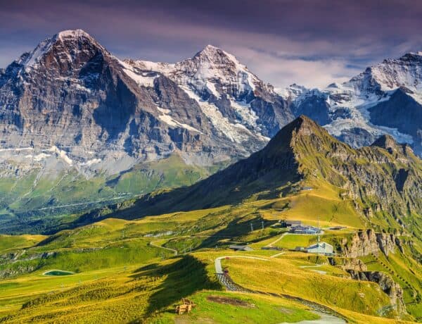
Top Alpine destinations for a family holiday in spring
Best places for a watersports holiday in the Alps
Top 10 ways to enjoy the mountains in spring, the elements to take into account to estimate the rental income from your chalet, subscribe to our newsletter.
Be the first to hear about beautiful new properties and exclusive offers

- As it happened: Breakaway win on stage 13 as Roglič reclaims time on O'Connor
Alpe d'Huez – The twists and turns of the 21-bend finale of the 2024 Tour de France Femmes
Taking a closer look at the iconic summit finish where the final battle for yellow will unfold

Even when you strip away all the fanfare and crowds of race day, the road up Alpe d’Huez still echoes with tales of some of the most memorable battles in cycling history, and on Sunday, August 18, 2024, the Tour de France Femmes will deliver another fresh chapter.
The 21 famous bends where so many thrilling battles of the men’s Tour de France have taken place are dotted with signposts counting down to the top. They provide more than a marker of the ever-increasing altitude, simultaneously paying homage to the winners of the stages that played out on the slopes of the 13.8km Alpine climb in the past. After the climb became the first summit finish of the Tour de France in 1952 the names that have earned themselves a place on those bend markers include Fausto Coppi, Bernard Hinault, Marco Pantani, Thibaut Pinot, Geraint Thomas and, most recently, Tom Pidcock . The question now is who will be the first rider from the Tour de France Femmes to be added to that list.
The inclusion of the Alpe d’Huez certainly adds another layer to the building of the mystique surrounding the latest incarnation of the women’s race, the Tour de France Femmes. It comes after the TdFF included the unrelenting Col du Tourmalet in 2023 – where Demi Vollering rode away to claim the dramatic queen stage and the yellow jersey – and the combined challenge of gravel and gradient on the La Super Planche des Belles Filles in 2022, won by the now retired Annemiek van Vleuten .
Still, it is not the first time the Alpe d'Huez has featured in the women's race for yellow. Over the decades, the climb that winds its way up from Bourg d’Oisans was included in different incarnations of the women’s event , from the official Women’s Tour de France, which ran through from 1984 to 1989 to the Tour Cycliste Féminin and the Grande Boucle Féminine Internationale, which last ran in 2009.
The details of those battles of old on the fabled mountain may not have drawn intense worldwide attention, though. But with the spotlight the Tour de France Femmes has turned on the sport, that will surely change in 2024.
The location

In the first edition of the Tour de France Femmes in 2022, the race ventured to the Vosges for its key climbing stages, then it was into the Pyrenees and up the Col du Tourmalet in 2023. The 2024 Tour de France Femmes route will take the race to the Alps for the first time, but the route to get there is somewhat unusual.
The 946km eight-stage and seven-day race from August 12-18 will work its way south from a Rotterdam start, first through Belgium before reaching France on stage 5 andthen heading toward back-to-back summit finishes for the final two stages.
Get The Leadout Newsletter
The latest race content, interviews, features, reviews and expert buying guides, direct to your inbox!
The first mountain day comes on stage 7, which is a 167km stage with 3,100m of climbing that ends on top of Le Grand-Bornand. Then the final finish line of the race comes on stage 8 atop Alpe d'Huez.
The Alpe d'Huez, when viewed in isolation, may not be one of the most formidable climbs in the race history. After all, it doesn't have the gravel sections or steep pitches of up to 20% of La Super Planche des Belles Filles and falls short of the 17km length of the Col du Tourmalet. However, there's always been so much more to the ascent than just 13.8km at an average gradient of 8.1%.
The history of the climb is heightened by the dramatic series of hairpins, raucous crowds and, importantly, the drama and ascents that have already unfolded earlier in the stage.
Before stage 8 finishes on the 21 hairpin bends, the 150km route with 3,900m of altitude gain will drop down from Le Grand-Bornand to traverse the Col de Tamié (9.5km at 4%) before the 30km mark has even been hit.
Then, there is a relatively flat stretch for more than 40 kilometres before the race reaches the Col du Glandon (19.7km at 7.2%) and the highest point of the day at 1,924m near the 100km mark of the stage. After rolling through Bourg d'Oisans, nestled in the valley, it is then onto the crowning climb, where the yellow jersey of the Tour de France Femmes will settle on the shoulders of the third winner of the race.
First, though, there are 21 hairpin bends to contend with. Though the cyclo-tourists may enjoy the numbered signs with the cute picture of marmots and homage to past winners, on race day they'll be lost in the crowds and all-encompassing effort the lead contenders will put into delivering the best finish possible in the world's biggest bike race.
It's no easy beginning, with the first two kilometres delivering gradients over 10% through the first five bends. There is a mild easing as the climb crosses the village of Le Garde with the gradient hovering from 9% to 7.5% through to the point where there is just over 5km remaining.
A brief reprieve at the village with a kilometre at 6.5% soon gives way to one of the toughest sections of the climb at 11.5%. The final three kilometres, in terms of gradient, are the easiest of the climb, with gradients of around 5%. But for many, they are likely to be the hardest of the 946km event, given the accumulated fatigue and how much will still be at stake in the race overall.

Everything is up for grabs on Alpe d'Huez as it marks the final climb on the final stage of the 2024 Tour de France Femmes. Gaps have already been built through the dramatic French stages but so much climbing is packed into the last 150km of racing on Sunday, August 18, there will be no chance for anyone to rest on their laurels until they cross the finish line on the open expanses of the summit of Alpe d'Huez.
Not only is the stage itself brutal, but with a week of racing already in the legs plus the Paris Olympic Games just before, there is no telling what havoc the accumulated fatigue could wreak. It will be a true test of stamina and climbing prowess. Kasia Niewiadoma (Canyon-SRAM), who was the runner-up on the Tourmalet in 2023, wears yellow ahead of stage 8, with a gap of 27 seconds to nearest rival Puck Pieterse (Fenix-Deceuninck), though it's the climbing specialists that are sitting over a minute back that are being focussed on as among the greatest threats to that overall lead. As the race leader herself said in the run into the brutally tough stage " the whole GC could be turned upside down ". 2023 Tour de France Femmes victor Demi Vollering, at 1:15 down, is of course prominent in the discussion, especially as she is supported by a powerful SD Worx-Protime squad. However, plenty of other riders will be lining up with dreams of claiming the prestige of a high overall finish or that first Tour de France Femmes Alpe d'Huez win. They range from Lidl-Trek's Gaia Realini and Shirin van Anrooij to Mavi García (Liv-AlUla-Jayco), Mareille Meijering (Movistar) and Sarah Gigante (AG Insurance-Soudal), while some other talented climber such as Neve Bradbury (Canyon-SRAM) and Niamh Fisher-Black) will instead be likely to be burying themselves to help their team leaders in the yellow chase. On the home front, the French climbers Juliette Labous (DSM-firmenich PostNL) and future teammate Évita Muzic (FDJ-SUEZ) are bound to have the loudest wave of cheers during their journey up the mountain. Muzic, in fact, has one of the strongest claims when it comes to the iconic finishing climb given her performance on La Laguna Negra at La Vuelta Femenina. She was the only rider who could stick to the wheel of an accelerating Vollering and then came around the Dutch rider on the last 50 metres to claim the stage win. Also in her favour is that she no doubt knows the climb like the back of her hand given its proximity to home. "I was dreaming for Alpe d'Huez on the Tour de France," said the FDJ Suez rider who finished eighth overall in 2022. "Now I live 40 minutes from Alpe d'Huez, so even more for me, it's really special to ride there." "And yeah, for sure, in my dream, I want to win on the top of Alpe d'Huez but we'll see also [about] the legs."
It's a climb where the "legs will really talk" but the volume will shoot to yet another level altogether for whoever wins, as it will be their name that is shouted across the history books.

Thank you for reading 5 articles in the past 30 days*
Join now for unlimited access
Enjoy your first month for just £1 / $1 / €1
*Read any 5 articles for free in each 30-day period, this automatically resets
After your trial you will be billed £4.99 $7.99 €5.99 per month, cancel anytime. Or sign up for one year for just £49 $79 €59
Try your first month for just £1 / $1 / €1
Simone is a degree-qualified journalist that has accumulated decades of wide-ranging experience while working across a variety of leading media organisations. She joined Cyclingnews as a Production Editor at the start of the 2021 season and has now moved into the role of Australia Editor. Previously she worked as a freelance writer, Australian Editor at Ella CyclingTips and as a correspondent for Reuters and Bloomberg . Cycling was initially purely a leisure pursuit for Simone, who started out as a business journalist, but in 2015 her career focus also shifted to the sport.
UCI MTB World Championships - Isabella Holmgren wins XCC U23 women rainbow stripes
UCI MTB World Championships - Albert Philipsen and Viktória Chladonová win junior XCO titles
UCI MTB World Championships - Riley Amos and Bjorn Riley go 1-2 for USA in XCC U23 men's race
Most Popular
Best French Alps Road Trip Itinerary: Annecy to Chamonix
Article written by Elisa This article may contain compensated links. Please read disclaimer for more info.
The French Alps is an incredible region of amazing landscapes, fairytale towns, and natural wonders perfect for nature lovers. The French Alps is a popular destination during the ski season, but anyone yet to visit the French Alps in summer is certainly missing out.
Are you planning a trip to the French Alps in the summer? This French Alps road trip from Annecy to Chamonix covers the French department of Haute-Savoie and allows you to experience the most iconic places in the region behind the wheels. This road trip through the French Alps is an ideal self-drive vacation for those who love sightseeing, nature, and good food.
This 7-day French Alps road trip itinerary is one of the best road trips in France . Read more about road tripping in France:

Road Trip French Alps – Overview
If you are looking for pretty mountain villages, gorgeous nature, and scenic drives in France, consider this French Alps road trip itinerary from Annecy that lasts 7 days.
- Start: Annecy
- Finish : Chamonix
- Duration: 7 days
- Suggested Route: Annecy – Yvoire – Avoriaz – Samoëns – Chamonix
- Total distance: 308 km, 6hrs 10min drive in total
- Regions covered: Auvergne-Rhône-Alpes
- Best for: landscapes, small towns, hiking, outdoor sports
Map of the French Alps Road Trip
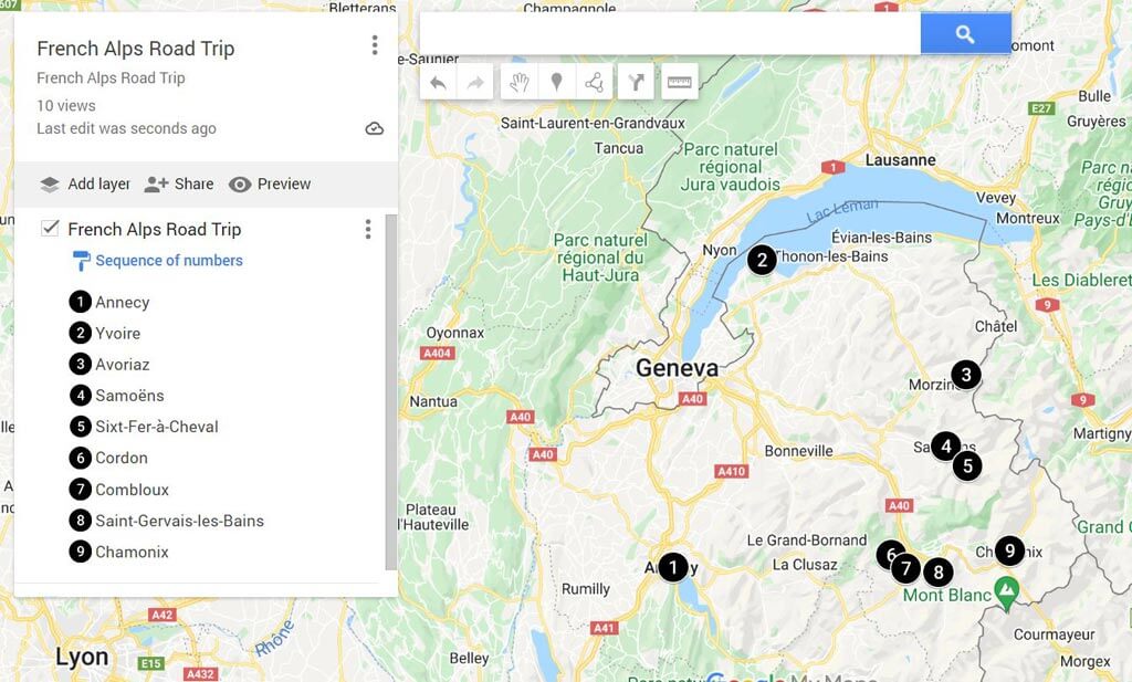
Click here to view this Map of the French Alps Road Trip on Google
7-Day French Alps Road Trip Itinerary
This road trip French Alps takes you over 308km through one of the most beautiful regions of France. Pass green meadows, deep blue lakes, mountain passes, and bustling villages.
For this French Alps road trip, you don’t need the car until you leave Annecy. If you need to hire a car, wait until then to pick up your rental car in Annecy.
We recommend booking your car with Discover Cars . This site is great because it takes all major rental companies, such as Hertz, Avis, and more, and compares prices for you. Check out our best tips for renting a car in France .
Click here to rent a car in Annecy
Day 0 | Arrival at Annecy
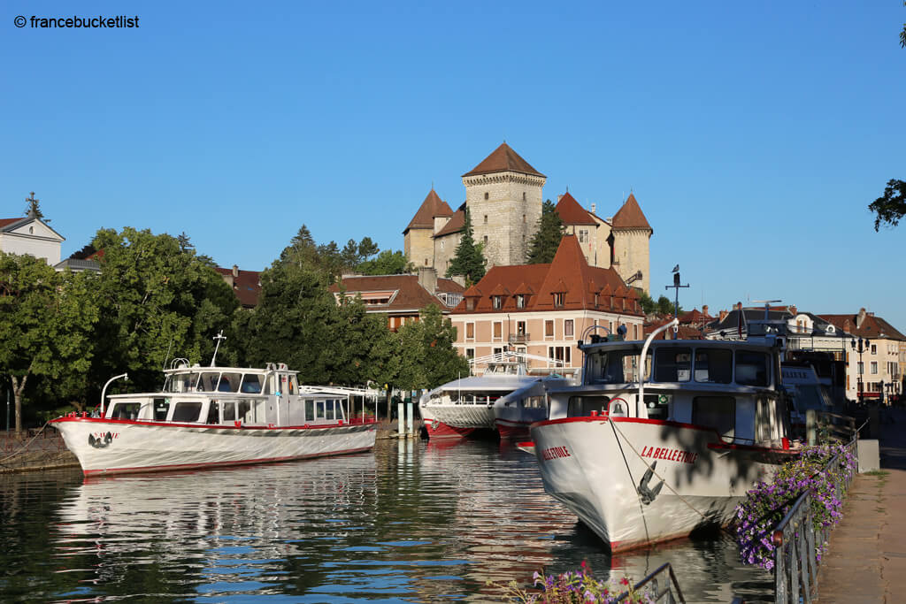
The starting point of this itinerary is Annecy , where we recommend spending two days exploring this Alpine city and its surroundings.
For your stay in Annecy, book a room at the beautiful Black Bass Hotel , a lovely property located by the lake just out of Annecy and with free public parking available on site. The hotel has comfortable and stylish rooms, a pool, and beautiful grounds with lake views.
Click here to book your stay at Black Bass Hotel
Day 1 | Annecy
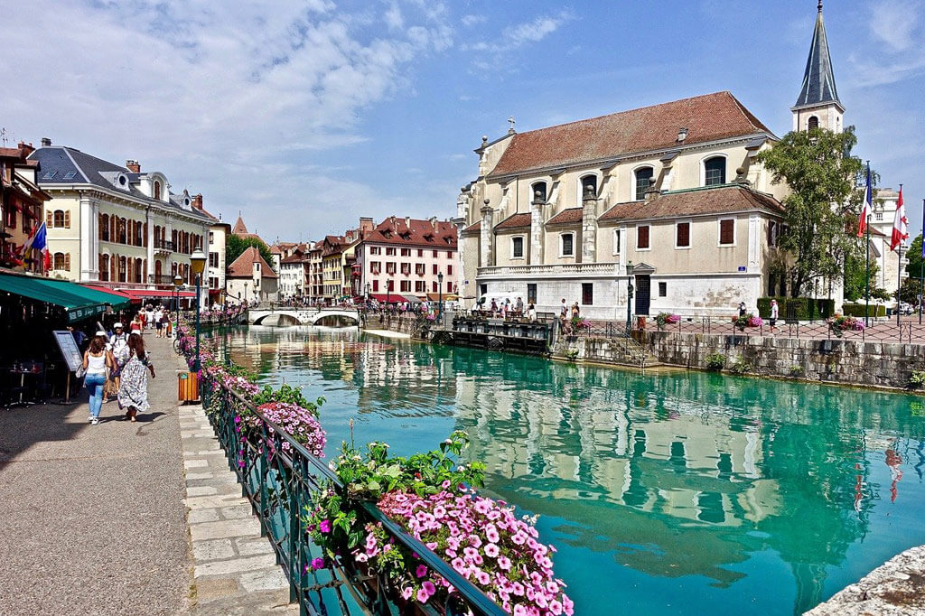
Fairytale Annecy is one of the most beautiful cities in France and a must on any trip to the French Alps in the summer. Located by the lake of the same name, Annecy has many historical and natural highlights. Annecy is also an excellent place to enjoy great regional food and wines.
Above all, Annecy is known for its Old Town , which is particularly beautiful to discover. The first day of this itinerary necessarily involves a walk around its medieval city center, with narrow winding streets and colorful architecture. During your walk, don’t miss the Palais de l’Isle (the symbol of Annecy), the 16th- century Cathédrale de Saint-Pierre , and the imposing Château d’Annecy .
Often nicknamed the Little Venice of the Alps , the canals of Annecy offer great viewpoints of the city. Take the time to look for the prettiest canals, always full of flowers, for some perfect postcard pictures.
For more ideas for your stay in Annecy and places to eat, check out this Annecy itinerary .
Day 2 | Lake Annecy
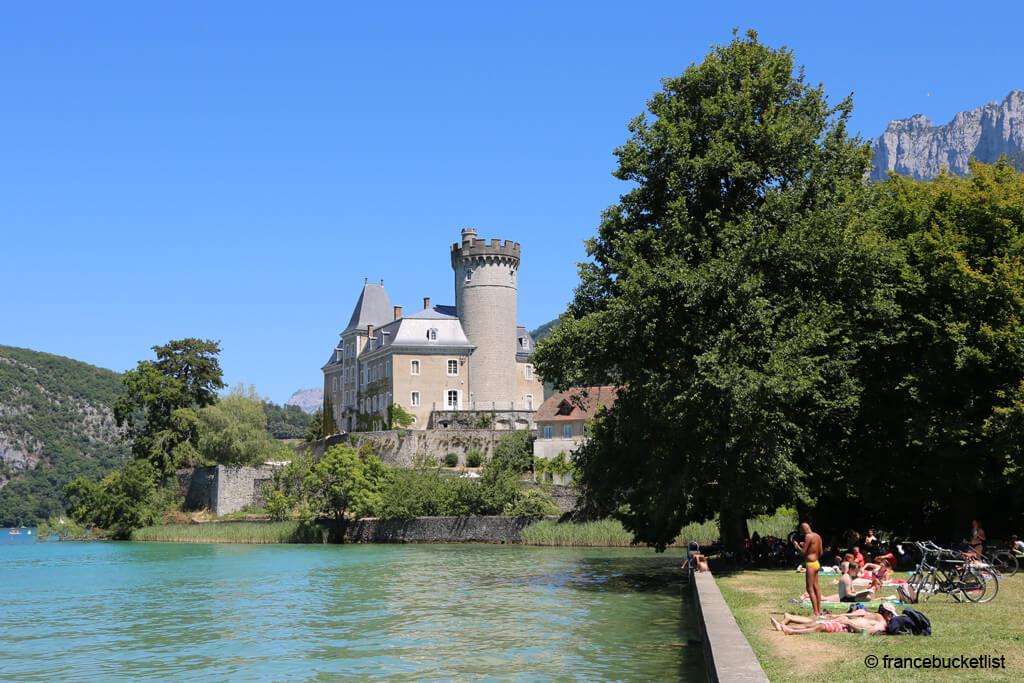
The second day in Annecy is used to exploring the lake’s surroundings. If you love biking, there are 42 km of cycle paths for your delight. You can decide to do the lake’s full tour to explore the lake’s small towns or spend a lazy day at one of the beaches.
We did a combination of both and found in Plage du Château the perfect spot for a picnic on the grass and a bath with a view. The castle in the background is Château de Duingt , built on a small peninsula.
Day 3 | Yvoire

Day 3 of this French Alps road trip takes you north to the lovely Yvoire . This picturesque village located on the French shore of the Lac Léman (Lac Genève for the Swiss) is listed as one of the Most Beautiful Villages in France .
For your stay in Yvoire, book one night at Villa Cécile . This property is located a mere 6-min walk to the lake, offers chick and cozy rooms, and has a swimming pool and a spa. The on-site restaurant overlooks the lake and serves traditional cuisine and local wines.
Click here to book your stay at Villa Cécile
Yvoire is one of the prettiest medieval towns in France , with over 700 years of history, and we are sure you will enjoy visiting its ramparts, medieval castle, fortified gates, and cobbled streets.
Don’t miss the Jardin des Cinq Sens , in the heart of the village, listed as a remarkable garden by the Ministry of Culture. The Old Town also has many pretty shops to buy souvenirs and regional products. In the afternoon, enjoy a drink or dinner on one of the terraces by the lake.
Not far from there, Plage d’Excenevex is a natural sand beach with shallow waters that welcomes beach huts and beach volleyball all summer long. Here, you will have your feet in the warm sand and your eyes on the Alpine peaks… the place is unique!
Day 4 | Avoriaz
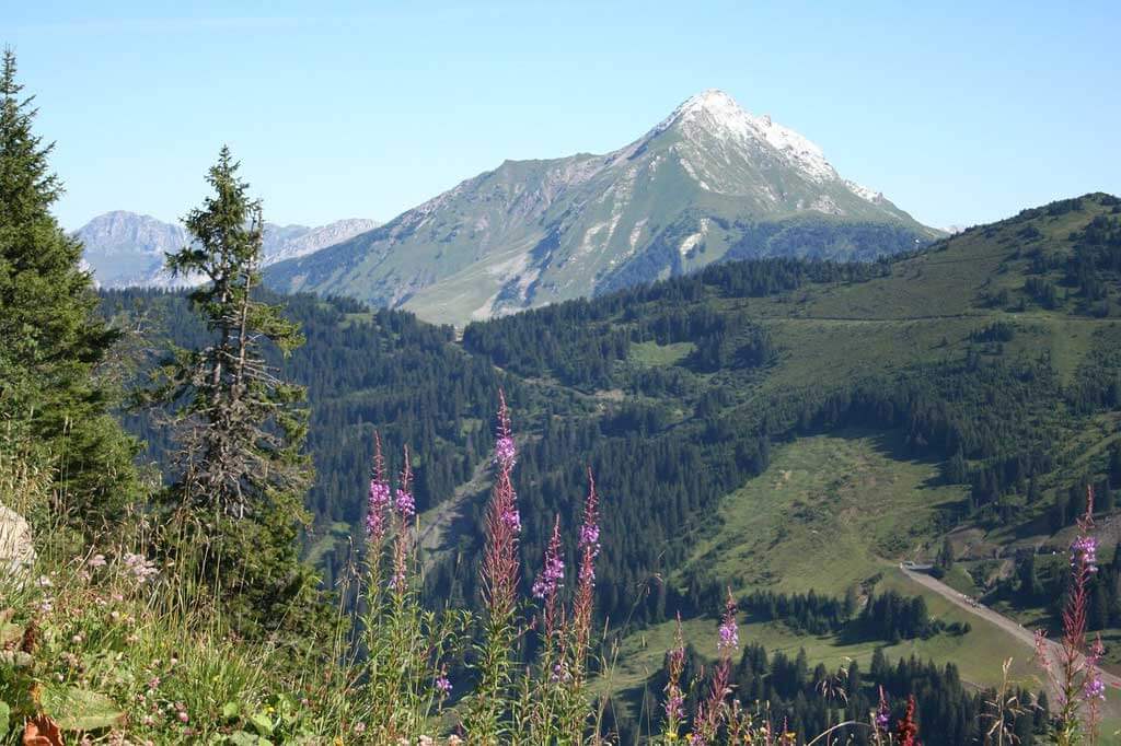
From Yvoire, take road D1005 then road D902 to Avoriaz. This is a 61 Km drive that takes around 1hr 10 minutes.
Avoriaz is one of the best ski resorts in the French Alps , born from the audacity and dream of a local man from Morzine, the town below. Read the story below:
Jean Vuarnet was an outstanding skier and Olympic champion from Morzine. After skiing all over the world, Morzine wanted to keep him in the village to develop a new ski resort.
Jean Vuarnet then set himself the challenge of creating an ideal ski resort from scratch, high up in the mountains, where the snow is exceptional, and the panoramas are grandiose.
He had to convince bankers to help him carry out this risky bet, as this was a hostile and inaccessible area in winter. The team attracted ambitious and avant-garde young architects, Jacques Labro in the lead, to build a station with innovative and contemporary architecture, a ‘snow metropolis’ far from the traditional Savoyard style, but integrated into the landscape and the context of the mountain.
The first modest ski station opened its doors in 1967 with a hotel (the Hôtel des Dromonts ) and a few slopes. Over the years, the station grew from bottom to top with new areas and facilities with a unique result.
Its originality has never ceased to be debated. Avoriaz, you love it or you hate it, but you can’t remain indifferent! Avoriaz still remains modern and avant-garde. In 2003, it even received the label Great Achievement of the Twentieth century .
Day 4 explores Avoriaz and its surroundings. There’s no snow in Avoriaz in the summer, but plenty of fun activities to keep you busy for a while: hiking, canyoning, rafting, paragliding, kayaking, golf, and yoga.
For your stay in Avoriaz, we can only recommend the iconic Hotel des Dromonts , the heart of that former ski station. Since its construction, the hotel has been renovated but still keeps its sixties atmosphere, excellent service, and all the comforts of today for a cozy stay. Book two nights.
Click here to book your stay in Hotel des Dromonts
Day 5 | Samoëns – Cirque Fer à Cheval
Day 5 of this French Alps road trip itinerary visits Samoëns – Cirque Fer à Cheval on a day trip from Avoriaz.
Day Hike at Cirque du Fer-à-Cheval
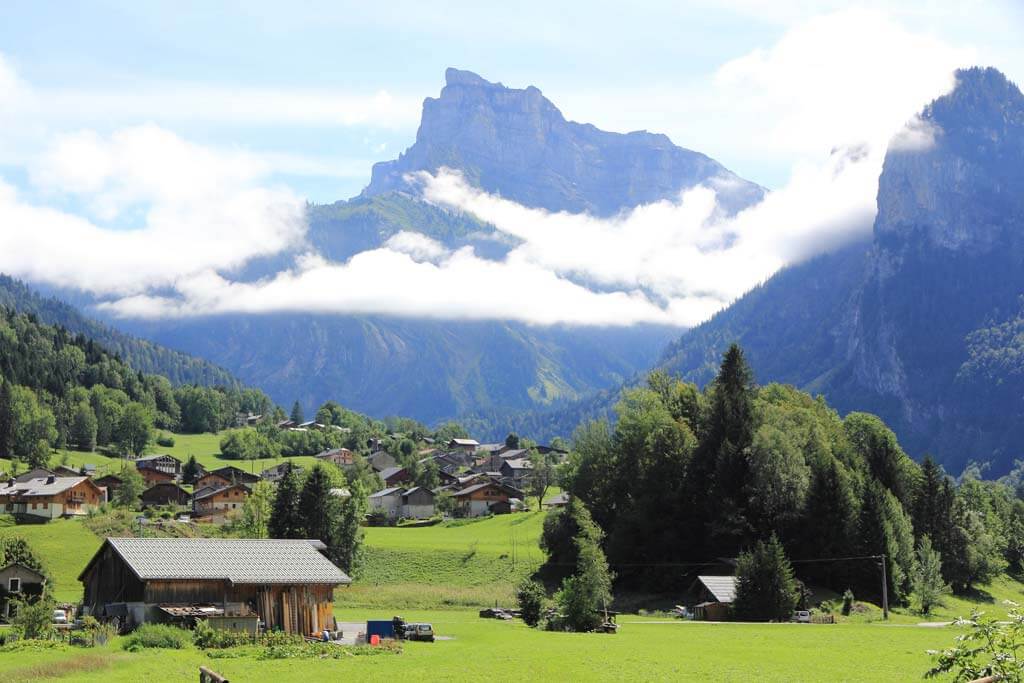
The Cirque du Fer-à-Cheval is the largest mountain cirque in the Alps. Lying at the eastern end of the Giffre Valley, the Cirque du Fer-à-Cheval forms an immense amphitheater almost 5 km across and bounded by 500- to 700-m high limestone cliffs. The Cirque is breathtakingly beautiful throughout the year, but it is most spectacular in the spring when melting snow swells its waterfalls to majestic proportions. There are more than 30 waterfalls in Cirque du Fer-à-Cheval!
The Cirque du Fer-à-Cheval is part of a nature reserve, and it is not uncommon to discover, clinging to the vertiginous cliffs, several ibexes and marmots.
To explore this wonderful area, we recommend this easy hike (9,3km round trip, 3 hrs 30 min) which starts from Fer-à-Cheval’s car park (GPS Coordinates (WGS 84) of the Starting Point: 46.077278, 6.836917 ). Pic de Tenneverge (2989 m) and Tour du Prazon (2929 m) dominate the landscape during the greater part of the itinerary.
Or Visit Samoëns

If you prefer a more tranquil day, visit Samoëns , a lovely mountain village renowned for its traditional stone masonry-based architecture. The village resort offers a wide range of activities on land, water, or in the air, all in an absolutely superb setting.
Don’t miss the former indoor market and the Gros Tilleul (ancient linden tree) which still bear witness to an ancient past. Notre Dame de l’Assomption Church is a wonder and the best example of the village’s renowned stone cutters.
Not too far away, the Jaÿsinia Alpine Botanical Garden is an invitation to relax and unwind while exploring a natural treasure right at the heart of the village.
Day 6 | Avoriaz to Chamonix
Day 6 of this road trip French Alps takes you to Chamonix, one of the French Alps’ prettiest towns and the most popular. To get there, you will take your time: the journey is as beautiful as the final destination.
From Avoriaz, take the road D902, then the D1205 direction to Chamonix. On the way, there are three lovely villages great for a break to stretch your legs and some sightseeing.
Morning in Combloux or Cordon
Don’t miss these two farming villages, well-known for their incredible views over the iconic Mont Blanc and superb baroque architecture.
Nicknamed ‘the Pearl of the Alps, ’ Combloux enjoys an enviable position facing Mont Blanc, which takes shape between the Aiguille de Bionassay and the Aiguille du Midi.
As soon as the mountain pastures turn green, Combloux is the starting point for many beautiful hikes. The warmer seasons are also a good opportunity to enjoy local festivals and discover the Combloran heritage, the Slope Museum, and the Granite trail. In the summer, a dip in the Plan d’Eau Biotope is a must. This ecological pool, where water is filtered by 10,000 aquatic plants, is one of the most beautiful in France with the eternal snow in the background.
Cordon is another charming village on the way to Chamonix. With a superb location facing the iconic summit, Cordon is nicknamed ‘the Balcony of Montblanc’ . Cordon is a place to relax and admire its beautiful architecture and unspoiled nature.
With its 89 bread ovens, bread and quality local food, in general, is a serious matter. Do not miss the walk to the Abérieux Farm to taste their traditional cow cheese.
Afternoon Saint Gervais-les-Bains
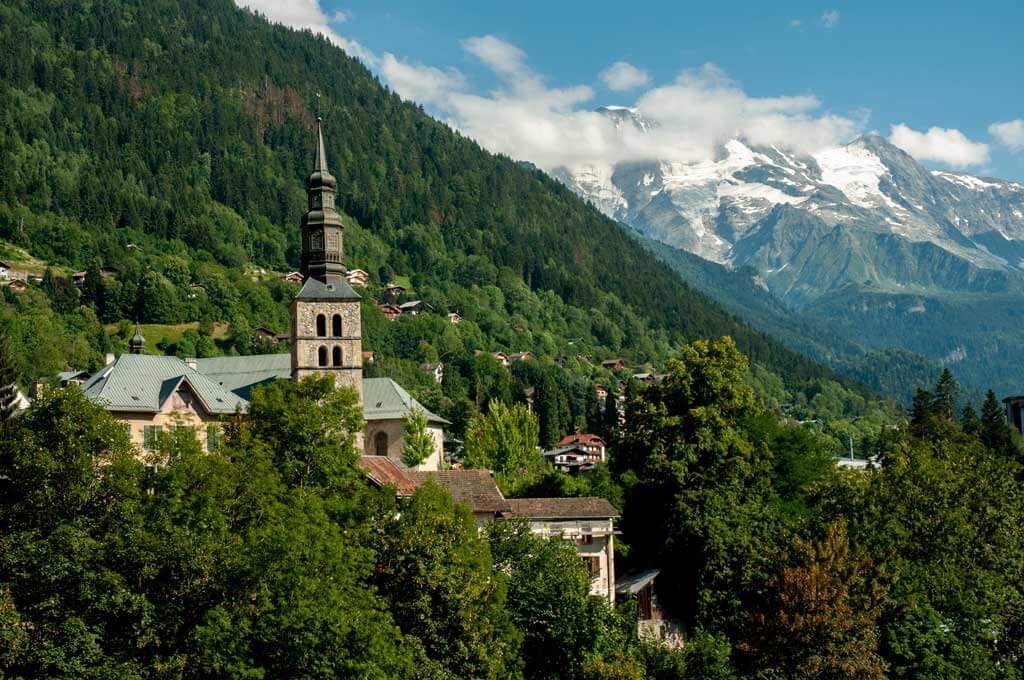
Saint Gervais is a great stop for today’s lunch break and more sightseeing. Located at 850 meters, and surrounded by 4,000-meter peaks, including Mont Blanc (4,810 meters), Saint Gervais-les-Bains has a definite alpine feel. Its name comes from the town’s 39C natural spring waters, converted today into a world-class spa.
St Gervais boasts three major tourist attractions: the Tramway du Mont Blanc , taking visitors up to the Glacier de Bionnassay (2,372m); the Bettex/Mont d’Arbois cablecar , which offers stunning views over Mont Blanc and several good walking options; and the above mentioned Thermes du Mont Blanc .
In addition, St Gervais has a number of good restaurants (including a 1-Michelin starred restaurant), cozy cafes, trendy bars, and quality food shops, being a great place to relax, soak up the mountain air and enjoy the best French produce.
Today, the journey ends at Chamonix, which really needs no introduction. For your stay in Chamonix, book two nights at Auberge du Manoir . This lovely property with a convenient location has comfortable rooms, a bar, private parking, a garden, and a terrace. If possible, book a room with a balcony-mountain view.
Click here to book your stay at Auberge du Manoir
Day 7 | Chamonix
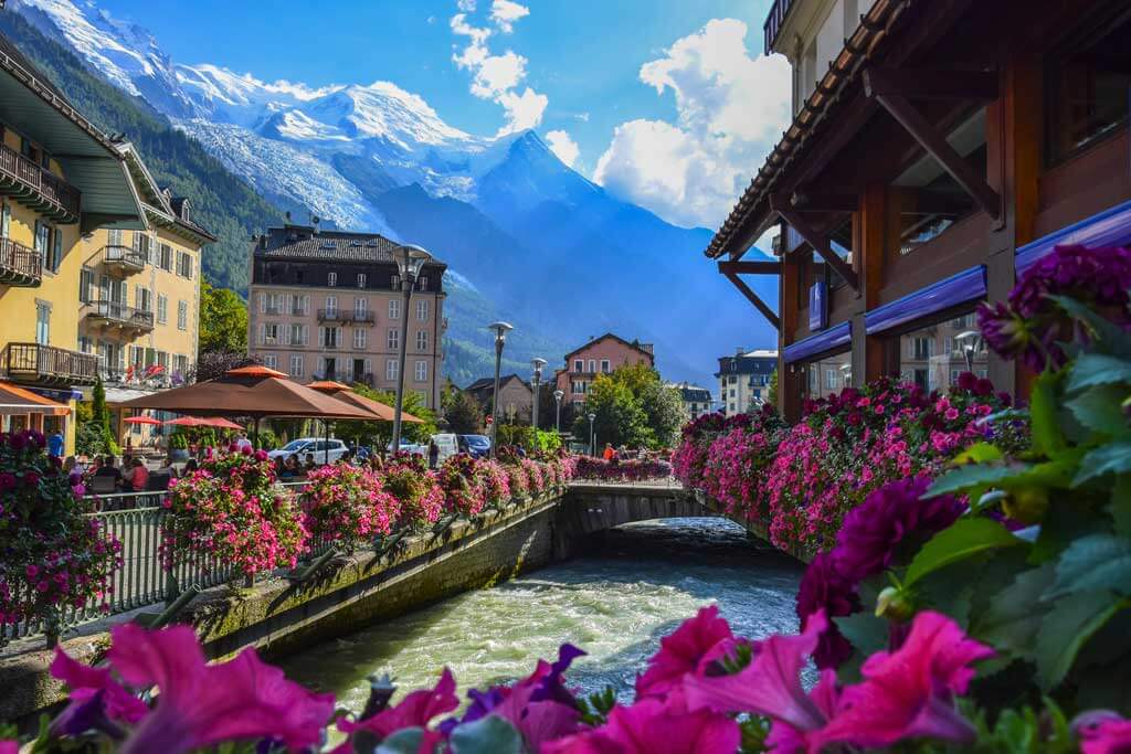
The last stop of this French Alps road trip is Chamonix. Chamonix is a world-known ski resort that first became famous in 1924 for hosting the Winter Olympics. Nestled in the Arve Valley at the foot of Mont-Blanc, Chamonix comprises 16 charming villages and hamlets, including Argentière, Le Tour, and Montroc.
Here, the natural scenery, so picturesque under the snow, is equally beautiful in the summer and best explored by following one of the surrounding trails.
Chamonix’s main tourist attraction is l’Aiguille du Midi , which is easy to visit by cable car (30 min) from the center of the town. You can also take Chamonix’s Montenvers railway train through forests, tunnels, and viaducts to the famous Mer de Glace glacier (1,913m), the largest glacier in France.
Other fun activities in Chamonix are the Ice Cave , the summer luge (Chamonix roller coaster in the mountains!), or a stroll along the town’s pretty alleys lined up with shops and galleries.
If you have more days available, you can extend your stay in Chamonix or drive to Grenoble and then down to the coast following the Napoléon Route .
So what are you waiting for? Book this road trip from Annecy to Chamonix in the French Alps today!
Back to Homepage
Disclaimer: This article may contain compensated links, meaning we get a small commission if you make a purchase through our links. It costs you nothing more (in fact, if anything, you’ll get a nice discount) but helps us to go on creating incredible French content for you. We trust all products and brands promoted here and would never recommend anything that isn’t of value. Please read disclaimer for more info.
(C) Copyright 2019 - 2024 France Bucket List. All Rights Reserved. Designed & Developed by France Bucket List || Disclaimer || Privacy Policy || Contact |
NEW! Find where to watch all of your favorite sports!
Tour de France route goes twice through Alps, no Paris finish
- ESPN News Services

Next year's Tour de France will feature two treks through the Alps as organizers avoid Paris as it hosts the Summer Olympics, while the women's race will have a grand finale at L'Alpe d'Huez in August.
For the first time since its creation in 1903, the men's Tour will not finish in Paris, with the winner being crowned in Nice on July 21 after the race's first Grand Depart in Florence, Italy, on June 29 in a stage that includes more than 11,000 feet of climbing.
With the Olympics being staged in Paris from July 26 to Aug. 11, organizers decided, following talks with the government, to ease the pressure on the police force by avoiding the capital.
"We were committed to avoid Paris because of the Olympics," Tour director Christian Prudhomme told Reuters. "There are only 28,000 police forces available, and we knew we could not get more."
🤩 Here it is, the official route of the #TDF2024 ! 🤩 Voici le parcours officiel du #TDF2024 ! pic.twitter.com/3ORf31AS4T — Tour de France™ (@LeTour) October 25, 2023
There will be four stages in Italy, with some great names being honored as the second stage will start near the late Marco Pantani's birth town and finish in Rimini, where he died in 2004.
The peloton will enter the Alps as early as the fourth stage and will return for the final block of racing, which will be decided with a mountain stage ending at the Col de la Couillole and a hilly individual time trial between Monaco and Nice.
It will be the first time since 1989 that the final stage of the race will be actually competed. Since Greg LeMond won a time trial on the Champs-Elysees to pip France's Laurent Fignon by eight seconds in the overall rankings, the final stage has always been a procession, with only the final sprint being contested.
"The last three four days will be very tough because we will be in the mountains," Prudhomme told Reuters.
There are a total of seven mountain stages on the program, across four mountain ranges, as the total vertical gain of the 111th edition of the Tour reaches 52,230 meters (over 170,000 feet).
Defending champion Jonas Vingegaard and runner-up Tadej Pogacar, if he takes part, will once again be the favorites.
There are eight flat stages for the sprinters, leaving plenty of opportunities for Mark Cavendish to try to become the outright record-holder for most career stage wins at the sport's biggest race.
🤩The official route of the #TDFF2024 avec @GoZwift ! 🤩 Voici le parcours officiel du #TDFF2024 avec Zwift ! #WatchTheFemmes pic.twitter.com/rl14MqCXdn — Le Tour de France Femmes avec Zwift (@LeTourFemmes) October 25, 2023
The women's Tour begins Aug. 12 and will also avoid France for the first three days, racing in the Netherlands and Belgium, with the finale set for L'Alpe d'Huez.
"We went to the Tourmalet last year, we wanted to go to iconic places, and L'Alpe d'Huez is part of cycling's history," women's Tour director Marion Rousse told reporters. "It's the toughest stage in Tour de France Femmes history with 4,000 meters of altitude gain. The stage also features the Col du Glandon, which I think is the hardest in France. Women have proved they have the level for that."
The race will feature eight stages and a total of 946 kilometers (587.8 miles).
The Associated Press contributed to this report.
Slovenia's Tadej Pogacar wins Tour de France for the 3rd time
Pogacar, 25, is the first cyclist to win the giro d’italia and tour de france in the same year since 1998., published july 21, 2024 • updated on july 21, 2024 at 4:03 pm.
Tadej Pogacar won the Tour de France for the third time and celebrated in style with a victory in Sunday's final stage — a time trial ending in Nice.
The 25-year-old Slovenian rider became the first cyclist to secure the Giro d’Italia and Tour de France in the same year since the late Marco Pantani in 1998.
📺 24/7 South Florida news stream: Watch NBC6 free wherever you are
Two-time defending champion Jonas Vingegaard of Denmark was second overall. He also finished the 21st and final stage in second place.
Pogacar won the 34-kilometer (21-mile) time trial on the French Riviera's roads from Monaco to Nice in 45 minutes, 24 seconds. Vingegaard was 1 minute, 3 seconds behind him and Belgian rider Remco Evenepoel 1:14 back in third spot.
The Hurricane season is on. Our meteorologists are ready. Sign up for the NBC 6 Weather newsletter to get the latest forecast in your inbox.
2024 Paris Olympics: See dates, sports, how to watch and more
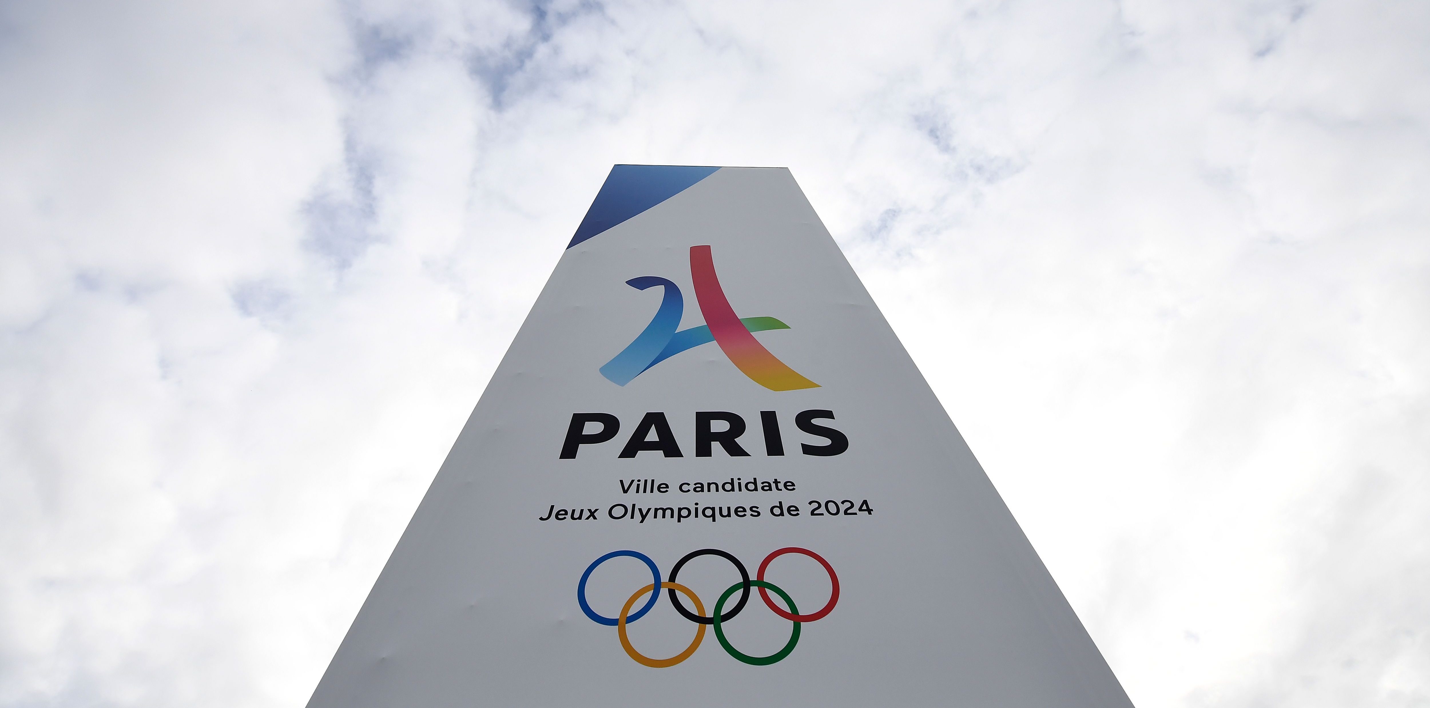
Here are the rules for the 2024 Olympics in Paris

Get to know Team USA Olympians ahead of the 2024 Paris Olympics
In the overall standings, Vingegaard finished 6:17 behind Pogacar and Evenepoel was third overall, 9:18 behind Pogacar — whose other Tour wins came in 2020 and 2021.
The race did not finish in Paris as it usually does because of the Olympic Games. Nice mayor Christian Estrosi called the region between the Mediterranean Sea and the southern French Alps “perfect cycling territory.”
From early Sunday morning, fans camped along the popular Promenade des Anglais in Nice to guard a spot that would offer the best glimpse of cyclists.
Some fans chanted “Remco, Remco” as the race-against-the-clock specialist zoomed past them.
They may have been surprised to see Pogacar going flat out.
After his explosive attack on Friday, Pogacar said he would not try to win Saturday’s stage. But the UAE Team Emirates rider could not resist and won that to become the second man to win five mountain stages in one Tour after Italian rider Gino Bartali in 1948.
Pogacar had no need to attack on Sunday, either, considering he led Vingegaard overnight by more than five minutes.
But the lure of another stage win proved too strong and he flew down the winding roads past picturesque Èze and Villefranche-sur-Mer on the approach to Nice, where the route flattened out again.
Pogacar held out three fingers as the finish line and a sixth stage win approached on this year’s Tour — the same number of stages he won when dominating the Giro d’Italia.
It was Pogacar’s biggest winning margin of his three Tour wins — beating the 5:20 gap on Vingegaard three years ago, but below the 7:29 victory margin Vingegaard enjoyed over Pogacar last year.
The battle with Vingegaard was not as close as it might have been in different circumstances.
The 27-year-old Vingegaard was hospitalized for nearly two weeks in April following a high-speed crash in the Tour of the Basque Country. He resumed competitive racing only on this Tour.
Ecuadorian Richard Carapaz won the best climber's polka dot jersey while Eritrea's Biniam Girmay won the top sprinter's green jersey and the 24-year-old Evenepoel capped a fine debut Tour with the white jersey for best young rider.
Associated Press writer Barbara Surk in Nice contributed to this report.
This article tagged under:
How to Use Rouvy for the Ultimate Indoor Riding Experience
Learn how to ride against the pros, see how you measure up on Strava, and ride for free.

Gear-obsessed editors choose every product we review. We may earn commission if you buy from a link. How we test gear.
Rouvy’s Origin Story
What it’s like to ride with rouvy, how rouvy compares to zwift and fulgaz, how to start using rouvy.
Have you ever wondered how the Tour de France Femmes avec Zwift racers like Demi Vollering and Katarzyna Niewiadoma felt climbing Alpe d‘Huez ? Maybe you’re intrigued to see how you’d fare against Jonas Vingegaard or Tadej Pogačar on stage 9 of this year’s Tour de France? But you probably don’t have time, finance, or any serious plans to ride in these places anytime soon.
Worry not, as Rouvy, an indoor training platform used by Lidl-Trek men’s and women’s teams, can take you there without leaving home.
Much like Zwift , Rouvy allows cyclists to race and train indoors but unlike Zwift, you ride in real-world scenery, which is how the pros used it to practice riding the 2024 Tour de France and Tour de France Femmes courses before heading to the start.
With an extensive rolodex of cycling routes, all converted from video recordings, you too can ride in cycling hotspots like Switzerland, California, Italy, and New Zealand. These routes can bring your wanderlust adventures to life or visually enhance your next VO2 max training session . Regardless of your preference, you can always find a route that’ll motivate you to keep going.
Here’s everything you need to know about how to use Rouvy and why you should add it to your training repertoire.
In 2017, Czechian brothers Petr and Jiri Samek set out to make indoor cycling less boring. Instead of setting up a trainer and adding entertainment, the brothers wanted to make the ride the entertainment—just like real life. To bring indoor rides to life, Rouvy’s creators filmed, digitized, and connected GPS coordinates to each route so users could ride them indoors with a smart trainer .
Around 2018, Rouvy bumped things up a notch by adding augmented reality (AR) to some of the traditional 2D recorded routes. These AR routes, of which there are about 19,000 miles to ride, feature animated 3D riders, race markers, and pace partners overlaid on 2D videos.
On the app, you can either ride solo by choosing a non-AR route or if you’d like some company, you can find an AR option to suit your ride preferences and mood. Either way, you’ll experience climbs , descents, and turns that mimic the outdoors.
In addition to changing how you experience routes on an indoor trainer, Rouvy has broadened their catalog in recent years. You can easily find segments from current Grand Tour races including the Tour Down Under , La Vuelta, Strade Bianche , Paris-Roubaix, and even past Olympic and national championship routes.
With an aim to give “more scenery” and “less graphics,” Rouvy offers real-world routes to make the experience look more realistic. On these routes you can ride for fun, train, and even race .
When using the noncompetitive “just ride” mode, you can ride at your own pace and manually adjust the resistance level to give your ride a more realistic feel. You can reduce the resistance to as low as 30 percent to make riding up a climb more manageable or as high as 150 percent to simulate an attack or practice pushing harder.
If you’ve got some energy to burn, you can also opt for the “time trial” mode in which you ride against the clock, either solo or as part of a group. Like a real time-trial event, you can’t pause or take a coffee break, and your time only counts if you complete the event.
If you’d like to see how your time trial effort stacks up to riders in the real world, you can link your Rouvy and Strava accounts. When linked, you’ll get a notification on Rouvy once you approach a real Strava segment. When the segment starts, Rouvy will display the avatar of the King and Queen of the Mountain and even your PR avatar (if you’ve previously ridden that segment). As the segment progresses, your effort will determine how your avatar stacks up against the KOM, QOM, and your own PR.
At the end of the segment, Rouvy saves your effort and you have a chance to get on Strava's leaderboard along with riders competing on the same Strava Live Segment in the real world.
Both FulGaz and Rouvy provide real-world immersive video experiences in high quality resolution. You can stream Rouvy in standard definition, high definition, full high definition, or 2K (even better than high def), whereas FulGaz has 4K resolution. In some ways FulGaz videos are like Rouvy’s non-AR videos because they don’t have virtual banners, ghost riders, or pace partners.
Both Zwift and Rouvy feature the highly popular Alpe d’Huez climb, called Alpe Du Zwift on Zwift. The 21 switchback-route is the same on both platforms, however, the immersive feel on the historic climb differs significantly with Zwift’s digitized world.
Both Zwift and Rouvy also feature segments that give you the opportunity to push your watts, however Zwift segments don’t align with real-world Strava Live Segments.
All three apps allow you to ride, race, complete structured workouts , and adjust the course resistance.
As for pricing, Rouvy offers a seven-day free trial period. You can then choose from six subscription options including a monthly plan that costs about $12 and yearly plan that costs about $149. Plans are available for single, duo, and groups of up to five members. Annual memberships can be paused for up to 180 days, but if you’d like to ride or race during the paused period you can purchase a 24-, 48-, or 72-hour daily pass for $3, $4, or $5.
FulGaz offers a 14-day trial period after which you can purchase a monthly membership for $15 or an annual membership for $126. You can pause monthly memberships but not annual memberships.
Zwift offers a monthly subscription for $20 and an annual subscription for $200. There is a 14-day free trail period for new monthly memberships but the annual plan does not offer a trial period. (However, if you’re new to the platform you cancel within 30 days for a refund.)
All three apps are compatible with a variety of power meters, smart bikes, and smart trainers from popular brands including Elite, Jet Black, Saris, Wahoo, and Zwift. You can also ride Rouvy with a grade simulator from Wahoo or Elite. Zwift is compatible with wheel-on trainers and rollers but you’ll need a power meter if the device doesn’t have a built in sensor to transmit power data.
To experience Rouvy, create a user account online and download the app to your computer or mobile device. Sign into the app using the same username and password from the website.
Once logged in, the app will allow you to connect to most smart trainers and bikes, grade simulators, power meters, heart rate monitors, and cadence sensors via Bluetooth, ANT+, or manually. If you have a classic or turbo trainer, Rouvy notes you’ll need a power meter , speed sensor, or cadence sensor.
Before clipping in , you can customize your avatar’s body (male or female), cycling kit, bike (frame and wheels), and clothes (glasses, shoes, and socks). As you gain experience on the app, you can upgrade bike frames, jerseys, bibs, helmets, gloves, and more. (FYI, you can do this on Zwift too, but not on FulGaz as the avatar feature has been removed from the app until further notice).
If you cancel your account for any reason Rouvy still wants to keep you riding, so the app allows you to ride up to 20K, or about 12 miles, every month for free—no strings attached. This is a good deal for those days when the weather, your job, family, or life gets in the way.
How many routes does Rouvy have?
Rouvy offers more than 25,000 routes of varying lengths from across the globe. These routes include legendary climbs and descents to cobblestone and gravel routes. Of these routes, nearly 1,000 are Strava Live Segments, and more than 1,300 are AR routes in nearly 50 countries.
Do you need a strong internet connection for Rouvy to work?
Yes. Because Rouvy videos are recorded in 2K resolution, high-speed internet service is required to ensure stable video quality. Slower internet speeds can result in extensive buffering and video interruptions.
However, Rouvy allows you to download routes to your devices to prevent video-quality download interruptions to immediate and future rides. You can ride downloaded routes offline at anytime and your ride results will be uploaded when your device reconnects to the internet.
How can you find different routes and workouts on Rouvy?
Using the search feature in the app, you can type in a portion or the full name of an event or segment. Also, you can filter routes by time, terrain, type of course, event, and more. If you’re only interested in riding a Strava segment, non-AR route, or only on certain continents, Rouvy can also filter that for you.
In terms of workouts , you’ll find them sorted by recommended routes, trending routes, route collections, and the latest official routes. The app may recommend up to 10 routes ranging from 45 minutes to more than six hours. Many of these courses are segments of a larger events like La Vuelta . You can also opt for a structured workout to increase your FTP , climbing ability, or VO2 max.
Route collections are exactly that: a number of routes that align with a particular type of ride, such as scenic rides, gravel , downhill, or even rides that traverse Mallorca, Spain. The latest official routes feature segments from recent events. For example, the app currently highlights 27 new routes of La Vuelta 2024, which runs from August 17 to September 8.
How can you earn coins on Rouvy?
With a range of distances and elevation challenges to suit every rider, Rouvy annotates the number of workouts required to complete a specific challenge like La Vuelta Virtual Medio , which has seven workouts while La Vuelta Virtual El Diablo has 21 workouts.
Each workout specifies how long the challenge lasts, how many people are registered, and how many coins you will have when you’re all done. You can use coins to upgrade your avatar’s accessories like helmet, socks, and jersey. You can also earn experience points which count toward your Rouvy career and eventually, you can earn “legend” status.
How can you ride with others on Rouvy?
A Rouvy rider never needs to ride alone. Every route features an icon indicating the number of riders along it. If the riders on the route have already started, use the “set your ride” page to add virtual partners and up to 10 ghost riders to keep you motivated and encouraged along the way.
You can also join races or group rides. With events featured around the clock, just jump in when you can. Before joining a race or ride, check out the route information, then take a peek at the participant list. Each event not only specifies the number of riders registered for the event, but the start list annotates each rider’s age, functional threshold power (FTP), and country. This will show you whether you’ll be riding within your FTP range or working to keep up.
Also, if you start or join a group ride or workout, the app has a “rubber band” feature to keep the group together. If someone in the group falls behind the leader, the app gives them a boost.
What are the best routes on Rouvy?
Rouvy’s 10 most trending routes for 2024 right now include Lago di Garda in Italy; Colorado River in Utah; Obergesteln-Fiesch in the Swiss Alps; Avenue of the Giants in California; Cheddar Gorge in Britain; Alpe d’Huez in France; Lake Pukaki in New Zealand; Nusfjord to Haukland Beach in Norway; Paris; and Las Vegas.
Can you race with professional cyclists on Rouvy?
Yes, kind of. If you really want to see how you stack up against the likes of Wout van Aert and Tadej Pogačar, you can try to time when they’ll reach a particular segment of a course and race them in real-time while riding in the app and watching the broadcast on your TV.
For past events, like the Tour de France, you can still try to race the pros. Make sure your Rouvy and Strava accounts are linked, give your best effort when the Strava Live Segment notification pops up, and validate your efforts on the Strava leaderboard to see how you compare to the pros.
Taneika is a Jamaica native, a runner and a gravel cyclist who resides in Virginia. Passionate about cycling, she aims to get more people, of all abilities, to ride the less beaten path.

Indoor Cycling

The Benefits of Riding an Indoor Trainer All Year

The 10 Best Indoor Cycling Trainers

Indoor Rides Inspired By the TdF

The 9 Best Stationary Bikes

Indoor vs Outdoor Cycling: How They Compare

Get Ready for the Zwift Games Like a (Former) Pro

Wahoo Kickr Core Zwift One Indoor Trainer Review

170-180 BPM Playlist for Indoor Cycling

The Best Zwift Workouts

Peloton vs Zwift: Which One Should You Choose?

The Best Virtual Cycling Challenges

30-Minute Spin Workouts to Boost Your Fitness
COMMENTS
The Route des Grandes Alpes, also known as the Great Alpine Road, was proposed in 1909 by the Touring Club of France as a way to connect the northern and southern Alpine valleys and promote tourism in the area. ... Because this place has been crossed many times by the Tour de France. But also, because the landscape around this pass is extremely ...
4. Apennines (Italy), the Italian and French Alps, Massif Central and Pyrenees will be the mountain ranges on the 2024 Tour route.. 4. The number of countries visited in 2024: Italy, San Marino, Monaco and France. Within France, the race will pass through 7 Regions and 30 departments.
The world-famed Col du Galibier mountain pass forms the first stage of the Route des Grandes Alpes.One of the highest mountain passes in the Alpes French South, it is also a classic on the Tour de France.Revel in the exceptional natural scenery of Écrins National Park before heading to Briançon Fort and the Jardin Botanique Alpin du Lautaret, where you will learn all there is to know about ...
The 2024 Tour de France starts on Saturday 29th June in Florence, Italy. Click links for guides to the areas and towns in France along the route of the 2024 Tour de France. Stage. Date. Day's route (towns, areas) Length in Km. 1st stage.
The 2024 Tour of the Alps will cover 709.3 kilometres and 13,250 metres of elevation gain on the five-day journey from Neumarkt/Egna to the finale in Levico Terme, both in Italy, with one-and-a ...
758 Km. Difficult. Thonon-les-Bains. Nice. Route des Grandes Alpes® links Lake Geneva and Thonon-les-Bains (Haute-Savoie) with the Mediterranean and Nice (Alpes Maritimes). Route des Grandes Alpes® is so named because it crosses the highest road passes: Cime de la Bonette (2802 m), Iseran (2764 m), Galibier (2642 m),... Elevation of the route.
15 April 2024 - 19 April 2024|Alto Garda|2.Pro. Tour of the Alps 2024 route. Stage 1 - Tour of the Alps: Tobias Foss wins stage 1 as GC contenders emerge | Egna - Cortina sulla Strada del Vino ...
Racing into the Alps. Back to the mountains we go on Stage 17 of the 2024 Tour de France, with a 178km route commencing in Saint-Paul-Trois-Châteaux and concluding at SuperDévoluy. These are the southern Alps and although the SuperDévoluy climb that will be used as the stage finale has not previously featured in the Tour de France it has ...
The Route des Grandes Alpes® links Lake Geneva to the Mediterranean, crossing the French Alps from north to south, or from south to north, offering a cycling adventure that's accessible to all, either on a traditional bike or on an electric bike (or e-bike). Following in the tracks of the Tour de France, take on the finest mountain road ...
Here's how it works . The 2023 Tour de France got underway on July 1st in Bilbao, Spain with another demanding route that includes only a single 22km hilly time trial in the Alps and mountain ...
La Route des Grandes Alpes is a 447 mile / 720km tourist itinerary through the Alpes-Maritimes department in the Provence-Alpes-Côte d'Azur region in eastern France, between Lake Genèva (also known as Lac Léman) and the French Riviera. Construction of the route started in 1909 and the road was opened in 1913, and fully paved in 1937 before ...
The Route des Grandes Alpes is one of Europe's iconic cycling routes, taking you through the French Alps, from Geneva to Nice. This 720 kilometre traverse of the Alps winds along mountain sides, glaciers, mountain pastures and forests, taking in around 17,100m of climbing and 18 major cols; mythical beasts such as the Col de l'Iseran, Col du Galibier, Col du Lautaret, Col d'Izoard.
The legendary Izoard pass (Col d'Izoard), made famous by the Tour de France, reaches 2,361 metres at its peak. Open from June to November, Izoard pass marks the transition between the Briançonnais and Queyras regions. ... Situated in the Southern Alps on the Route des Grandes Alpes (Great Alps Route) at an altitude of 2,247 metres, Allos ...
The Col de la Madeleine is one of the most famous mountain passes in the Tour de France. It is located in the Savoie region of France and is part of the Alps mountain range. The pass has been used in the Tour de France a total of 33 times, first appearing in the race in 1950. The most recent appearance was in 2014, when Vincenzo Nibali won ...
Tour de France 2024 - Official site of the famed race from the Tour de France. Includes route, riders, teams, and coverage of past Tours. Club Fantasy Route Teams 2024 Edition Rankings Stage ... TOUR DE FRANCE 2024 - VIDEO GAMES (PC, XBOX ONE, PS4 & PS5)
Stage 1 map (Letour) The opening stage of the 2024 Tour de France will be a beautiful ride, starting with the Grand Depart on the banks of the Arno river in the centre of Florence before heading ...
Driving the Great Alps by car - Itinerary with map. If you are looking for one of the most beautiful routes to do in France, so here is my circuit on the route des grandes Alpes by car. This road trip covers 436 km across the Alps (from Lake Geneva to the Côte d'Azur) and follows a route that runs along part of the line of ridges, crosses 6 ...
Length: 21.3km for the north side Number of times featured in the Tour de France: 20 - the first in 1947 and the latest in 2015 Difficulty: Difficult with an average slope of 7.2% Final altitude: 1,924 metres Elevation gain (sum of cumulative altitude differences while climbing): 1,472 metres Starting from the station of La Chambre or St-Etienne de Cuines, this wild alpine route is climbed ...
The 2024 Tour de France Femmes route will take the race to the Alps for the first time, ... 2023 Tour de France Femmes victor Demi Vollering, at 1:15 down, is of course prominent in the discussion ...
Road Trip French Alps - Overview. If you are looking for pretty mountain villages, gorgeous nature, and scenic drives in France, consider this French Alps road trip itinerary from Annecy that lasts 7 days. Start: Annecy; Finish: Chamonix; Duration: 7 days; Suggested Route: Annecy - Yvoire - Avoriaz - Samoëns - Chamonix
— Le Tour de France Femmes avec Zwift (@LeTourFemmes) October 25, 2023 The women's Tour begins Aug. 12 and will also avoid France for the first three days, racing in the Netherlands and Belgium ...
26 June 2024. Updated 21 July 2024. Slovenia's Tadej Pogacar became the first man to do the Tour de France-Giro-d'Italia double in 26 years by securing victory on Sunday. Pogacar, now a three-time ...
Mark Cavendish says he is "shocked" by how hard the route for the 2024 Tour de France is. Wednesday's announcement revealed the race, from 29 June to 21 July, will feature two visits to the Alps ...
Pogacar, 25, is the first cyclist to win the Giro d'Italia and Tour de France in the same year since 1998. Published July 21, 2024 • Updated on July 21, 2024 at 4:03 pm Tim de Waele/Getty Images
Route collections are exactly that: ... Obergesteln-Fiesch in the Swiss Alps; Avenue of the Giants in California; ... like the Tour de France, you can still try to race the pros. Make sure your ...
La 1 re étape du Tour de France 1952 s'est déroulée le 25 juin 1952 entre les villes de Brest, qui accueille pour la première fois le départ d'un Tour, et de Rennes, qui est une ville-étape du Tour pour la sixième fois de son histoire. Le parcours franchit les reliefs bretons à travers les départements du Finistère, des Côtes-du-Nord et de l'Ille-et-Vilaine, sur une route ...