You are either using a browser that does not support JavaScript, or you have disabled JavaScript. OpenSeaMap uses JavaScript for its maps.
VAR 3.5°5'E (2015)
ANNUAL DECREASE 8'
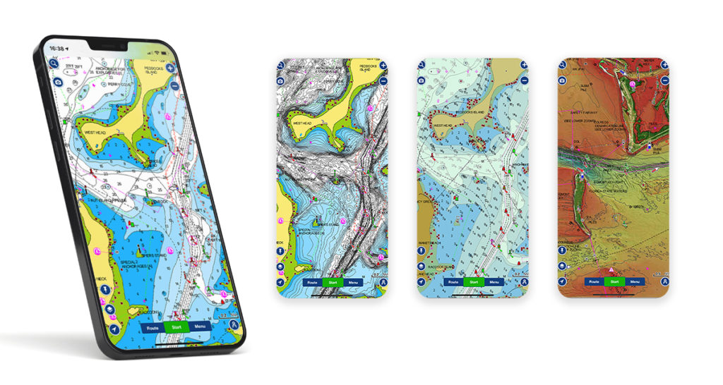
- Map with JOSM Remote
- Tidal Scale
- Aerial photo
- Coordinate Grid
- Elevation Profile
- Marine Profile (1:920.000)
- Marine Traffic
- Compass Rose
- Depth contours (beta)
- Water depth
- OpenCPN (Kap)
- Navico (Lowrance, Simrad, B&G)
- Trip Planner
- Bridges/Locks
- QUESTIONS? CONTACT US ->
- +1 239-888-0369

Plan your Boat Trip with this Boat Navigation Tool
- 29. July 2020
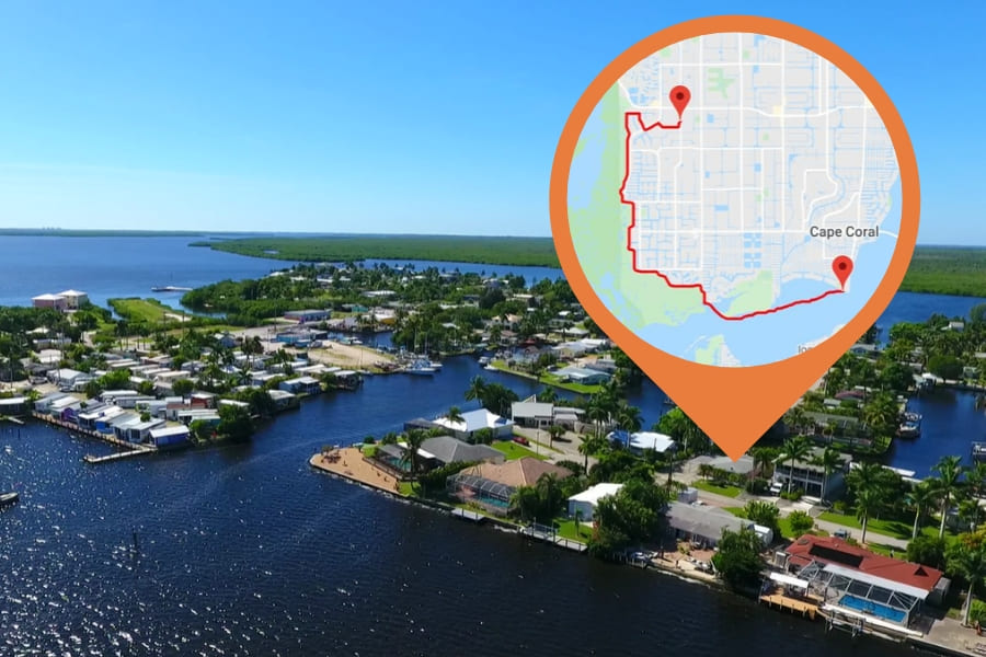
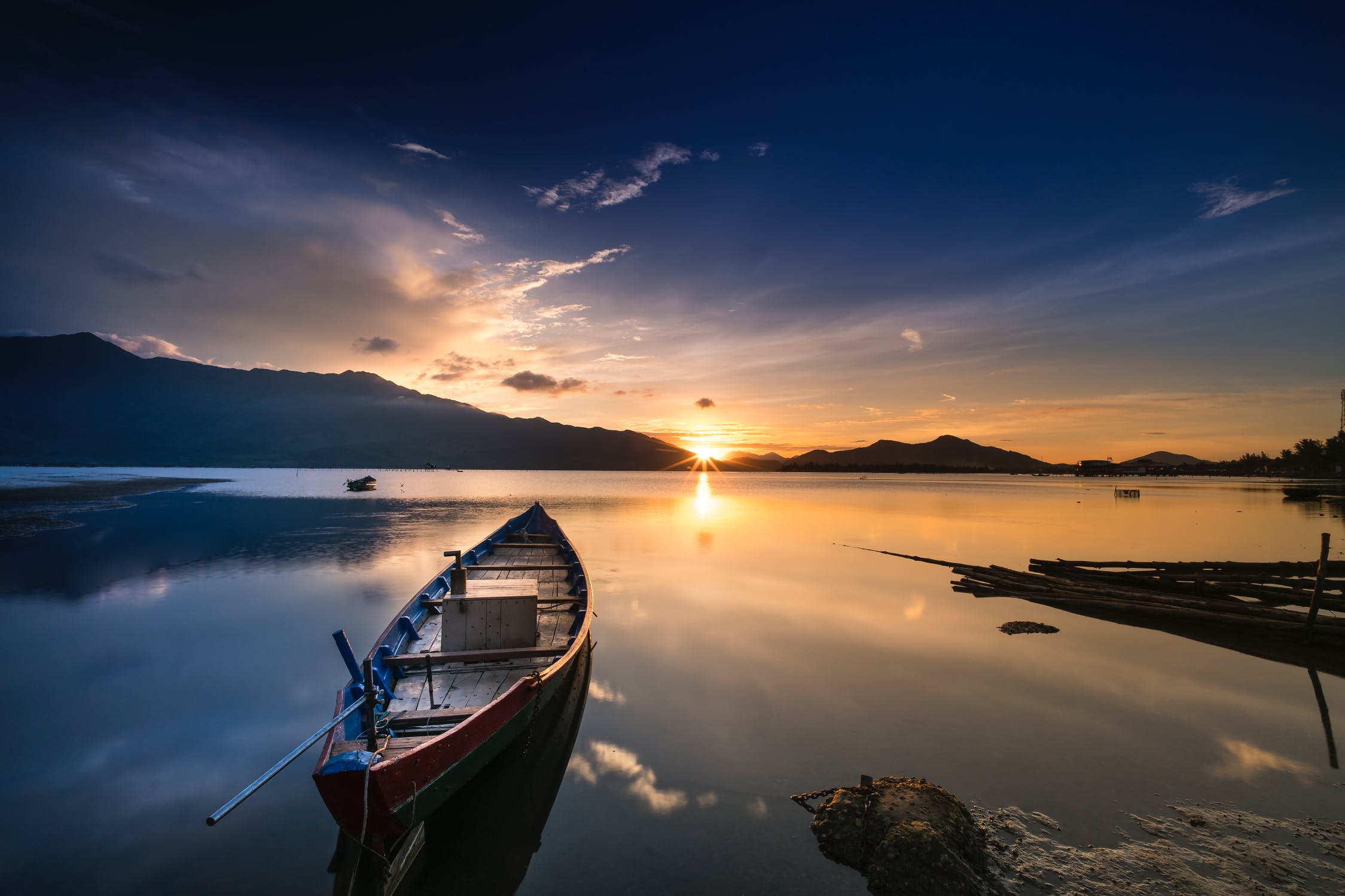
Boating is a popular way to explore Southwest Florida at your own pace and enjoy nearly unlimited freedom. However, a little planning is necessary before you can head for idyllic islands and other destinations near Cape Coral. If you want to know how long it takes to get to your destination and which route to take, this tool from our cooperation partner is your perfect choice.

Just follow these 3 simple steps:
- Type in your starting point , e.g. our boat dock (3637 Del Prado Blvd S, Cape Coral, FL 33904) in close proximity to open waters. Of course, we will also deliver the rental boat to your house if you want to start from there. In this case, just type in your address. Auto-correction will do the rest. Notice that the tool only works if your house is situated at the saltwater canal with access to the Gulf of Mexico.
- In the dropdown menu on the right, choose a destination for your boat trip. For example, you can display the fastest route to the Gulf of Mexico via Cape Coral´s canals by selecting Little Shell Island. Vacationers based in the Northwest of the city choose Matlacha Pass Bridge (Pine Island Road) instead. This option will show you the quickest way to the Gulf of Mexico.
- Click on “Show” to see the length of the route in miles, as well as the estimated travel time . Most salt water canals are designated “No Wake zones”. Therefore, the tool accounts for a boat speed of 5 mph.
Please note that these calculations from iboatmap.com at this moment are only a rough estimate to help you get an idea of the length and duration of your trip. Of course, we will provide you with a GPS navigation system . This way you can plan your route in more detail after you have rented your boat.
Disneyworld in Florida – Walt Disney World Resort in Orlando
Dear customer, Cape Coral is a paradise for everyone who would like to experience the adventure of" boating "on their vacation. Have you ever watched manatees and dolphins in the wild? This and much more is possible here in Florida without a boat license. We will help you take a trip on the water that will make your vacation an unforgettable experience. Let us advise you and take advantage of our diverse services at unbeatable prices. Contact us now so we can show you how the adventure becomes a reality. Bastian Riedel - General Manager Speed-Dock
Related posts
Your Boat License in Florida – Rules and Regulations
- 29. April 2021
iPad Boat Navigation Software – Your Companion On The Water
- 28. April 2021

FAQ – Frequently asked questions
- 27. April 2021
Join The Discussion
Cancel reply.
You must be logged in to post a comment.
Florida Boat Course

Vacation Rentals

Forgot Password
Please enter your username or email address. You will receive a link to create a new password via email.
Compare listings
Compare experiences.
IT WOULD BE NICE TO HAVE YOU ON BOARD;-)
SIGN UP FOR OUR NEWSLETTER AND RECEIVE $25 OFF FOR YOUR NEXT BOOKING
Thank you! Please enter the promo code FLORIDASTRONG in the booking process and get 20% discount on your booking!
There was an error while trying to send your request. Please try again.
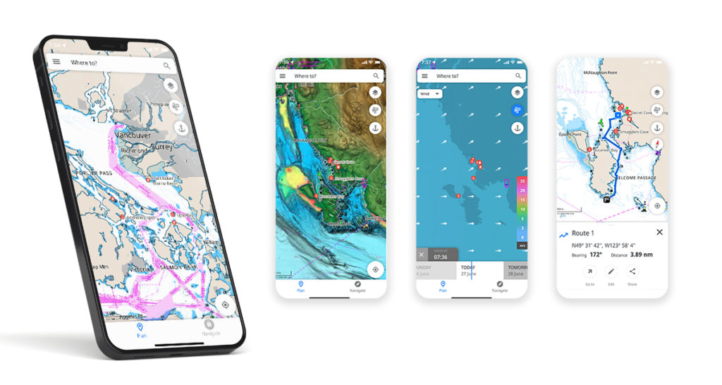
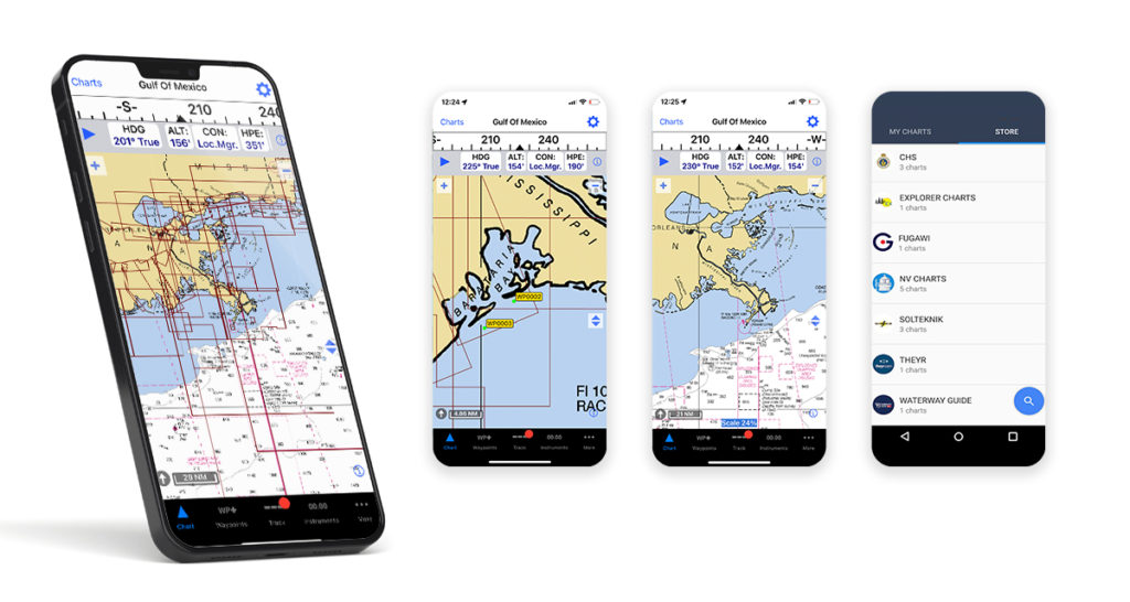
It's like Google Maps for boats.
Charts, weather, tides... Everything you need in one place.

Over 2 Million Downloads

4.7 out of 5 Over 5,000 5 Star Reviews

RAD NAV APP
I use Savvy Navvy daily for all my inshore fishing here in south Texas. Great for current conditions, including tides and wind direction. It’s like Google maps for boaters. Plan routes, mark your fishing spots and return to the dock in one piece. Every time! Great App 5 stars.
2 weeks ago during the heatwave, we were on the Solent and the temperature fried all our instruments including the GPS plotter. Thank god we had Savvy Navvy as it worked perfectly for the entire weekend and allowed us to do everything we wanted. People say these kind of apps aren’t meant to replace the instruments on board, well I can confirm that when they instruments on board all fail, this was an absolute lifesaver. Can’t wait to test it in other countries.
Great and simple to use
I sail with friends and families and this app is a great way to illustrate “dads” boring chart work through a much more teenage friendly platform. I use both for cross reference and find it pretty accurate. Considering the price of charts it is extremely good value.
Award winning navigation app

British Marine Excellence in Exporting Award 2024

Tech SouthWest MarineTech Business of the Year 2023
British Marine Business of the Year 2023
Great British Entrepreneur Awards Scale-Up of the Year 2022
Seedrs Entrepreneur of the Year 2019
It's free.
No credit card required., powerful tools to supercharge your navigation., savvy charts.
We licence UKHO, NOAA and other official hydrographic office charts from around the globe. Our designers build savvy charts from the ground up to show essential marine information with a clean and easy-to-view interface .

Over the Horizon AIS (OHA)
Enhance safety with greater awareness of vessel movements around you. Using your phone’s internet connection we stream vessel data such as speed, distance, MMSI, position, COG and destination.
GPS Active Tracking
View your live position and check your Course Over Ground (COG) and Speed Over Ground (SOG) in real time. Concentric circles around your position quickly show the distance between you and key features around you.

Marine Weather Forecast
We don’t expect you to be a metrologist to get the most out of your weather data. That’s why we use ECMWF technology to combine multiple weather forecasts for a more comprehensive forecast. Scroll through the coming days to view the changing wind direction, intensity and weather conditions.
Clouds and Rain Overlay
Use this overlay to view changing weather patterns within your area. This handy tool helps you avoid those pesky squalls and rain showers.

Intelligent Route Planning
Easily cross-check traditional navigation for greater peace of mind. We plan your route based on your departure time, boat details, chart data, wind, weather and tidal data, giving you a comprehensive passage plan.
Estimate Your Arrival Time
For those who don’t like to be late! Plot a route from A to B to get a quick and easy estimation of your distance to travel, fuel requirements and time of arrival. You can then share your chosen route with friends and family so they know when to expect you.

Fuel Efficiency
No one likes that feeling of potentially running out of fuel. That’s why our custom boat settings let you estimate fuel usage for your intended route based on your engine cruising speed and boat fuel efficiency.
Schedule departure time
Pick the best time to leave the dock for a better day on the water. Simply plot your route and scroll through the departure times to see the effect on your route, then choose the one you like best! Check out the demo .

And Many More Amazing Features!
Import markers.
Import your markers from other navigational tools to view all your saved locations within your savvy app. This ensures your valuable data will continue enhancing your boating experience while enjoying the savvy features you love most! Boat smarter, not harder.
Course To Steer
Savvy routing provides you with an automatic Course to Steer, taking into account tide, weather and chart data. Thanks to preview mode you can also review every stage of your journey before you set off.
Marina & Anchorage Information
Boat like a local with key information on tap! Select the marina and anchorage icons to view essential information on seabeds, weather protection, amenities, number of berths, maximum boat length, contact information, and more. Boat global, think local.
Save Your Favourite Locations
Love that secluded bay? Got a restaurant on that island you just don’t want to forget? Save pins at your favourite locations so you never forget those special places.
Anchor Alarm
Sleep like a baby with the savvy anchor alarm. This easy-to-use tool lets you set your safety parameters and happily sets off an alarm should you drift outside your comfort zone.
Satellite Mode
Get nosy when investigating the perfect spot with satellite mode. This handy overlay lets you take a more detailed look at marinas and anchorages so you can be sure you pick the best one.
Offline Charts & Weather
Wander where the WiFi’s weak with savvy offline. Download chart packs and weather data to your device so you can continue to use the features you love, even when you’re off-grid.
Export Routes
Plot your route with savvy navvy then export your route to a GPX file. This can be used with your onboard chart plotter for active navigation.
Share Routes with Friends
If you’d like your friends and family to meet you at your destination, or boat alongside, why not share your route so they can come along too? Sharing is caring as they say.
Dedicated Customer Support
We have a dedicated team on-call within the savvy navvy app to answer any questions you have, wherever and whenever you need us. We are not robots, our team love to help!
Discover How savvy navvy Makes Navigation Simple.
Watch our quick demo video of the main features of savvy navvy.

Frequently Asked Questions.
Have questions? We’ve answers. If you can’t find what you're looking for? Check out our knowledge base or feel free to get in touch
Chart Coverage.
Get access to all savvy charts, without paying anything extra. Check whether we have coverage in your boating area.
We partner with industry experts who share our passion and values. Get in touch if you'd like to collaborate.

Don’t Just Take Our Word for It.
Hear from our users, professionals and leisure boaters alike.

I’m learning navigation and after i’ve plotted my route I check with savvy navvy and can see whether there’s a big difference. It’s like having someone check your homework!
The main theme behind our conversation today has been around unravelling some of the mystique behind trips out into the maritime and coastal environment and the more tools that people are able to pick up and use to help them understand that environment the better.
Tools like the savvy navvy app, and the information provided through the application is unbelievably useful to help people on that journey.

An excellent way forward and definitely my number one planning and checking tool.
I signed up as a Founding Member as I could see the great benefits of savvy navvy. The data is out there and I believe this application will bring it together to provide a useful route planning tool.
Savvy navvy has the weather, it has the tide, it has the charts, it just does it for me.
Already a must-have navigation tool for sailors!
It’s a great idea to have an app like savvy navvy that enables people to cross-check their plans to ensure they haven’t made any mistakes.
A potential life-saving app. The product creation and subsequent business model development has been inspiring.
.jpg)
savvy navvy is hands down the best in the market, I have been using it since it first came out as Beta and that is why as soon I knew you guys were opening paid subscribers, I jumped in.
savvy navvy simplifies a whole range of different tasks that, as a skipper, you need to do. As soon as you test it, you just realise how easy it is to use, and how valuable it is!
I love it! First I do normal navigation on charts, then I use savvy navvy as a second check to give me a good idea of the best tacks to do, subject to tide, which I understand is coming soon! I even use it just to see the wind direction at home to assess what the mooring is like!
We Have Been Featured In.

Looking for something to wear?
We have a range of merchandise to suit the whole family, on or off the water.
Ready to Take Your Boating to the next Level?
Download savvy navvy boat app for iOS or Android today with a 14 day free trial.
Download savvy navvy boat app for iOS or Android today.
iOS & iPadOS.
Download savvy navvy, to start your free trial.
Download today, it’s free!

It's like Google Maps for Boats.
Charts, weather, tides... Everything you need in one place.
Over 1 Million Downloads
4.7 out of 5 Over 5,000 5 Star Reviews
RAD NAV APP
I use Savvy Navvy daily for all my inshore fishing here in south Texas. Great for current conditions, including tides and wind direction. It’s like Google maps for boaters. Plan routes, mark your fishing spots and return to the dock in one piece. Every time! Great App 5 stars.
by TeamTandem – Feb 3, 2023
2 weeks ago during the heatwave, we were on the Solent and the temperature fried all our instruments including the GPS plotter. Thank god we had Savvy Navvy as it worked perfectly for the entire weekend and allowed us to do everything we wanted. People say these kind of apps aren’t meant to replace the instruments on board, well I can confirm that when they instruments on board all fail, this was an absolute lifesaver. Can’t wait to test it in other countries.
by Gongolo270 – Sep 16, 2022
Great and simple to use.
I sail with friends and families and this app is a great way to illustrate “dads” boring chart work through a much more teenage friendly platform. I use both for cross reference and find it pretty accurate. Considering the price of charts it is extremely good value.
Hiltonvl.co.uk – Mar 9, 2023
Powerful features to supercharge your navigation., digital savvy charts™.
View clean and easy to use nautical charts on your phone, tablet or computer. We source data from hydrographic offices around the world and design the chart interface to be user-friendly. savvy members get access to all our chart data, wherever we have coverage. View our chart coverage .
Arrival Planning - ETA’s
Never miss a reservation or important deadline again with automatically generated estimated arrival times. With our boat route planner, you can quickly get an estimated distance, fuel requirement and time of arrival that takes into account weather forecasts, tide data, chart details and boat settings. Share your route with friends to let them know when you’ll be arriving.
Check Fuel Usage
Bespoke boat settings enable you to estimate the fuel required for your trip based on your boat engine cruising speed and estimated fuel efficiency. Adjust the settings for greater peace of mind when planning a day on the water.
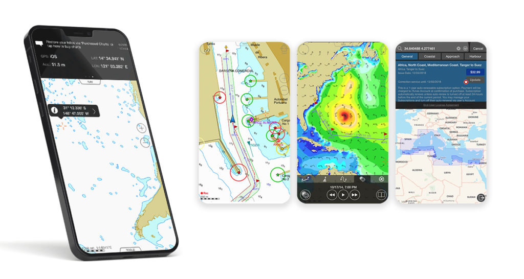
Quick and easy references make your trip hassle-free. Use savvy navvy’s boat GPS positioning mode to instantly see your location, view our savvy marine chart, as well as your course and speed over the ground.
Get instant access to tidal data from eight thousand tidal stations around the globe. savvy navvy’s tidal graph also gives you a quick visual reference for tidal highs and lows throughout the day. Tap the tidal streams toggle to get a visual overlay of tidal strength and direction on your digital marine map (chart).
Marine Weather Forecast
Drop a pin anywhere on your savvy chart™ to review forecasted temperatures, weather conditions and wind strength for that location. Use the weather graph to view the changing effects of the weather forecast throughout the day.
Plan Your Trip - savvy routing
savvy navvy has an inbuilt boat route planner. Set the location for your start and finish positions and the savvy routing™ algorithm will calculate the best route based on your boat settings, tide, chart and weather information. Routes can then be shared with friends or exported for use with your chartplotter.
Schedule departure time
See at a glance the best time to depart based on your route, wind & tidal conditions, see the demo.
Explore even more cool features
Automatic cts.
Our routes provide an automatic course to steer with a detailed preview of your route.
Marina & Anchorage
Plan the perfect lunchtime pit-stop or overnight stay by exploring detailed marina and anchorage information before you leave. Get detailed information on moorings, restaurants, fuel stations, and more.
Satellite Overview
They say it’s all in the detail. So why not take a closer inspection of secluded bays, marinas, anchorages and more by switching to satellite mode for a better look.
Offline Charts
Life is busy enough, so if you like to wander out of range of WiFi or phone signal, we get it. Before you go off-grid download your chart (or as some call it, a boating map) and weather information so you can continue to use all the savvy features you love when offline.
Export Your Route
If you would like to use your savvy route with your GPS chartplotter, that’s fine with us! Select “ Export route ” in the app to download a GPX file which can then be uploaded to the chartplotter of your choice.
Customer Support
With savvy navvy you’re never really boating alone. Our team are on-hand to help answer your questions if and when you need us, simply tap the intercom chat bot in the app and we’ll get right back to you.
Discover how savvy navvy makes navigation simple.
Watch our quick demo video of the main features of savvy navvy., view chart coverage.
Take a regular look at our chart coverage map to see the latest areas we cover.
Boat navigation made easy - Let’s get started...
The savvy navvy boating app is available on android or ios with a 14-day free trial., ios & ipados.
Download savvy navvy, to start your free trial.
Company The Crew Blog Podcast Newsletter Testimonials Ambassadors Contact
Product Pricing savvy Charts Terms of Service Privacy Policy Third Parties Help
© savvy navvy ltd Registered in England and Wales · 5 Elstree Gate, Elstree Way, Borehamwood, Hertfordshire, WD6 1JD, UK · reg: 10919572
The Top 5 Free Boating Navigation Apps

Gone are the days of getting hassled using old-school paper maps, inaccurate analog compass, and expensive gps trackers- our smartphones have become a handy all-in-one chart-plotter that makes our boating journey a thousand times more chill.
This article is a comprehensive review of 5 apps based on critical features needed for navigation and our own take on them, plus a comparison of each to help you decide which one to finally install.
Quick Overview
🥇 Over-all Champion: Navionics 🥈 Most User-Friendly Award: C-MAP 🥉 Best Value for Money Award: iSailor
Top Priority Features
While there can be a number of functions users may find interesting, we carefully identified the top 10 features that can make or break an app. These factors will highly contribute to the usefulness while on an actual trip, ability to provide information that can better prepare the you for your journey, safety, data management and affordability.
- Real time positioning – exactly locate yourself on a chart using GPS. Useful in estimating distance from a point or simply knowing exactly where you are and not get lost.
- Route Tracke r – start and stop record the track taken using GPS and display it on the chart. Gives Course over Ground (COG) and Speed over Ground (SOG). Log, review and export data for record keeping and future use.
- Route Planning – to create a path on a chart that can be followed using GPS, usually calculates distance between two or more points, ETA from point A to B, fuel needed. Useful before (to prepare necessary things) and makes navigation a lot easier. Just follow the arrow!
- Route Planning Incorporating Other Data – Modify cruising speed, ETA and fuel needed based on the live atmospheric/weather data, usually wind speed and direction.
- AIS Live – Use data (from other users or providers) to plot boat traffic and other activities on the chart, think about Waze. Increases situational awareness and safety.
- Download charts and Offline use – store a portion or the entire chart on your phone and use a number of features of the app even while offline, very useful at the middle of the sea where mobile data is unavailable.
- Chart Options and Data Overlay – Apply one or several layers of charts and data to show on the chart, e.g. depth, satellite, NOAA, wind direction, etc.
- Import/Export Data/ Data Synchronization – Download and upload waypoints, routes, tracks and use in other apps and softwares, sync data purchased to other devices like iPad, tablet and laptop.
- Weather Forecast – View changing wind speed and direction, precipitation, tides, and current data.
- Interface/User Friendliness – How easy is it to use for recreational boaters or more advanced users.
Many navigation apps can be downloaded for free and a lot of them have features that are accessible without a cost. However, in order to maximize their features such as unlocking AIS Live, weather forecast, downloading charts for offline use, a premium subscription is usually needed.
Some apps would allow users to use their phones’ GPS system to access basic functions such as real-time positioning, route tracking, even route planning at no cost, but these would usually require paying for the chart itself.
In general, these apps are very inexpensive (most of them less than $50 annually!), considering all the benefits we can get from them like saving dollars on unnecessary fuel consumption because of longer routes or the cost of repair in cases of accidents, and of course, our safety is priceless!
What is NMEA and is it really necessary?
NMEA stands for National Marine Electronics Association, this allows us to integrate electronic devices such as GPS, Sonar, radar, VFS radion and even boat speedometer, engine thermometer, oil pressure gauge, weather instruments, etc. In simpler terms, it lets our devices talk to each other.
Now the question is, is NMEA a must-have for boat navigation? While NMEA is undoubtedly useful in managing data we get from these separate devices, many recreational/small boats do not necessarily have a lot of sensors installed in them to the point that it’s unmanageable, so not having NMEA will not be a big issue for recreational boaters.
Some applications listed here do not have the NMEA integration feature but anyhow serve their purpose pretty well. You can still locate yourself, create a route, record your track, access weather forecasts, and most importantly, arrive at your destination safely even without it.
Charts or Maps?

All charts are maps but not all maps are charts . A map is a general term referring to a flat drawing of the Earth, or an area of it, let’s say a country. There are road maps that show networks of roads and passages, or topographic maps that show elevation. Meanwhile, there are also specialized maps that show great details of the bodies of water including depth or the water’s edge or any danger for navigation, these are called charts. Charts are what we need for boating !
Nautical Charts – Key to safe navigation and every boater should be familiar with. Through it, we will know the water depths, locations of dangers to navigation, locations and characteristics of aids to navigation, anchorages, and other features. Many, if not all, boating apps use this to let boaters plan the best route safely and economically.
Other Charts/Maps – Some apps would have more charts that you can use other than just nautical charts. Examples are satellite maps that show realistic images of the Earth’s surface, or Sonar imagery , which creates extraordinary bottom contour generated from water soundwaves.
Free vs. Paid? The amount of open-sourced data available helps the number of free charts grow, allowing many boaters to avoid spending extra on charts from big companies that make them, but remember that subscribing to these providers allows us to continuously get updates as well as ensure accuracy and reliability that we might not get from free sources.
Navionics Boating Marine & Lakes
Play/App Store Rating: 4.6⭐ No. of Downloads: 1.5M+
Cost: Free App with a two-week free trial, then subscriptions starting at $14.99 US.
Critical features
- Real time positioning
- Route Tracker
- Route Planning
- Incorporate Data on Route Planning
- Download charts and offline use
- Data overlay
- Import/Export Data/ Sync Data
- Weather Forecast
- User Friendly
Bonus Features
- Pan around and seamlessly zoom in and out
- Uses official unaltered NOAA charts
- Nautical and Sonar Charts that can be customized
- Multiple devices synchronization
- Auto-routing with dock-to-dock plans
- Easy-to-interpret, clearer view of bottom structure with Relief Shading and Sonar Imagery
- Marinas, mooring, fuel station, etc.
- More customization features for more advanced boater
- NMEA Integration expanded
Our verdict?
Well-designed and reliable, especially to recreational boaters who prefer simplicity and ease of use, the only downside is there’s not so much room for personalization. For accessing different charts including Sonar and NOAA, plus many advanced features such as auto-routing and data on marinas, mooring, fuel station, etc., the app subscription is relatively cheap.
Play/App Store Rating: 4.5⭐ No. of Downloads: 500K+
Cost: Free App with a two-week free trial and annual premium subscription at $60 US .
- Easy view that
- Long press to add a waypoint
- Worldwide chart personalization
- Contour customization
- High accuracy weather forecast
- High Resolution Bathymetry
- Auto-routing
- Fuel consumption estimate on plan
- Incorporate boat specs
- NMEA Integration
Very intuitive and easy to use with all the features needed by a boater for navigation. Value for money at US $60 that will let you plan trips more safely by increasing your situational awareness including high accuracy weather, AIS and high resolution bathymetry, and download charts to use offline.
Play/App Store Rating: 3.4⭐
Cost: Free App but other features only accessible with subscription, charts are paid starting at $4 US.
- Route Planning
- Weather Forecast
- Incorporate Data on Route Planning
- Displays just right amount of information
- Different features can be bought separately (save money)
- Weather forecast is downloadable
- Cheapest app that we’ve tested
- Availability on Google Play
- Simpler route planning
- Integrate weather data in planning routes
Being only available on App Store, Android users can now eliminate this app. Although, it is important to note that this is the cheapest app among all that we’ve tested. As it doesn’t have data integration on route planning, it’s NMEA compatibility is not actually maximized. Its interface is also better for iPad/tablet than smart phones.
Play/App Store Rating: 3⭐ No. of Downloads: 100K+
Cost: Free App with but other features only accessible with premium subscription at $39.99 US and charts are paid separately.
- Easiest creation of waypoints and showing enough information
- NMEA connection available
- Chart customization
- View several routes at a time
- Zooming out
- Select areas to download to save memory
Comprehensive navigation app providing necessary features for navigation on premium subscription. Making waypoints on this app is the easiest among all that we’ve compared. As it is NMEA compatible, data from the boat can be integrated to the app.
Play/App Store Rating: 4.4⭐ No. of Downloads: 100K+
Cost: Free App with NOAA Chart in the US, but needs to purchase other charts at different prices.
- Import/Export Data
- Weather Forecast
- Highly customizable with charts from different providers
- Customizable display
- Variety of charts that can be unavailable on other apps
- NMEA compatibility that provide extensive data
- Friendlier user interface as navigating the app can be challenging
- Synchronize with different devices to use purchased charts
Difficult user interface but highly customizable, recommended to more advanced boaters. Various charts available on purchase, which can be an advantage for those areas where charts are difficult to access, but note that you need to purchase them again whenever using a new device. It is also NMEA compatible with extensive data that can be integrated to the app.
Whether you’re just a beginner or already a seasoned boater, it is now almost impossible to start our engines without installing at least one app on our smartphones (others even couldn’t without a backup!). Are you ready to try these apps? Let us know what you think of them by leaving a comment below!
Google Play and the Google Play logo are trademarks of Google LLC. Apple logo® and App Store® are trademarks of Apple Inc., registered in the U.S. and other countries.

Karla Ceguerra
Related articles.
How to Pick Batteries for Your Boat
How to Pick the Right Boat Propeller
Boat Navigation Guide for Beginners
How to Launch a Boat by Yourself
Desktop App Login
Navigate, Explore, Connect.
Argo is a free easy-to-use navigation and social boating app that helps you find and route to new destinations, share local knowledge, and connect with other boaters..

4.9/5 • 5,000+ App Ratings
See What the Internet is Buzzing About!
Free to Download, Free to Use
With Argo you get easy-to-use navigation and routing, local boating knowledge, and social boating features all in one app!
Available on iOS and Android phones and tablets. Argo coverage includes the United States, Canada, and Caribbean.
Boating Made Easy
All the navigation features you need.

Navigation Capability
Find and route to new destinations within the U.S. and Canada with our clean, easy-to-use interface.

Customized Chart Data
You control what you see on your map. From map data to points of interest you are in control!

Community-Focused Boating
Get local boating knowledge and share your experiences with friends in your social feed.
Custom Autorouting
Plan your trip before you get out on the water. Simply let Argo know where you want to go or just tap the map and go. Argo will calculate the shortest and safest route customized based off your boat’s draft.

Captain’s Log
Automatically save places you’ve visited or trips you have taken. Add reports, places, photos and comments along the way. Then share with friends and family so they can see where you went or follow your same route.

Popular Destinations
Find the best spots to visit on or near the water with recommendations from other boaters. Places are continually updated with reviews, current pictures, descriptions and comments. These include local beaches, anchorages, marinas, restaurants, dock bars and more.

Real-Time Reporting
Get the latest on water hazards, weather and other potential issues to put you on the safest route. Create your own or comment on other reports to ensure accuracy. Customize your map so you only see pins that are most important to you.

Connect with Boaters
Connect with other boaters by adding your current friends and meeting new ones. Message them on the water, create or comment on a post, and share your trips and experiences with the boating community.

Get More With
Argo premium.
- All FREE Argo Features
- 7-Day Weather, Wind, Tides
- Offline Charts
- Custom Depth Shading
- Captain’s Log Reports
- Import/Export GPX Files
- Multiple Vessels
- Display Routes/Tracks
COMING SOON:
- AIS Traffic

See why Argo is trusted
By over 300,000 boaters, “best boating app”.
This marine navigation app is the easiest & amazingly totally free! Give it a try, I know you’ll agree the ease of use and clean interface will meet your needs.
“Perfect App!!”
Everything I really wanted for a simple GPS-based smartphone app with nautical chart integration. Highly recommend!
“User Friendly”
Love the app! Easy to learn, visually clear with several layout options for customizing info, terrain views, etc.
“Best New Boating App”
I love the intuitive autorouting function and my wife enjoys the social/community features for connecting with other boating friends.
“Best App for Daily Boaters for Just Occasional Fishers”
My father takes very frequent trips on his boat for the past 5-6 years and I showed him this app a few days ago & he LOVES it. He hasn’t stopped using it.
“Simple, Great Features, Excellent Support!”
It’s straightforward, uncomplicated, has a clean interface/display that isn’t overloaded, is easy to learn, and performs reliably.
“This App Beats All the Others!”
This app needs to be in every boaters arsenal. I absolutely love it. What a service the creator has done for us and for FREE!
New at Argo

September 11, 2024
Argo Boater Story: Argo Made Ms. Race Navigation Easy
Boater Community

July 30, 2024
Argo™ Releases App Update That Increases Loading Speed 10x

July 22, 2024
A Journey to Proper VHF Radio Etiquette
Boat Better Together
Argo is an easy-to-use navigation & boating app., partnerships.
Copyright © 2024 Argo Navigation, LLC. All Rights Reserved. Release Notes . Privacy Policy . Terms of Use .
- You are here:
- Great Loop Route
Great Loop Interactive Map
Find Harbor Hosts (look for the ring buoys), sponsors and "Best of the Loop" icons to see members' favorites in various categories. Our map also includes Waterway Guide markers.
Route Planner
Plan your sailing route.
Planning your sailing route is an important part of preparing for a sailing trip. There are various reasons why it is recommended to plan your route in advance. To begin with, choosing your sailing itinerary ensures your safety while out at sea. By researching and planning your route in advance, you may discover hazards such as rocks or shallow waters and avoid them, thereby keeping yourself and your passengers safe. Furthermore, choosing your route before your sailing trip permits you to visit all places you want and to make the most of your time aboard . This is particularly important if you are on a tight schedule or on a short trip.

Sailing Route Planner Tutorial
With our interactive boat route planner, you can plan your sailing trip down to the smallest detail. Our route planner tool allows you to choose your starting point and draw your desired sailing route. Once you're finished, the distance will be automatically calculated, and you can choose to have the sailing route sent to your email. Additionally, the boat route planner displays the coordinates of your starting and finishing points, so you can always know your exact location using your onboard instruments. Our boat route planner is the perfect tool to ensure the safety of your sailing trip.
Click on the video on the right and see an example of how to plan your own sailing route.

Don't lose your route , receive it on your e-mail.
Are you sure?
We use cookies to provide you with the best service on our website. If you stay on our website, you consent to our Cookies Policy .
Tell us about your dream holiday, and we'll make sure you get a personalised offer at the best price on the market.
Thank you for your message. We will get back to you as soon as possible.
We're looking forward to learn more about your dream holiday. The more info you send us, the more detailed and personalized offer we can provide.
You have succesfully submitted the details of your sailing trip. Your detailed and personalized offer is on its way.
Contact us to get some suggestions!
Thank you for your email. We will get back to you asap!
The 9 Best Marine Navigation Apps for Boaters
If you have a boat (or you're considering buying one) and a cell phone, you're probably interested in learning all about the best boating apps . And among the many available boating apps, marine navigation apps are some of the most useful. Top-tier marine navigation apps can turn your phone or tablet into a full-blown chartplotter, which means you have a valuable backup to the electronics at your helm and can carry your tech with you even when aboard small boats with no electrical systems.
Keep reading as we explain the features of each app and why the boating community champions it.
Navigating the Waters: Best Marine Navigation Apps for Every Boater
1. aqua map.
Aqua Map is a well-known marine navigation app that uses survey data from the U.S. Army Corps of Engineers (USACE) and Waterway Guide. With Aqua Map, you can easily access detailed charts, connect with other boaters, and make informed decisions on the water. Features include:
- Navigation : Offline charts, weather, tides, route planning, track recording.
- Integration : Connect boat instruments, AIS, and display data on the app.
- Safety : Anchor alarm with remote monitoring and marine weather forecasts.
- Community : Live sharing, chat, and data exchange with other users.
If you're looking for an app to combine route planning, navigation, and connecting with fellow boaters – Aqua Map checks all those boxes.
Price : Free with In-App Purchases and subscriptions available.
2. Argo
Argo is an excellent marine navigation app that allows you to make precise navigation and connect with fellow boaters. It's popular due to its position as a navigational guide made by boaters for boaters and a way to dive deeper into the nautical community.
Features include :
- Navigation : Safe and reliable route planning, custom and manual routes, track recording, and captain's log.
- Local Knowledge : Report and view hazards, local advice, marine life, and reviews.
- Social Platform : Connect and share experiences, real-time location sharing and messaging platform.
- Premium features : Offline charts, extended weather forecasts, customizable depth shading, multiple vessel support, and more.
From charting your course to connecting with others via their modern social platform – Argo offers everything you need for a fantastic day on the water. Price : Free with In-App Purchases.

3. C-Map
C-Map has a long history of creating digital charts and developing marine navigation apps – and is known to be a fan favorite. When designing this app, the goal was to make it user-friendly, simple, and easy to use. And that's one of the reasons why we love it! Boaters say it takes just 30 seconds to figure out how to accomplish essential navigational tasks like going from point A to point B. Features Include:
- Charting : Customizable charts, simple route planning, auto-routing, high-resolution bathymetry, and custom depth shading.
- Planning : Comprehensive weather and environmental forecasts.
- Safety & Community : AIS integration for boat tracking.
Price : Free with In-App Purchases and subscriptions available.
iNavX is one of the best marine navigation apps due to its easy-to-use interface and plethora of resourceful features. But our favorite part? It seamlessly integrates with many other chart providers – which is beyond helpful for boaters. Features Include :
- Chartplotter : Real-time GPS, chart control, instrument display.
- Navigation : Waypoint creation, route planning, track log, data import/export.
- Versatile Instrumentation : NMEA support, instrument connection, MacENC compatibility.
- Essential Toolkit : Weather, tides, alarms, search, and more.
Sailors and fishermen love iNavX for its reliable charts and ability to do more than simple navigational tasks with hundreds of advanced features. Price : Free with In-App Purchases and subscriptions available.
5. KnowWake
Think of KnowWake live your Google Maps or Waze for your car – but for your boat. This marine navigation app covers 350+ rivers and lakes inland and coastal waterways – all through real-time user-generated data.
- Real-time boat navigation app for coastal and inland waterways.
- User-generated content provides points of interest, hazards, and marine life sightings.
- Wake Zone identifier indicates safe boating speeds based on color-coded zones.
- Community-driven platform for sharing information and experiences.
With KnowWake, users can easily navigate waters and locate various local businesses, including eateries, marinas, fuel stations, boat launches, dive spots, snorkeling spots, and more.
Price : Free.
6. Navionics
Navionics lays claim to being the most popular boating app available, and its navigational features and functions are comprehensive. In fact, it offers many features that some modern chart plotters can't match! Features Include :
- Charting and Navigation : Accurate nautical charts, high-definition bathymetric maps (Sonarchart™), dock-to-dock auto-routing, and customizable map display.
- Community : Real-time updates from fellow boaters, sync data across multiple devices, and connect the app with compatible plotters.
- Environmental : Detailed weather forecasts and tide predictions.
Boaters and anglers love the app's simplicity and detailed nautical charts covering large portions of the world. Price : A 15-day trial comes free, then uses a subscription model.
7. OpenCPN
Another of the best marine navigation apps is OpenCPN (Chart-Plotter Navigation), which uses GPS software for people exploring open waterways. Boaters cherish it because it was crafted by sailors who put it to the test during their own adventures, resulting in high-quality chart-plotter software.
Features Include :
- Charts & Weather : Robust worldwide charts and GRIB/GRIB2 weather data input and display.
- Navigation : Route planning with tidal support, weather routing plugin, waypoint navigation, and autopilot output support.
- Safety : AIS target tracking and collision alerts, MOB alarm with tracking, and anchor watch/alarm.
Whether you're looking to use it underway or as a planning tool , Open CPN is consistently a top-runner for the best marine navigation apps.
8. Ramp Assist
Simplify your boat launching with Ramp Assist , the user-friendly app that makes launching and retrieving boats at ramps a breeze for all experience levels. Focused on safety and convenience, Ramp Assist streamlines the entire process, reducing stress and maximizing efficiency. Key Features :
- Ramp Locator : Discover and bookmark the best ramps nationwide with satellite views and up-to-date information.
- Ramp Details : Access ratings for cleanliness, difficulty level, and available amenities like parking and restrooms.
- Ramp Traffic : Monitor real-time boat ramp traffic and occupancy levels using satellite data and AI.
- Weather & Tide Monitoring : Get alerts for current weather conditions and tide levels at your chosen ramp.
- Trailering Assis t: Receive AI-driven guidance for safely loading your boat, with real-time feedback on distance, angle, and speed.
Pricing : Free with in-app purchases available.
9. Wavve Boating
Wavve Boating came onto the marine navigation app scene back in 2018 and has become a staple for many boaters and fishermen across the U.S. Like many of the others, it also features a community-based aspect to share routes and experiences with friends.
- Charts : Custom depth data, extensive chart library, real-time depth updates, and tide predictions.
- Weather : Multi-day forecasts with wave height and visual warnings for adverse conditions.
- Navigation : Route planning, trip recording, auto-routing with obstacle avoidance.
- Community : Connect with other boaters and discover popular boating spots.
Users especially love that this marine navigation app updates depths with tide changes, and it's known to have a user-friendly interface.
Price : Free trial for 14 days – subscription-based app.
Marine Navigation Apps: Upgrade Your Boat Day with Technology
When choosing a marine navigation app, make sure it has charts for your location, is affordable, and has all the safety features you need for your trip. All these above are our favorites, but more and more are popping up on the marketplace daily! And hey, you anglers, wait a sec – don't put that phone back into your pocket just yet because it's good for more than just navigation when you're out fishing . Also, check out the Best Apps for Fishing to catch more fish the next time you hit the water.

Join Our Newsletter!
Get community news, buying bargains, and how-to guides at your fingertips.
It's like Google Maps for boats.
Charts, weather, tides... everything you need in one place.
Over 10,000 downloads
4.6 out of 5 stars
“When I found myself at night and in unfamiliar waters, I had one friend checking the water depth with a pole and another friend looking for a boat nav app. Luckily we found Sea Drive. We were able to navigate home and I've been a Sea Drive user ever since.”
It really is like Google Maps for boating!
Depth and soundings are accurate, works well off the coast. It's the best water nav app I found.
Simple & intuitive
Sea Drive is dead simple to use and has free chart data and offline downloads. Finally a modern boat navigation app!
Fantastic App
I use Sea Drive everyday fishing in the Long Island sound, usually around Block Island or Newport. Great for tides, winds, weather. I mark all my favorite fishing spots and use the live location sharing when my buddies are out on the water. Great app. 5 stars!
RAD NAV APP
Free US Charts
You already paid for charts with your tax dollars. Why pay twice? Sea Drive gives you unlimited access (both online and offline) to all NOAA charts.

Tides & Currents
Check tides and currents without an internet connection. Visualize tides and currents for years into the future (or past) at more than 3000 locations around the US.
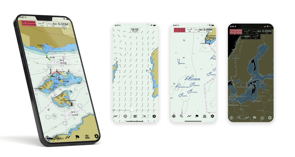
GPS Location
Turn on the GPS to instantly see your location on the chart. Sea Drive supports north up, course up, and heading up view modes. Your speed over ground is always available.

Offline Downloads
We know offline support is important, that's why it free. Download unlimited offline charts so you have access anywhere anytime.
Satellite Overlays
Enable satellite overlays for better navigational awareness and to help visualize your next destination whether it's a beach or a marina.

Turn on dark mode during twilight or overnight passagemaking to improve night vision and situational awareness.
Want sweet product updates?
Android & iOS updates, product announcements, hit the subscribe.
We never share your data. Read our Privacy Policy.
And more awesome features!
Drop a pin on a secret fishing spot or any point of interest. Share or export your markers.
Build routes and customize waypoint names. Navigate and view ETA, SOG, and bearing to the next waypoint.
Record, pause, and save your vessels location. Share and replay your routes or export a GPX file.
Distance Measurements
Use the caliper tool to measure the distance between points.
GPX Exports
Export routes, tracks, and markers as a GPX file for easy sharing with friends or compatible devices.
Heading Line
Orient your chart to course up mode and view a heading line overlaid on the chart.
Information Tool
Position the cursor and wipe up on the info panel to view details about anything on the chart.
Custom Depth Shading
Tailor the depth shading for your vessel type, be it a paddleboard or a deep keel sailboat.
Safety Depth
Set a custom safety depth and Sea Drive will show warnings about shallow areas.
Location Sharing
Share a link with friends for real time track updates, great for meeting up on the water.
Weather Data
Access weather forecasts including wind and swell/wave heights.
User Driven
We love feedback (especially the bad stuff). Contact us with requests and ideas. We might even build it!
Check Chart Charts
Sea Drive provides chart coverage for the US, the Great Lakes, and US Territories. We'll expand more globally in the future and we promise to keep chart data at as low of a cost as possible.
Ready to dive in? Start using Sea Drive today.
- Privacy Policy
- Terms of Use

How to Plan a Boat Trip

Table of Contents
Last Updated on September 15, 2023 by Boatsetter Team
There’s a saying among boaters that underpins every trip they plan: You can start or end where you want, and you can leave or arrive when you want, but you can’t always do both.
Watch the weather

When planning a boat trip , it’s important to understand that you and your guests will be in Mother Nature’s house. It doesn’t matter whether you’re heading out on the boat for a day, a week, or a month: Respect for the weather comes first.
If you have your heart set on arriving at, say, a particular waterfront restaurant, then you have chosen the “where.” The “when” will depend on factors such as wind, current, and any rain in the forecast, all of which can delay you by minutes, hours, or longer.
READ MORE: Dock and Dine Basics- 7 Tips for Success
Similarly, if you’re on a long-distance cruise and want to end in Florida on a certain day, you have chosen the “when.” But cruising conditions en route, you may end up having to make that landfall farther north in a place like Jacksonville , as opposed to farther south in the Venice of America, or as others call it Fort Lauderdale . The “where” becomes more of a variable.
Navigations

The next step, after understanding the general parameters of where you want to go on your boat trip, is taking a good, long look at a chart. You can lay eyes on a paper or an electronic chart, but either way, you want to familiarize yourself with where you’re going.
Make a note of any bridges you’ll have to contend with and note whether they open on a schedule or on demand. Check out the tide tables to see if there are easier or harder times of day to follow your chosen route.
Make any reservations you need to make at marinas along the way. In general, have a solid understanding of where you’re going before you set off to get there.
READ MORE: 7 Mindful Practices that Make Good Marina Etiquette
Boat maintenance

After that, the next step when planning a boat trip is ensuring the boat is in good working order. Luckily boats on peer-to-peer (P2P) platforms like Boatsetter undergo a vetting process to ensure safety and the best experience possible.
Still, it can’t hurt to be cautious, check all the equipment in the engine room, make sure power systems are fully charged, and triple-check gear such as personal flotation devices and first-aid kits. The last thing you want is to get underway on your boat trip and be unprepared in case of a problem.
What to pack

Next, you’ll want to make sure you have all the essentials you need for your boat trip— Is there enough water for everyone? Enough ice to keep it cold in the cooler? How about snacks? Towels? Hats? Sunscreen? These things may sound small and easy to “remember,” but are often forgotten. Feel free to use the checklist we’ve created when packing for your boat trip:
- Sunscreen (at least 30 SPF)
- Drinking water (Keep in mind pets if you plan on bringing them aboard.)
- Extra change of clothes
Avoid forgetting or overpacking: Check the boat listing for Add-ons like a cooler/ice chest, ice, snorkeling gear, and more !
Last but not least, get into the right mindset for your boat trip. Yes, it’s a bit of work to ensure everything is ready to go, but boating is supposed to be fun when it comes down to it. Start your boat trip with a smile, and get out there and enjoy the journey.
Boatsetter is a unique boat-sharing platform that gives everyone— whether you own a boat or you’re just renting — the chance to experience life on the water. You can list a boat , book a boat , or make money as a captain .
List your boat & start earning an avg. of $20K yearly with Boatsetter
Kim Kavin has been on boats in more than 50 countries and islands, including in the Caribbean, Mediterranean, South Pacific, Indian Ocean and Southeast Asia. She grew up learning to steer a ski boat and Hobie Holder at her grandfather’s lake house in New Jersey, and went on to spend time aboard everything from America’s Cup racing sailboats to submarines.
Kim is a PADI-certified scuba diver and animal lover who always enjoys a good, long look around a coral reef. Her award-winning writing and editing regularly appears in national marine magazines and on leading websites. In her early years, she was a Dow Jones editing intern and a graduate of the University of Missouri-Columbia School of Journalism. When she’s not writing, Kim can usually be found hiking northwest New Jersey’s beautiful park trails with her adopted shelter mutt, Ginger.
Browse by experience
Explore articles

5 Best Beaches in Malibu, CA

Planning Your Unforgettable Boat Proposal

7 Easy Ways to Increase Your Boat's Value
What Is Blue Friday?
My itinerary
This is a free demo version of our mapping software.
Create an account to save your current itinerary and get access to all our features.
Otherwise your data will be automatically deleted after one week.

- Visit Our Blog about Russia to know more about Russian sights, history
- Check out our Russian cities and regions guides
- Follow us on Twitter and Facebook to better understand Russia
- Info about getting Russian visa , the main airports , how to rent an apartment
- Our Expert answers your questions about Russia, some tips about sending flowers

Russian regions
- Altay republic
- Irkutsk oblast
- Kemerovo oblast
- Khakassia republic
- Krasnoyarsk krai
- Novosibirsk oblast
- Omsk oblast
- Tomsk oblast
- Tuva republic
- Map of Russia
- All cities and regions
- Blog about Russia
- News from Russia
- How to get a visa
- Flights to Russia
- Russian hotels
- Renting apartments
- Russian currency
- FIFA World Cup 2018
- Submit an article
- Flowers to Russia
- Ask our Expert
Omsk city, Russia
The capital city of Omsk oblast .
Omsk - Overview
Omsk is one of the largest cities in Russia, a major scientific, cultural, sports, transport, and industrial center. The administrative center of Omsk Oblast, it is the second most populous city in Siberia.
The population of Omsk is about 1,126,000 (2022), the area - 567 sq. km.
The phone code - +7 3812, the postal codes - 644000-644246.
Omsk city flag
Omsk city coat of arms.

Omsk city map, Russia
Omsk city latest news and posts from our blog:.
10 November, 2019 / Tomsk - the view from above .
3 July, 2016 / Omsk - the view from above .
20 October, 2012 / The bear at the gate .
2 August, 2012 / Omsk city from bird's eye view .
14 December, 2011 / Time-lapse video of Omsk city .
More posts..
History of Omsk
Foundation of omsk.
The need to build a Russian fortress on the banks of the Irtysh at the mouth of the Om River arose in connection with the steppe nomadic peoples. In particular, with the Oirats, whose tribes in the first decades of the 17th century began to appear within the borders of the Russian state being under the onslaught of their external enemies and as a result of internal civil strife. However, various foreign and domestic political problems of Russia hindered the development and defense of the South Siberian borders.
The situation changed only at the beginning of the 18th century, when the Russian conquest of Siberia intensified. Since Peter I paid great attention to geographical research in the south, the expeditions of that time combined socio-political tasks and tasks of scientific research.
One of such expeditions was led by the Russian military and statesman, associate of Peter I, Major General Ivan Bukhgolts. The goals of the expedition, numbering about 3,000 people, were to search for ore and gold deposits, the discovery of trade routes to India and China, as well as the construction of towns on the Irtysh River.
The expedition left Tobolsk to the south along the Irtysh in July 1715. In the spring of 1716, after a conflict with the Dzungars in the north of today’s Kazakhstan, the remnants of the expedition (about 700 people) withdrew to the mouth of the Om River, where they laid a new fortress named Omsky ostrog (fortified settlement).
According to the census of 1725, 992 people lived in the fortress, in 1742 - 1,092 people. From the first years of its existence, it served as a place of exile for prisoners. After serving hard labor and imprisonment, a lot of them stayed in Omsk for permanent residence.
More Historical Facts…
Omsk in the second half of the 18th century
The ethnic composition of the region’s population was formed in the process of settling the territory. Russians, Germans, Ukrainians, Poles, Belarusians, and representatives of many other nationalities were sent here to serve or were exiled. The indigenous people of the region were the Siberian Tatars and Kazakhs, who switched to a sedentary lifestyle.
The foundation of the second Omsk fortress took place in 1762. The first fortress, although it occupied a favorable geographical position, was wooden and, by the middle of the 18th century, it was dilapidated. In 1765, new stone fortifications were constructed. The first stone structure of the fortress was the Resurrection Military Cathedral, built in 1773 and preserved to this day.
In the end of the 18th century, the Omsk fortress was one of the largest structures in the eastern part of the Russian Empire, its area was more than 30 hectares. In 1782, it was transformed into a town named Omsk within the Tobolsk Governorate. In 1785, the coat of arms of Omsk was approved.
Omsk became the center of management of the Siberian transport routes and the Siberian Cossack army, which not only guarded the South Siberian borders, but also made a huge contribution to the economic development of the steppe expanses of Kazakhstan, the annexation of Central Asia to the Russian Empire.
Omsk in the 19th century
The fire of 1819 destroyed almost half of the town including the archive and the magistrate of Omsk with all the first archival documents. Therefore information about the life of Omsk in the 18th - early 19th centuries is scarce and fragmentary. In 1825, the population of the town was about 9,000 people.
In 1829, the town’s development plan was approved. It was made by the famous Petersburg architect V.I. Geste, who took the city of St. Petersburg as a model with its wide avenues, huge neighborhoods, fountains, cast-iron bridges, and an abundance of green spaces.
The composition of the population of Omsk was not quite usual. In the middle of the 19th century, since Omsk was the center of the military and civil administration, the proportion of the military in the local population reached about 60%.
Fyodor Dostoevsky (one of the greatest psychological novelists in world literature), who served a term of hard labor in the Omsk prison in 1850-1854, in a letter to his brother gave Omsk the following description: “Omsk is a disgusting town. There are almost no trees. In summer, heat and wind with sand, in winter, a snowstorm. I have not seen nature. The town is dirty, military and highly depraved.”
By the second half of the 19th century, Omsk in its development outstripped many steppe towns and became not only an administrative, but also a commercial and industrial center. In 1861, in Omsk, there were 2,122 houses (31 stone houses), 34 factories and plants, about 20 thousand residents.
In 1892, the construction of the Trans-Siberian Railway began, which gave a new impetus to the economy of Siberian towns and positively influenced Omsk. The development of the Trans-Siberian Railway caused an increase in the urban population due to migrants who came to work from the central part of the Russian Empire. According to the 1897 census, 37.3 thousand people lived in Omsk. The town had 14 streets with a total length of more than 140 km and 13 squares.
Omsk in the first half of the 20th century
The beginning of the 20th century was a time of great changes for Siberia. Mass peasant colonization caused a sharp leap in the development of the region’s economy, primarily its agrarian sector, and the Trans-Siberian Railway ensured the inclusion of the local economy in the system of the All-Russian and European markets.
Due to its favorable economic and geographical position - at the intersection of the railway and the Irtysh River, in the middle of a vast agricultural territory - Omsk quickly turned into a large transport, trade and industrial center of Western Siberia and Governor-Generalship of the Steppes (Eastern and Central Kazakhstan).
Wholesale trade in bread, butter and other agricultural products was concentrated here. Omsk also became one of the industrial, social and cultural centers of Western Siberia. By 1903, the city’s population grew to 60 thousand people. In 1914, it had about 134.8 thousand residents. Omsk became the most populous city in Siberia.
During the Civil War on the territory of the former Russian Empire, from June 1918 to November 1919, Omsk was the residence of the Supreme Ruler of Russia, Admiral Alexander Kolchak, who declared this city the capital of white Russia opposing red Russia of the Bolsheviks. Soviet power was finally established in the city in 1920.
In the summer of 1921, an event took place that had a decisive impact on the cultural and economic life of Omsk. The functions of the administrative center of Siberia were transferred from it to the city of Novonikolaevsk (future Novosibirsk). In 1934, Omsk became the administrative center of a separate Omsk Oblast.
Over the years of industrialization, Omsk became one of the largest centers for agricultural engineering in the USSR. The metal-working industry also developed at a rapid pace. In 1939, Omsk numbered more than 288 thousand people.
During the Second World War, about 200 industrial enterprises were evacuated to Omsk, as well as 60 hospitals, dozens of educational institutions, theaters, museums, and hundreds of thousands of refugees.
Omsk after the Second World War
In the post-war years, new enterprises were put into operation in Omsk, all existing factories and plants were reconstructed and expanded. The industrial potential of the city was also strengthened by the Omsk oil refinery, the largest in the country. In connection with the rapid development of industry, especially petrochemical enterprises, the ecological situation deteriorated. The concentration of harmful substances in the air sharply increased. In 1964, the population of Omsk was about 702 thousand people.
In the 1970s-1980s, Omsk developed rapidly. In 1975, the city’s population exceeded 1 million. The most pressing problem was the ecological situation. Omsk was in the top 10 cities of Russia in terms of environmental pollution. Another problem that required an immediate solution was the development of passenger transport. The capacity of Omsk streets was exhausted, and therefore the construction of the subway became an urgent issue.
The economic crisis that gripped Russia after the collapse of the USSR had a negative impact on the economy of Omsk and the region as a whole. There was a significant decline in industrial production, construction volumes fell, and unemployment rose. A lot of organizations of the defense complex, research institutes, and design bureaus found themselves in a deep crisis without the state defense order.
The share of mechanical engineering and metalworking, light industry, and, to a lesser extent, chemical and petrochemical, forestry and woodworking industries decreased. At the same time, the share of the fuel industry, energy, and construction materials industry began to grow.
In the 2000s, Omsk again became one of the most important economic centers of Western Siberia with a developing mechanical engineering, petrochemical industry, various branches of the woodworking, construction industry, and a highly productive agro-industrial complex. In recent years, Omsk has also acquired the features of one of the largest Siberian centers of entrepreneurship and banking/financial activities.
Architecture of Omsk

On the street in Omsk
Author: Tim Brown

Yak-9 fighter aircraft in front of the aerospace engineering company Polyot in Omsk

The Omsk Cadet Corps
Author: Stanislav Katsko
Omsk - Features
Omsk is located in the south of the West Siberian Plain at the confluence of the Om River into the Irtysh, about 150 km from the border of Russia with Kazakhstan. About 60% of all residents of Omsk Oblast live in Omsk. The City Day of Omsk is celebrated on the first Saturday of August.
The city’s coat of arms is very similar to the first coat of arms of Omsk approved by Empress Catherine II in 1785. It depicts a part of the brick fortifications, which symbolizes the reason for its foundation as a fortress and the center of the Siberian defensive line.
Omsk belongs to the temperate climatic zone with a continental climate of the forest-steppe of the West Siberian belt. It is distinguished by an abundance of sunlight. The average air temperature in January is minus 16.3 degrees Celsius, in July - plus 19.6 degrees Celsius. The highest wind speeds are observed in winter and spring, which is the reason for frequent snow and dust storms.
In the past, the ecological situation in Omsk was very unfavorable. Since 2011, the city’s environmental development rating has increased significantly. This was the result of large-scale modernization of many large industries (including the Omsk oil refinery). Today, road transport is the main source of air pollution in the city.
The level of pollution of the Omsk rivers - Irtysh and Om - remains consistently high. Swimming in them is prohibited. While industrial effluents are becoming more environmentally friendly, sewers are releasing waste products including diesel fuel and petroleum products into the rivers. Dust raised by dust storms is also a serious problem for the city as it contains a lot of harmful substances including lead.
The city’s industry is based on oil refining, petrochemistry, chemical industry, mechanical engineering (production of aerospace equipment, armored vehicles, agricultural equipment). Omsk is a major transport junction - the Trans-Siberian Railway runs through the city from west to east, and the navigable Irtysh River crosses it from south to north. Omsk Airport offers regular flights to Moscow, St. Petersburg, Novosibirsk, Tyumen, Surgut, Yekaterinburg, Krasnoyarsk, Salekhard, Kazan, Krasnodar, Sochi.
The unfinished subway of Omsk has become famous in Russia thanks to its only one fully built station. Its construction began back in 1992. However, due to funding problems, the completion of the first line was postponed numerous times. In 2019, it was finally decided to permanently stop construction. For local residents, because of the long wait for the completion of the construction, the Omsk metro symbolizes unrealizable hopes, they talk about it with irony.
In Omsk, there are practically no buildings higher than 50 meters, according to this parameter it is one of the lowest cities with a population of over one million. 130 architectural monuments are concentrated in the central part of the city, almost half of the total number.
Main Attractions of Omsk
Dormition Cathedral - the largest church in Omsk located in the very center of the city. The original church was built in 1891-1898. In 1935, it was completely destroyed. In 2005-2007, an exact copy of the building was restored in its original place. This is one of the most beautiful buildings in Omsk. At night, the building is illuminated and looks especially majestic. Tarskaya Street, 7.
Irtysh Embankment - the main walking street of Omsk with a picturesque view of the Irtysh River. Built in the middle of the 20th century, the embankment was reconstructed in the 2000s. You can walk along the alley on foot, ride rollerblades or a bike.
Merchant Batyushkin’s Mansion (1902). This architectural monument is located on the Irtysh Embankment. It is also known as the Kolchak’s House because Alexander Kolchak, the Supreme Ruler of Russia, lived in this building in 1919. One part of the building is occupied by the registry office of the Central District of Omsk. The Center for the Study of the History of the Russian Civil War is also open here. Irtyshskaya Naberezhnaya Street, 9.
Omsk State Museum of History and Local Lore - one of the oldest museums in Siberia and Russia founded in 1878. In total, this museum has over 200 thousand various objects of cultural, historical and artistic value. The museum is especially proud of such exhibits as the cast-iron figures of the Chinese lions Shi-Tzu, presented to the museum from China in 1895, as well as the skeleton of a woolly mammoth almost 3 meters high. Lenina Street, 23?.
Omsk Regional Museum of Fine Arts named after M.A. Vrubel - one of the largest museums of fine arts in Siberia. It has collections of foreign and Russian art from antiquity to the present day. In total, there are over 22 thousand works by painters, graphic artists and sculptors, as well as more than 1.5 thousand rare folios.
Walking through the exhibition halls, you can admire the canvases of Shishkin, Aivazovsky, Surikov, Repin, Serov, Vereshchagin. The exhibition of rare icons dating from the 17th-20th centuries is of constant interest among visitors, as well as a unique collection of jewelry made of precious metals found in the Scythian and Sarmatian burial mounds. Two buildings of the museum are located at Lenina Street 3 and 23.
In November 2019, a new exhibition was opened in a historical building at Muzeynaya Street, 4 - the exhibition of art of the 20th-21st centuries. The Hermitage-Siberia Center is located here too - the first representation of The State Hermitage Museum (the second-largest art museum in the world) beyond the Urals.
Chokana Valikhanova Street - a pedestrian street located in the historic part of Omsk. The street is decorated with abstract architectural forms, flower beds, wrought-iron lanterns. The walking area ends with an observation deck with a picturesque view of the Irtysh River.
Museum of Kondraty Belov . The museum of this landscape painter born in Omsk can be found in a picturesque wooden house, which is considered one of the most interesting architectural monuments of Omsk. The exposition tells about the life and work of Kondraty Belov, as well as about the history of the building itself.
In total, this museum has about 700 exhibits. The permanent exhibition also includes works by Kondraty Belov’s son Stanislav and paintings by some other local artists. In addition, temporary exhibitions of contemporary Omsk artists are regularly held here. Chokana Valikhanova Street, 10.
Plumber Stepanych Monument - an unusual sculpture located in the center of Omsk, which you can literally stumble upon while walking along Lenin Street between the houses #12 and #14. Leaning out of the hatch, the plumber is depicted as realistic and life-size as possible. It is among the most photographed monuments in Omsk. There is a similar sculpture in Bratislava, the capital of Slovakia.
Lyuba Monument . This sculpture, located on the opposite side of Lenin Street from the monument to the plumber Stepanych, is especially loved by Omsk residents and tourists, who love to be photographed against its background.
This beauty in a lace dress with a neckline and a crinoline sitting on an openwork bench and reading a novel had a real prototype - Lyubov (diminutively Lyuba or Lyubasha) Gasford, the wife of the Governor-General of Siberia, who lived in Omsk in the 19th century and died at a young age due to illness. One of the streets of Omsk and the park are named in her memory. She is a local symbol of femininity and beauty.
Omsk Fire Tower - a picturesque architectural monument built at the beginning of the 20th century. Inside the tower there are museum expositions dedicated to the local fire brigade and the history of tower construction. Internatsionalnaya Street, 41?.
Park of Culture and Rest named after the 30th anniversary of the Komsomol - a popular place for walks, recreation and entertainment of Omsk residents and tourists, which has retained “the spirit of the Soviet era” in its name. Today, on an area of 73 hectares, several zones have been organized, various types of recreation are presented. There are walking alleys, ponds, water activities, for example, riding on hydro-scooters.
The ice town is open in winter, the Return of the Dinosaurs exhibition - in summer. The “House Upside Down” exposition is also popular with tourists. This park is a place for mass festivities, city celebrations and events. Maslenitsa, Christmas, City Day, and other holidays are celebrated here. Maslennikova Street, 136.
Natural Park “Bird Harbor” - a specially protected area located on the path of bird migration in the central part of Omsk. During autumn flights, up to 3 thousand birds stop here for rest. It is a great place to enjoy nature, walk along the eco-trail, and observe the life of birds. The park is situated in the floodplain on the left bank of the Irtysh River next to the Victory Park on Yeniseyskaya Street.
Omsk city of Russia photos
Pictures of omsk.

Bogdan Khmelnitsky Monument in Omsk

Lenin Monument in Omsk
Churches of Omsk

Chapel of St. George in Omsk

Cathedral of the Exaltation of the Holy Cross in Omsk

Cathedral of the Nativity in Omsk
Sights of Omsk

Fountain with frogs in the park next to the main building of the Agricultural Academy in Omsk
Author: Alexey Pavlov

Church of St. Nicholas in Omsk

Exaltation of the Holy Cross Cathedral in Omsk
Author: Stanislav Vosinsky
The questions of our visitors
- Currently 2.96/5
Rating: 3.0 /5 (215 votes cast)
IMAGES
VIDEO
COMMENTS
MarineTraffic Live Ships Map. Discover information and vessel positions for vessels around the world. Search the MarineTraffic ships database of more than 550000 active and decommissioned vessels. Search for popular ships globally. Find locations of ports and ships using the near Real Time ships map. View vessel details and ship photos.
Calculate the distance, fuel consumption, and cost of your next boating trip. Boatbookings have created the leading online yacht charter route planner, distance and fuel calculator, so you can see your exact cruising plan and itinerary in unrivalled detail. See how far it is between each place of interest and all the islands and towns you will ...
Explore the free nautical chart of OpenSeaMap, with weather, sea marks, harbours, sport and more features. Download for offline use.
Get local and national boating conditions. Plot your course with interactive nautical charts complete with weather radar, buoy reports, wind speed, wave heights, and marine forecast.
It can still be potentially useful in planning a sailing or boating route, however. First off, you can use Google Maps, including its satellite view, to take a look at an area you plan to be boating. You might be able to see where different lakes and rivers are located and identify any resources that are available on land nearby, from docks and ...
Ad. Just follow these 3 simple steps: Type in your starting point, e.g. our boat dock (3637 Del Prado Blvd S, Cape Coral, FL 33904) in close proximity to open waters. Of course, we will also deliver the rental boat to your house if you want to start from there. In this case, just type in your address. Auto-correction will do the rest.
RAD NAV APP. I use Savvy Navvy daily for all my inshore fishing here in south Texas. Great for current conditions, including tides and wind direction. It's like Google maps for boaters. Plan routes, mark your fishing spots and return to the dock in one piece. Every time! Great App 5 stars. by TeamTandem - Feb 3, 2023.
Last Updated on May 19, 2024 by Boatsetter Team. For almost everything you do today, there's an app that will support, enhance or complement that activity. Recreational boating is no exception, and there are dozens of boating apps to help you enjoy time on the water.. Arguably, marine navigation apps are some of the most common—and the most useful—available to boaters today, with a range ...
Plan Your Trip - savvy routing. savvy navvy has an inbuilt boat route planner. Set the location for your start and finish positions and the savvy routing™ algorithm will calculate the best route based on your boat settings, tide, chart and weather information. Routes can then be shared with friends or exported for use with your chartplotter.
Cost. Free App with a two-week free trial, then subscriptions starting at $14.99 US. Free App with a two-week free trial and annual premium subscription at $60 US. Free App but other features only accessible with subscription, charts are paid starting at $4 US.
Free to Download,Free to Use. With Argo you get easy-to-use navigation and routing, local boating knowledge, and social boating features all in one app! Available on iOS and Android phones and tablets. Argo coverage includes the United States, Canada, and Caribbean. Download for Free.
The Great Loop interactive map on America's Great Loop Cruisers' Association's (AGLCA) website shows the route with markers for Harbor Hosts, sponsors, members' favorite places and things to do and Waterway Guide markers for anchorages, bridges and locks.
Additionally, the boat route planner displays the coordinates of your starting and finishing points, so you can always know your exact location using your onboard instruments. Our boat route planner is the perfect tool to ensure the safety of your sailing trip. Click on the video on the right and see an example of how to plan your own sailing ...
Navigating the Waters: Best Marine Navigation Apps for Every Boater. 1. Aqua Map. Aqua Map is a well-known marine navigation app that uses survey data from the U.S. Army Corps of Engineers (USACE) and Waterway Guide. With Aqua Map, you can easily access detailed charts, connect with other boaters, and make informed decisions on the water.
Sea Drive provides chart coverage for the US, the Great Lakes, and US Territories. We'll expand more globally in the future and we promise to keep chart data at as low of a cost as possible. Ready to dive in? Start using Sea Drive today. Your personal lighthouse. Modern marine navigation. Sea Drive is a chartplotter app with free charts, tides ...
Marine Traffic AIS Tracking World Map
Watch the weather. When planning a boat trip, it's important to understand that you and your guests will be in Mother Nature's house. It doesn't matter whether you're heading out on the boat for a day, a week, or a month: Respect for the weather comes first. If you have your heart set on arriving at, say, a particular waterfront ...
Add your travel destinations on a map, select your transport modes, visualize and share your itinerary for free. My itinerary This is a free demo version of our mapping software. Create an account to save your current itinerary and get access to all our features. ...
TRAVEL HOWEVER YOU LIKE. With almost 100 different modes of transport to choose from, you'll almost certainly be able to find the one you need. Sophie Müller . Pilot Linda . IMPORT GPX. Our app lets you import GPX tracks from almost any tracker. Record your route and send the track to TravelBoast to get a beautiful map.
Route maps are available online. A ticket for a bus, trolleybus, or tram costs RUB22 and a ride in a marshrutka costs RUB25. ... this boat is the only access to the outside world. Barnaul (16 hours by train or a 1.5 hour flight) is the gateway to the Altai mountains and national parks. Kazakhstan is accessible by train - Petropavlovsk (4 hours ...
Omsk is one of the largest cities in Russia, a major scientific, cultural, sports, transport, and industrial center. The administrative center of Omsk Oblast, it is the second most populous city in Siberia. The population of Omsk is about 1,126,000 (2022), the area - 567 sq. km. The phone code - +7 3812, the postal codes - 644000-644246.
It shows a couple sitting and... 10. Omsk State Museum of History and Regional Studies. 52. History Museums. Established in 1878, this museum safeguarded valuable collections during World War II and, after the war, expanded its holdings to reflect the region's rapid social development, economic achievements…. 11.
Things to Do in Luzino, Russia: See Tripadvisor's traveler reviews and photos of Luzino tourist attractions. Find what to do today, this weekend, or in September. We have reviews of the best places to see in Luzino. Visit top-rated & must-see attractions.