- The Researcher
- Podcast Interview: The Lost Sea
- The Exodus Enigma
- The Date of the Exodus
- The Sojourn in Egypt

Map of the Exodus from Egypt
- Proof of Mount Sinai in Arabia
- Exodus Mysteries Book
- Mount Sinai and the Apostle Paul
- Was Mount Sinai a Volcano?
- The Sea of the Exodus
- Wind and the Sea Crossing
- The Lost Sea of the Exodus
- Where Was Ancient Midian?
- Exodus Synopsis
- Return Policy
- Reader Reviews
- Dead Sea Topics
- Jerusalem Archaeology

The likely starting point of the Exodus was Tel el-Dab’a (ancient Rameses ), in Goshen in the northeast Nile Delta ( Map 1 ). My research, published in The Lost Sea of the Exodus , placed the sea parting at the Gulf of Aqaba (Hebrew: Yam Suph ), on the east side of the Sinai Peninsula. If so, Mount Sinai would lay further east in Arabia, and the Hebrews would have hurried through the peninsula to get there.
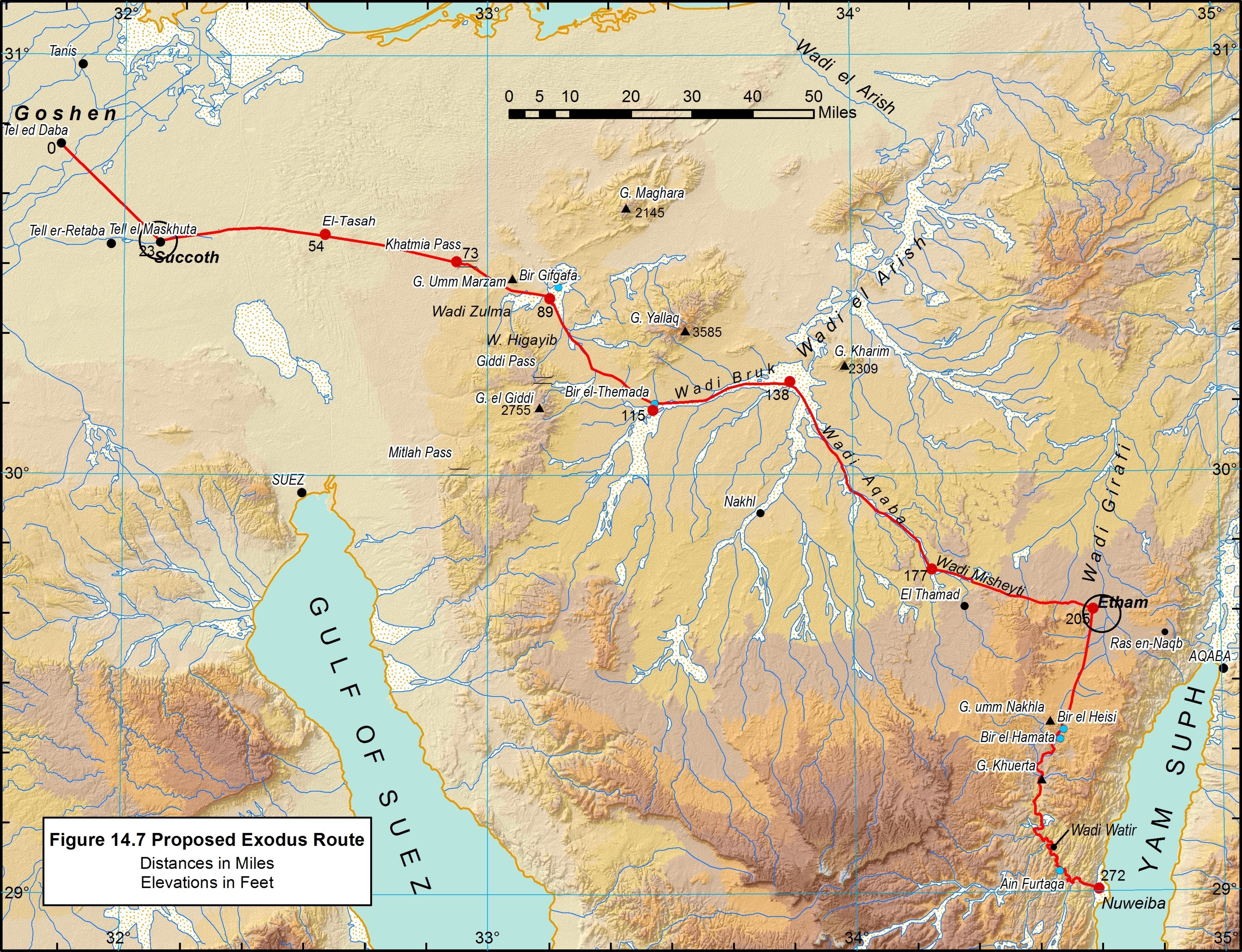
Map 1. Proposed Exodus Route Across the Sinai Peninsula. Click to enlarge.
En route to Arabia, (Exod. 13:20; 14:2), Moses received a divine command in Etham to turn from the path that lead to the head of the gulf and, instead, enter the wilderness to encamp somewhere on its shore. The only accessible and sizeable beachhead lies near the midpoint of the gulf at Nuweiba ( Map 1 ). Suitable seafloor topography also extends toward Arabia from that point, albeit in very deep water.
What was the likely Exodus route between Rameses and Nuweiba ?
Some investigators surmise that the Hebrews followed the Darb el Hajj (Arabic: “way of the pilgrimage”), a road developed for the Muslim Hajj after the 7 th -century emergence of Islam (see Map 2 ). The first peninsula Hajj road was constructed ca AD 875 by the Egyptian governor under the Fatimid Caliph. Much of the route lacks archaeological evidence of more ancient use. Darb el Hajj was a general term for various pilgrim routes leading to Mecca and the Sinai Peninsula route was called Tariq al-Hajj al-Masri , meaning “the opening stage of the Hajj.” Several variations of this road developed, but the main route was always outfitted with stations provisioned in advance with water and supplies. Although this route linked the heads of the gulfs (Suez and Aqaba), it would have been a problematic path in the Exodus because it notoriously lacked water and fodder.
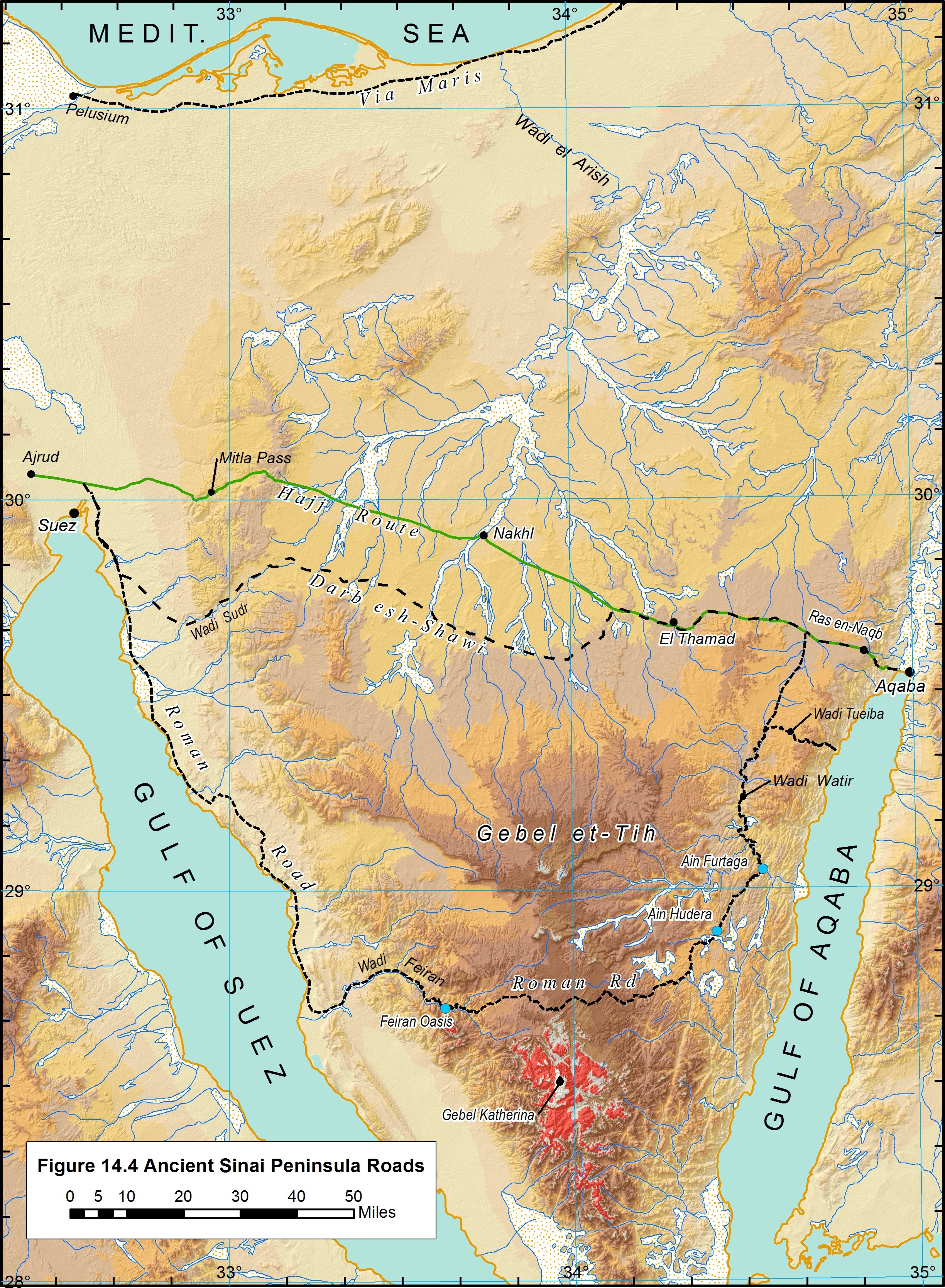
Map 2. Ancient Roads in the Sinai Peninsula . Click to enlarge.
There are three other historical routes across the Peninsula ( Map 2 ). The oldest, which followed the Mediterranean coast, was called “ways of Horus” by the Egyptians, and “Via Maris” (Latin: “way of the sea,” e.g., Latin Vulgate Matt. 43:15) by the Romans. The Bible called it the “way of the land of the Philistines,” but indicated that it was not used in the Exodus: “…when Pharaoh had let the people go, God led them not through the way of the land of the Philistines, although that was near…” (Exod. 3:17)
The oldest route connecting the heads of the gulfs was the Darb esh-Shawi (Arabic: “way of the heights”?). It also would have presented water and fodder limitations for the Hebrews.
Further south, the Roman Road, named for its depiction on the Roman-Byzantine (4 th -century AD) Peutinger Table , passed just north of the traditional Mount Sinai. Ancient Aramaic, Greek, Hebrew, and Arabic graffiti along this route indicate that it was used by Nabataeans prior to the Roman period and later by religious pilgrims. This route did provide some oasis stops, but it would have added much distance to the Hebrews’ trek across the Peninsula.
My research indicates that Moses did not follow any of the above routes. The Bible says that they took “the way of the wilderness of the Red Sea (Hebrew: yam suph )” (Exod. 13:18); yam suph referring to the Gulf of Aqaba.
The Hebrews left Egypt on the 15 th of Aviv , which fell close to the Spring Equinox (March 21) and coincided with the end of the Peninsula rainy season. Arabian explorer Alois Musil (1926) observed:
If the Israelites migrated from Egypt in the month of March and if there had been an abundance of rain on the peninsula of Sinai that year, they would have found rain pools of various sizes in all of the cavities and in all of the hollows of the various river beds, and they could have comfortably replenished their water bags and watered their flocks.
Considering these factors, the best conditions would have been offered by a route utilizing the extensive wadi (valley) network in the northern peninsula plateau. Not only do these wadis offer more passable terrain, they have a greater potential for providing water and vegetation. Following this line of thinking, explorer E. H. Palmer noted that:
In the larger wadies, draining as they do so extensive an area, a very considerable amount of moisture infiltrates through the soil, producing much more vegetation than in the plains. Sufficient pasturage for the camels is always to be had in these spots, and here and there a few patches of ground are even available for cultivation (Palmer 1872).
Map 1 lays out a feasible route through the network of low-lying wadis. The travel distance between Rameses and Nuweiba via this path is about 438 km (272 mi.). Given these circumstances, and the travel chronology in the book of Exodus, I estimate that the Hebrews crossed the Sinai Peninsula in as little as 18 days, an average of 15.1 miles per day.
Consult The Lost Sea of the Exodus for more details.
Share this:
The Nile Delta was a triangular area of marshland about 150 miles from north to south, from Memphis to the Mediterranean, and about 150 - 200 miles wide.
Upper Egypt was a bit further south from Lower Egypt, starting at Memphis (bottom of the Nile Delta Triangle) and extended for about 600 miles down the Nile River Valley to Elephantine (Aswan).
Genesis 47:6 - The land of Egypt [is] before thee; in the best of the land make thy father and brethren to dwell; in the land of Goshen let them dwell: and if thou knowest [any] men of activity among them, then make them rulers over my cattle.
Hosea 9:6 - For, lo, they are gone because of destruction: Egypt shall gather them up, Memphis shall bury them: the pleasant [places] for their silver, nettles shall possess them: thorns [shall be] in their tabernacles.
Exodus 14:1-2 - And the LORD spake unto Moses, saying, Speak unto the children of Israel, that they turn and encamp before Pihahiroth, between Migdol and the sea, over against Baalzephon: before it shall ye encamp by the sea.
Exodus 14:21-22 - And Moses stretched out his hand over the sea; and the LORD caused the sea to go back by a strong east wind all that night, and made the sea dry land, and the waters were divided. And the children of Israel went into the midst of the sea upon the dry ground: and the waters were a wall unto them on their right hand, and on their left.
Egypt in the Bible Encyclopedia - ISBE Egypt 1. The Basis of the Land: Though Egypt is one of the earliest countries in recorded history, and as regards its continuous civilization, yet it is a late country in its geological history and in its occupation by a settled population. The whole land up to Silsileh is a thick mass of Eocene limestone, with later marls over that in the lower districts. It has been elevated on the East, up to the mountains of igneous rocks many thousand feet high toward the Red Sea. It has been depressed on the West, down to the Fayum and the oases below sea-level. This strain resulted in a deep fault from North to South for some hundreds of miles up from the Mediterranean. This fault left its eastern side about 200 ft. above its western, and into it the drainage of the plateau poured, widening it out so as to form the Nile valley, as the permanent drain of Northeast Africa. The access of water to the rift seems to have caused the basalt outflows, which are seen as black columnar basalt South of the Fayum, and brown massive basalt at Khankah, North of Cairo. 2. The Nile Valley: The gouging out of the Nile valley by rainfall must have continued when the land was 300 ft. higher than at present, as is shown by the immense fails of strata into collapsed caverns which were far below the present Nile level. Then, after the excavations of the valley, it has been submerged to 500 ft. lower than at present, as is shown by the rolled gravel beds and deposits on the tops of the water-worn cliffs, and the filling up of the tributary valleys--as at Thebes--by deep deposits, through which the subsequent stream beds have been scoured out. The land still had the Nile source 30 ft. higher than it is now within the human period, as seen by the worked flints in high gravel beds above the Nile plain. The distribution of land and water was very different from that at present when the land was only 100 ft. lower than now. Such a change would make the valley an estuary up to South of the Fayum, would submerge much of the western desert, and would unite the Gulf of Suez and the Mediterranean. Such differences would entirely alter the conditions of animal life by sea and land. And as the human period began when the water was considerably higher, the conditions of climate and of life must have greatly changed in the earlier ages of man's occupation. Full Article
Egypt in Smith's Bible Dictionary
Egypt (land of the Copts), a country occupying the northeast angle of Africa. Its limits appear always to have been very nearly the same. It is bounded on the north by the Mediterranean Sea, on the east by Palestine, Arabia and the Red Sea, on the south by Nubia, and on the west by the Great Desert. It is divided into upper Egypt --the valley of the Nile --and lower Egypt, the plain of the Delta, from the Greek letter; it is formed by the branching mouths of the Nile, and the Mediterranean Sea. The portions made fertile by the Nile comprise about 9582 square geographical miles, of which only about 5600 is under cultivation. --Encyc. Brit. The Delta extends about 200 miles along the Mediterranean, and Egypt is 520 miles long from north to south from the sea to the First Cataract. NAMES. --The common name of Egypt in the Bible is "Mizraim." It is in the dual number, which indicates the two natural divisions of the country into an upper and a lower region. The Arabic name of Egypt --Mizr-- signifies "red mud." Egypt is also called in the Bible "the land of Ham," Ps 105:23,27 comp. Psal 78:51 --a name most probably referring to Ham the son of Noah --and "Rahab," the proud or insolent: these appear to be poetical appellations. The common ancient Egyptian name of the country is written in hieroglyphics Kem, which was perhaps pronounced Chem. This name signifies, in the ancient language and in Coptic, "black," on account of the blackness of its alluvial soil. We may reasonably conjecture that Kem is the Egyptian equivalent of Ham. GENERAL APPEARANCE, CLIMATE, ETC. --The general appearance of the country cannot have greatly changed since the days of Moses. The whole country is remarkable for its extreme fertility, which especially strikes the beholder when the rich green of the fields is contrasted with the utterly bare, yellow mountains or the sand-strewn rocky desert on either side. The climate is equable and healthy. Rain is not very unfrequent on the northern coast, but inland is very rare. Cultivation nowhere depends upon it. The inundation of the Nile fertilizes and sustains the country, and makes the river its chief blessing. The Nile was on this account anciently worshipped. The rise begins in Egypt about the summer solstice, and the inundation commences about two months later. The greatest height is attained about or somewhat after the autumnal equinox. The inundation lasts about three months. The atmosphere, except on the seacoast, is remarkably dry and clear, which accounts for the so perfect preservation of the monuments, with their pictures and inscriptions. The heat is extreme during a large part of the year. The winters are mild, --from 50 Full Article
The Exodus in Smith's Bible Dictionary
Exodus, The of the Israelites from Egypt. the common chronology places the date of this event at B.C. 1491, deriving it in this way: --In 1Ki 6:1 it is stated that the building of the temple, in the forth year of Solomon, was in the 480th year after the exodus. The fourth year of Solomon was bout B.C. 1012. Add the 480 years (leaving off one years because neither the fourth nor the 480th was a full year), and we have B.C. 1491 as the date of the exodus. This is probably very nearly correct; but many Egyptologists place it at 215 years later, --about B.C. 1300. Which date is right depends chiefly on the interpretation of the Scripture period of 430 years, as denoting the duration of the bondage of the Israelites. The period of bondage given in Ge 15:13,14; Ex 12:40,41 and Gala 3:17 as 430 years has been interpreted to cover different periods. The common chronology makes it extend from the call of Abraham to the exodus, one-half of it, or 215 years, being spend in Egypt. Others make it to cover only the period of bondage spend in Egypt. St. Paul says in Ga 3:17 that from the covenant with (or call of) Abraham the giving of the law (less than a year after the exodus) was 430 years. But in Ge 15:13,14 it is said that they should be strangers in a strange land,a nd be afflicted 400 years, and nearly the same is said in Ex 12:40 But, in very truth, the children of Israel were strangers in a strange land from the time that Abraham left his home for the promised land, and during that whole period of 430 years to the exodus they were nowhere rulers in the land. So in Ex 12:40 it is said that the sojourning of the children of Israel who dwelt in Egypt was 430 years. But it does not say that the sojourning was all in Egypt, but this people who lived in Egypt had been sojourners for 430 years. (a) This is the simplest way of making the various statements harmonize. (b) The chief difficulty is the great increase of the children of Israel from 70 to 2,000,000 in so short a period as 215 years, while it is very easy in 430 years. But under the circumstances it is perfectly possible in the shorter period. See on ver. 7 (c) If we make the 430 years to include only the bondage in Egypt, we must place the whole chronology of Abraham and the immigration of Jacob into Egypt some 200 years earlier, or else the exodus 200 years later, or B.C. 1300. in either case special difficulty is brought into the reckoning. (d) Therefore, on the whole, it is well to retain the common chronology, though the later dates may yet prove to be correct. The history of the exodus itself commences with the close of that of the ten plagues. [PLAGUES, THE TEN] In the night in which, at midnight, the firstborn were slain, Ex 12:29 Pharaoh urged the departure of the Israelites. vs. Ex 12:31,32 They at once set forth from Rameses, vs. Ex 12:37,39 apparently during the night v. Ex 12:42 but towards morning on the 15th day of the first month. Nu 33:3 They made three journeys, and encamped by the Red Sea. Here Pharaoh overtook them, and the great miracle occurred by which they were saved, while the pursuer and his army were destroyed. [RED SEA, PASSAGE OF] Full Article
The Red Sea in Smith's Bible Dictionary
The Passage of the Red Sea It is necessary to endeavor to ascertain the route of the Israelites before we can attempt to discover where they crossed the sea. The point from which they started was Rameses, a place certain in the land of Goshen, which we identified with the Wadi-t-Tumeylat. They encamped at Succoth. At the end of the second day's journey the camping place was at Etham, "in the edge of the wilderness." Ex 13:20; Nu 33:6 Here the Wadi-t-Tumeylat was probably left, as it is cultivable and terminates in the desert. At the end of the third day's march for each camping place seems to mark the close of a day's journey the Israelites encamped by the sea, place of this last encampment and that of the passage would be not very far from the Persepolitan monument at Pihahiroth. It appears that Migdol was behind Pi-hahiroth and on the other hand Baalzephon and the sea. From Pi-hahiroth the Israelites crossed the sea. This was not far from halfway between the Bitter Lakes and the Gulf of Suez, where now it is dry land. The Muslims suppose Memphis to have been the city at which the Pharaoh of the exodus resided before that event occurred. From opposite Memphis a broad valley leads to the Red Sea. It is in part called the Wadi-t-Teeh, or "Valley of the Wandering." From it the traveller reaches the sea beneath the lofty Gebel-et-Takah, which rises in the north and shuts off all escape in that direction excepting by a narrow way along the seashore, which Pharaoh might have occupied. The sea here is broad and deep, as the narrative is generally held to imply. All the local features seem suited for a great event. The only points bearing on geography in the account of this event are that the sea was divided by an east wind. Whence we may reasonably infer that it was crossed from west to east, and that the whole Egyptian army perished, which shows that it must have been some miles broad. Full Article
The Bible Mentions "Egypt" Many Times
The Israelites’ Wandering: A Map of Their 40-Year Journey in the Wilderness

The story of the Israelites' wandering in the wilderness is one of the most well-known and powerful stories in the Bible. According to the Book of Exodus , after being led out of Egypt by Moses, the Israelites spent 40 years wandering in the wilderness before finally reaching the Promised Land. But have you ever wondered exactly where they traveled during this time?
By using maps, we can trace their journey through the wilderness and gain a deeper understanding of this powerful story.
The journey of the Israelites began at the Red Sea, where they crossed on dry ground after God parted the waters. From there, they traveled south to the area of Marah, where they found bitter water that was made sweet by a miracle from God. They then continued eastward to the desert of Sin, where they were provided with manna from heaven and quail to eat.
The Israelites then traveled to Mount Sinai , where they received the Ten Commandments and other laws from God. After spending several months at Sinai, they continued their journey northward towards the Promised Land, but their progress was slowed by their disobedience and lack of faith in God.
The Israelites continued to wander in the wilderness for another 38 years, traveling back and forth across the desert and encountering many challenges and trials along the way. They fought battles against other nations, complained about their lack of food and water, and even rebelled against Moses and God on several occasions.
Finally, after 40 years of wandering, the Israelites reached the Promised Land , which was located on the eastern shores of the Jordan River . By using maps, we can see the locations of the places where they camped, the routes they took, and the challenges they faced during their journey.
A map of the Israelites' 40-year journey in the wilderness can help us to better understand this powerful story and the faith and perseverance of the Israelites. By tracing their journey, we can see the locations of the places where they camped and the routes they took, and gain a deeper appreciation for their struggles and ultimate triumph. So why not take a journey through the wilderness with the Israelites and discover the power of their story?
Related Posts

How to Easily Download Videos from Reddit: A Step-by-Step Guide
Reddit is a treasure trove of content, starting from pleasing videos and insightful discussions to hilarious GIFs and beautiful photos.... Read More

Church Platform Chairs: A Comprehensive Guide
Church platform chairs play a critical role in the design and functionality of worship spaces. These chairs are not just... Read More

Top 10 Essential Tips for a Successful Home Remodeling Project
Embarking on a home remodeling project can be both exciting and daunting. Whether you're updating a single room or undertaking... Read More

Brow Lamination Toronto & Beauty Through the Ages: A Fascinating Journey
The Art of Beauty: From Ancient Egyptians to brow lamination Toronto Have you ever wondered how our ideas approximately beauty have... Read More
2. Israel’s Exodus from Egypt and Entry into Canaan
Possible route of the Exodus
Jordan River
Salt Sea (Dead Sea)
Great Sea (Mediterranean Sea)
Philistines
River of Egypt
Wilderness of Zin
Rameses (Tanis)
Wilderness of Shur
Kadesh-barnea
Wilderness of Paran
Arabah (Rift Valley)
Eastern Wilderness
On (Heliopolis)
Pi-hahiroth?
Wilderness of Etham
Sinai Peninsula
Ezion-geber
Noph (Memphis)
Gulf of Suez
Wilderness of Sin
Sinai Wilderness
Wilderness Camps
Gulf of Aqaba
Mt. Sinai? (Horeb)
0 40 80 120
Rameses Israel was thrust out of Egypt ( Ex. 12 ; Num. 33:5 ).
Succoth After the Hebrews left this first campsite, the Lord attended them in a cloud by day and in a pillar of fire by night ( Ex. 13:20–22 ).
Pi-hahiroth Israel passed through the Red Sea ( Ex. 14 ; Num. 33:8 ).
Marah The Lord healed the waters of Marah ( Ex. 15:23–26 ).
Elim Israel camped by 12 springs ( Ex. 15:27 ).
Wilderness of Sin The Lord sent manna and quail to feed Israel ( Ex. 16 ).
Rephidim Israel fought with Amalek ( Ex. 17:8–16 ).
Mount Sinai (Mount Horeb or Jebel Musa) The Lord revealed the Ten Commandments ( Ex. 19–20 ).
Sinai Wilderness Israel constructed the tabernacle ( Ex. 25–30 ).
Wilderness Camps Seventy elders were called to help Moses govern the people ( Num. 11:16–17 ).
Ezion-geber Israel passed through the lands of Esau and Ammon in peace ( Deut. 2 ).
Kadesh-barnea Moses sent spies into the promised land; Israel rebelled and failed to enter the land; Kadesh served as the main camp of Israel for many years ( Num. 13:1–3, 17–33 ; 14 ; 32:8 ; Deut. 2:14 ).
Eastern Wilderness Israel avoided conflict with Edom and Moab ( Num. 20:14–21 ; 22–24 ).
Arnon River Israel destroyed the Amorites who fought against them ( Deut. 2:24–37 ).
Mount Nebo Moses viewed the promised land ( Deut. 34:1–4 ). Moses delivered his last three sermons ( Deut. 1–32 ).
Plains of Moab The Lord told Israel to divide the land and dispossess the inhabitants ( Num. 33:50–56 ).
Jordan River Israel crossed the Jordan River on dry ground. Near Gilgal, stones from the bottom of the Jordan River were placed as a monument of Jordan’s waters being divided ( Josh. 3:1–5:1 ).
Jericho The children of Israel captured and destroyed the city ( Josh. 6 ).

Biblical Historical Context
A Christian layman’s perspective on the intersection between archaeology, historical criticism, text, and faith.
- Custom Social Profile Link
The Exodus Itineraries
9 minute read
Reading itineraries has a similar effect on the mind as reading genealogies . But, it’s worth ploughing through them for the same reason we should suffer the name lists – there’s often more in there than meets the eye. The Exodus itineraries are no exception.
There are three main sources in the Hebrew Bible for the Israelites’ itinerary through the wilderness between Egypt and Canaan:
- Numbers 33 – It sticks fairly closely to an itinerary format, i.e. “They set out from X and camped at Y”, making it quite easy to draw up a list of all the places the Israelites passed through.
- The narratives found in Exodus and Numbers – This itinerary takes a little more work to extract, but it’s not too much hassle. It begins in Rameses (Exodus 12:37) and ends on the plain of Moab (Numbers 22:1).
- Moses’ speech in Deuteronomy 1-3 – Here the Israelites’ journey begins at Mt Sinai (Deuteronomy 1:19) and ends in the valley opposite Beth-peor (Deuteronomy 3:29).

Overview of the itineraries
Here’s a short summary of each itinerary. Bear in mind that most of the places mentioned in all three sources have not been firmly identified, 1 neither does their location really matter for what we’re dealing with in this post. So we’re sticking with the traditional locations for now.
The Israelites leave Rameses (Nu 33:3), cross the Red Sea (Nu 33:8), wander through the wilderness of Sin (Nu 33:11), finally arriving at Sinai (Nu 33:15).

After leaving Sinai they head through the Sinai desert passing through Hazeroth (Nu 33:17) up to Ezion Geber near modern Eilat (Nu 33:35) on their way to Kadesh in the wilderness of Zin (Nu 33:36).

From Kadesh they head east (Nu 33:40), through Oboth (Nu 33:43) up onto the Transjordanian plateau (Nu 33:44).
They then head north up the King’s Highway straight through the territory of Moab through Dibon (Nu 33:45).

From there they continue up through Moab to Nebo, then west down into the Plain of Moab opposite Jericho (Nu 33:48).
Here’s what it looks like on a map:

Exodus & Numbers narratives
From Rameses (Ex 12:37) the Israelites travel to the point opposite Migdol (Ex 14:2), and cross the Red Sea (Ex 14:22). They then head via the wilderness of Sin (Ex 16:1) and Rephidim (Ex 17:1) to Sinai (Ex 19:1-3).

After receiving the law they head north via Hazeroth (Nu 11:35) to Kadesh (Nu 13:26) from where the 12 spies are sent out.
As a result of the faithless report brought back by the spies the Israelites are condemned to wander in the wilderness for forty years (Nu 14:33-35) in the region of the Aravah (Nu 14:25).
After many years they come back to Kadesh (Nu 20:1) where Miriam dies. Next they go to Mt Hor, where Aaron dies (Nu 20:22-29). From there they head east to the Aravah – the Jordan Valley south of the Dead Sea – and travel on the Way to the Red Sea (Nu 21:4). Going through Oboth (Nu 21:10) they climb onto the Transjordanian plateau (Nu 21:11)

The Israelites then head north to the river Zered (Nu 21:12) and continue on to the river Arnon (Nu 21:13). Still moving north they travel through Moab until they get to the top of Pisgah (Nu 21:20). After conquering the Transjordan (Nu 21:21–35) the Israelites head west down onto the Plain of Moab opposite Jericho (Nu 22:1).

And now in map form:

Moses’ speech in Deuteronomy
Slightly unconventionally, this itinerary begins with the Israelites at Mt Sinai. From there they speed through to Kadesh (Dt 1:19) from where the spies are sent out (1:22–39).
The Israelites are then told to head back into the wilderness toward the Red Sea (Dt 2:1) and “skirt Mount Seir for many days” (Dt 2:1) – Mount Seir is the name for the range of hills to the east of the Aravah north of Eilat. 2

They wander in this area (described as being the area of the Aravah, Eilat, and Ezion Geber) for a long time (Dt 2:3) and then head into Mt Seir (Dt 2:8) – following the modern route from Aqaba to Wadi Rum in the direction of Moab.

Along the way the Israelites cross the River Zered (Dt 2:13) where the last of the Israelites who left Egypt die off (Dt 2:14-15).
Having been told not to engage the Moabites in warfare (Dt 2:9) who were located at this time between the Zered and the Arnon they head north peacefully to the River Arnon (Dt 2:24).

Once across the Arnon the Israelites take all the cities from there (Aroer being nestled on the northern edge of the Arnon), up to Gilead (Dt 2:36) in a thin strip to the east of the Kingdom of the Ammonites (Dt 2:37).
After fighting Og king of Bashan (Dt 3:1-7) and dividing up the territory they’d captured (Dt 3:8-17) we find the Israelites camped in the valley opposite Beth-peor (Dt 3:29).
And, on a map:

If it’s not clear yet, we’re dealing with quite different itineraries.
Combining the itineraries
If we place all three itineraries on the same map we get the following:

See? Itineraries are interesting.
Differences
Let’s highlight a couple of differences between the itineraries:
- The Exodus and Numbers narratives place the decades of wilderness wandering between the two visits to Kadesh. The first time they visit the spies are sent out; the second time they visit Miriam dies. Numbers 33 on the other hand has only one visit to Kadesh. Moses’ speech in Deuteronomy also has only one visit. The Deuteronomy itinerary does mention the wilderness wandering, but it is explicit in that when they’re finished wandering the Israelites head into Mt Seir; not Kadesh which would be in almost the opposite direction.
- In Numbers 33 and the Exodus and Numbers itineraries the journey from Kadesh (the only time in Numbers 33 and second visit in the Exodus and Numbers itinerary) to the Transjordanian plateau goes due east through Zin, across the Aravah and through Oboth before walking through the ravines up onto the Transjordanian plateau. In Deuteronomy on the other hand the Israelites head from Kadesh (their only visit) south-east towards Eilat, and from there they head through the Wadi Rum area and then head north.
These differences between the itineraries cannot be reconciled. You cannot visit Kadesh both only once and twice. You cannot travel from Kadesh both due east across the Aravah into Transjordan and south to Eilat and up into the Edomite hills in the direction of Wadi Rum.
A known problem?
We are not the first to stumble across these differences, so let’s see what others have written on the matter.
First up is Aharoni, a towering figure in the archaeology of Israel. Discussing the Kadesh-to-Plain-of-Moab itinerary of Deuteronomy vs. that found in the Numbers narrative he writes:
It would seem, therefore, that there are preserved here memories of two different journeys, the first in the fourteenth century to the plains of Moab before the various kingdoms in this area became organised, and the second in the thirteenth century which led around Edom and Moab along the fringe of the desert and which ended in the conquest of Heshbon. These different routes constitute one of the conclusive evidences that the Israelite conquest was not carried out in one campaign or at one time but rather continued in several waves which were blended together in the tradition to a single campaign of conquest. 3
Brown in his Expositional Bible Commentary provides no explanation for the differences, but he does note that they exist:
Moses recounts the way in which God brought the people to the border of Canaan by a different route and to a different place from the first occasion. 4
And before launching into an excellent treatment of the problem Tigay in the JPS Torah Commentary on Deuteronomy wryly notes:
There are several apparent discrepancies between these descriptions of the Israelites’ route. 5
So, we’re dealing with a known problem. The itineraries are different.
Is there an explanation for the differences?
In Aharoni’s writings we see one attempt to explain the problem: the different itineraries are attributed to different Exoduses. One itinerary was followed by one group at one point in time, another itinerary was followed by a different group at a different point in time.
Others have attempted to “fix” the itineraries, e.g. finding a second Kadesh in the Numbers 33 itinerary – they claim that Nu 33:16’s Kibroth Hattaavah is another name for Kadesh. 6 This however doesn’t work – Kibroth Hattaavah is somewhere that the Israelites visit on their way to Kadesh (cf. Nu 11:34 & 13:26).
Others claim that the Exodus and Numbers narratives along with the Numbers 33 itineraries simply miss out the portion of the journey that took them down to Eilat and up into the mountains of southern Jordan, thus reconciling the Deuteronomy itinerary with the others. 7
Finally, in the view of those following critical approaches, the inconsistencies between the itineraries are the result of a late editor weaving together ancient sacred documents, not feeling like they could change or cut out sections which made the final product contradictory. 8
Conclusions
What can be learned from this?
Robustly made and pious sounding claims of internal consistency within the biblical text are nothing but bluster and wishful thinking. Any such claims don’t match the evidence – discrepancies exist, as the various Exodus itineraries demonstrate.
If discrepancies in the Bible make us uncomfortable that only tells us that our understanding of the nature of the text needs adjusting.
Finally, instead of making untrue – and therefore disrespectful – claims about the nature of the text, we should base our understanding of it on what we find in it, and we should do so in a humble and inquiring manner.
So, let’s work with what the text says, not try to pretend it says something else.
Further reading
- An excellent introduction to the discrepancies between the various Exodus itineraries can be found in “Excursus 2: The Chronology and Route of the Wanderings from Kadesh to Transjordan” in Jeffrey H. Tigay, Deuteronomy (The JPS Torah Commentary; Philadelphia: Jewish Publication Society, 1996), 425–429.
Featured image
A photo I took on the way down from the top of Jebel Musa, the traditional site of Mt Sinai.
Baruch A. Levine, Numbers 21–36: A New Translation with Introduction and Commentary (vol. 4A; Anchor Yale Bible; New Haven; London: Yale University Press, 2008), 511. ↩
Ernst Axel Knauf, “Seir (Place),” ed. David Noel Freedman, The Anchor Yale Bible Dictionary (New York: Doubleday, 1992), 1072–1073. ↩
Yohanan Aharoni, The Land of the Bible (Philadelphia, Pensylvania: Westminster Press, 1979), 205-206. ↩
Paul E. Brown, Deuteronomy: An Expositional Commentary (Exploring the Bible Commentary; Leominster, UK: Day One Publications, 2008), 22. ↩
Jeffrey H. Tigay, Deuteronomy (The JPS Torah Commentary; Philadelphia: Jewish Publication Society, 1996), 426. ↩
Ibid, 428. ↩
Ibid. ↩
You May Also Enjoy

A file for the mattocks!?
How archaeology can inform Bible translation.

The Black Obelisk’s journey from Nimrud to London
42 minute read
The pretty wild ride that the Black Obelisk took from Nimrud, where it was found, to the British Museum, where it’s displayed to this day.

The Merneptah Stele: Beyond Apologetics
34 minute read
The Merneptah Stele’s discovery, transcription, and what it shows us about annihilation in the biblical text.

The Tel Dan Stele: Beyond Apologetics
53 minute read
The Tel Dan Stele’s discovery, the debate it caused, and how it shows that scripture sometimes doesn’t work the way we think it does.
- Log In Sign Up
- Read the Bible
- Bible Versions
- Verse of the Day
- Reading Plans
- Verses by Topic
- Books of the Bible
- Bible Images
- Commentaries
- Concordances
- Dictionaries
- Encyclopedias
- Bible Atlas & Maps
- Devotionals
- Today's Devotionals
- Light of the World
- All Devotionals
- Inspirational Quotes
- Picture Quotes
- Inspirational
- Bible Study
- What The Bible Says
- Bible Q&As
- Daily Bread
- Bible by Genre
- Bible Stories
- Random Bible Verse
The Exodus Route
Be the first to react on this!
Get Bible verse every day in your inbox
Read on Mobile

Group of Brands

- Statement of Faith
- Privacy Policy
- Terms and Conditions
- Permissions Policy
- BP ScriptureTagger
- VotD RSS Feeds
- Article RSS Feeds
6200 2nd St NW Washington, DC 20011
This map is part of a series of 12 animated maps showing .
▶ view series: the bible and history, the routes of the exodus.
This map is part of a series of 12 animated maps showing the history of The Bible and History.
Towards the end of the Book of Genesis, Abraham’s grandson Jacob travelled to Egypt with all his tribe in order to escape the famine that was devastating Canaan.
In the Book of Exodus, it is said that, after several generations, Jacob’s descendants were still living in Egypt and had been reduced to slavery.
God then ordered Moses and his brother Aaron to take the Hebrews out of Egypt and lead them into the Land of Canaan. Because the Pharaoh [ identified by some Biblical scholars as Ramesses II ] refused to release them , God inflicted several disasters on the Egyptians, known as the ‘ten plagues of Egypt’.
The Hebrews managed to leave but were chased by the Egyptian Army. This led to the famous episode when the sea opened up before the People of Israel and let them cross over. It then closed again on the Egyptians. This sea is usually believed to be the Red Sea.
The most direct route from Northern Egypt to Canaan lies along the Mediterranean coast, a long way from the Red Sea. But Canaan was at that time ruled by Egypt and this route would have been protected by garrisons established in fortresses.
Drawing on information in the Book of Exodus and the Book of Numbers, Biblical scholars have established two possible routes for the Hebrews.
The first would have taken them from the south of the Sinai Peninsula to the mountain known in Arabic as Jabal Musa (‘Mount Moses’), where the Divine Law is said to have been revealed to Moses.
After the revelation of God’s Law, the Hebrews continued their journey and reached the gates of the Promised Land, south of the Negev Desert.
According to the second itinerary, they would have taken a more northernly route which ran parallel to the coast as far as the mountain called Jabal Halal.
The Book of Numbers [chaps. 13–14] tells us that, despite the miracles performed by God, the Hebrews later revolted against him and Moses and that, being very afraid, they refused to go further into Canaan. For this reason, they were condemned to wander in the desert for 40 years.
Subsequently they travelled to the Gulf of Aqaba and then marched north, either via the so-called Valley of Arabah, linking the Gulf of Aqaba to the Dead Sea, or by a more mountainous route to the east close to Arabia.
They finally reached the shores of the Dead Sea and the eastern banks of the River Jordan which they had to cross in order to enter the Promised Land.
The story of the Exodus is the origin of the Jewish Feast of Passover and consequently of the Christian Easter. However, according to most archaeologists and Biblical scholars, the historical reality of this event is open to question.
Some Egyptian documents mention several occasional escapes by Levantine slaves. It is possible that the Exodus story emanates from the memory of a small group that might have experienced these kinds of events. This might have been transformed over time into a foundation story for the Hebrew people.
You are using an outdated browser. Upgrade your browser today or install Google Chrome Frame to better experience this site.
- Bible Studies
- New/Special
- Encouragement
- Christian Symbols
- Scholarly Articles
- Way of the Cross
- Thanksgiving
- St. Patrick's Day
- New Year's Day
- Steps to Peace with God
- Articles/Stories
Beginning the Journey (for new Christians) . en Español
Old Testament Abraham Jacob Moses Joshua Gideon David, Life of Elijah Psalms Solomon Songs of Ascent (Ps 120-135) Isaiah Advent/Messianic Scriptures Daniel Rebuild & Renew: Post-Exilic Books
Gospels Christmas Incarnation (Mt, Lk) Sermon on the Mount (Mt 5-7) Mark Luke's Gospel John's Gospel 7 Last Words of Christ Parables Jesus and the Kingdom Resurrection
Acts The Early Church (Acts 1-12) Apostle Paul (Acts 12-28)
Paul's Epistles Christ Powered Life (Rom 5-8) 1 Corinthians 2 Corinthians Galatians Ephesians Vision for Church (Eph) Philippians Colossians, Philemon 1 & 2 Thessalonians 1 & 2 Timothy, Titus
General Epistles Hebrews James 1 Peter 2 Peter, Jude 1, 2, and 3 John
Revelation Revelation Conquering Lamb of Revelation
Topical Glorious Kingdom, The Grace Great Prayers Holy Spirit, Disciple's Guide Humility Lamb of God Listening for God's Voice Lord's Supper Names of God Names of Jesus Christian Art
Appendix 2. The Route of the Exodus.
The route of the Exodus has been hotly debated. Since there are no archaeological artifacts from the Exodus itself and place names seldom match places identifiable today, we are left to sort out the probable route based on clues from the biblical accounts and the land itself. Three main routes of the Exodus to Mt. Sinai have been proposed.
1. Northern Sinai Route
The Northern Route sees the "Reed Sea" as Lake Serbonis, then along the Mediterranean coast of Sinai. It finds Mount Sinai in the northern part of the Sinai Peninsula. However, this route was heavily fortified by the Egyptians, since it constituted the route enemies would take to attack Egypt. This route is explicitly excluded by the text:
"When Pharaoh let the people go, God did not lead them on the road through the Philistine country, though that was shorter . For God said, 'If they face war, they might change their minds and return to Egypt.' So God led the people around by the desert road toward the Red Sea." (Exodus 13:17-18)
Moreover, the present Lake Serbonis probably didn't yet exist at the time of Moses.
2. Central Sinai Route
A route directly east of the end of Wadi Tumilat across the center of the Sinai Peninsula doesn't have enough wells to support this body of people and animals.
I've recently seen a variation on this -- not held by any reputable scholar -- that claims the "real" Red Sea ("Reed Sea") is the Gulf of Aqaba, the "real" Mt. Sinai is Jebel el Lawz in Arabia. The theory holds that Pharaoh's chariots chased the Israelites across the center of the Sinai Peninsula, then down the steep canyon of Wadi Watir, across Nuweiba beach, and a slightly submerged land bridge into Arabia. 1 The problem with this view is that the Scripture shows the confrontation between Pharaoh and Moses at the Red Sea before the trek across the Sinai Peninsula, not after it. It just doesn't fit the facts of Scripture.
3. Southern Sinai Route (Traditional)
Below is a map that shows the traditional route that makes the most sense to me.
The traditional route crosses the "Reed Sea" at perhaps Lake Timsah or the Bitter Lakes, then down Sinai's west coastlands, then east through the mountains and wadis to a southern Mount Sinai, perhaps Jebel Musa, then back up northeastward by Sinai's east coast and desert to Kadesh-barnea. This route has the advantage that it:
- Steers clear of nearly all Egyptian presence.
- The Shur desert was also called the desert of Etham (Numbers 33:8), in the latitude of the east end of Wadi Tumilat. So, moving through that desert for three days (if the middle way of Seir is excluded) has to be southward along the west coast of Sinai. 2
- The west coast of Sinai has a number of known watering places.
Of course, no one knows the route for sure. Very few of the stages of the journey outlined in Numbers 33 have been identified with any certainty, with the exception of Ezion Geber, Kadesh Barnea, and the plains of Moab.
Nevertheless, let's discuss some of the locations that we're more sure about -- plus a couple of others.
Ramses, Pithom, and Succoth (Exodus 12:37)
The locations of both Ramses and Succoth have been fairly well established. Scholars identify Rameses ("house of Rameses") as Qantir or Tell el-Dab`a, the ancient Avaris/Pi-Ramesse. 3 It was originally built on the eastern bank of the Pelusiac, the easternmost of the Nile's five ancient branches. Later, prior to 1069 BC, the course this branch of the Nile migrated away from the city, and the site was abandoned.
Succoth 4 (the modern Tell el-Maskhuta) is found in the Wadi Tumilat of the southeast delta. 5 The name Succoth in Hebrew means "temporary shelters, tents, booths," which corresponds to the Egyptian name Tjeku.
Kitchen makes a strong case to identify Pithom ("house of the god Atum") as Tell er-Retabe along the Wadi Tumilat, a few miles due west of Succoth. 6
Location of the Red Sea or yām sûp
We just don't know the exact location of the body of water identified in the text as the "Red Sea." The Hebrew is yām sûp , a term used in the Old Testament to identify a number of different bodies of water. Yām is used in the Old Testament over 300 times to refer to "sea" and about 70 times for "west" or "westward." 7 The word sûp means "reed, waterplant," a general term for marsh plants. 8 What we know as the Red Sea today lies to the south, with two northern branches, the Gulf of Aqabah to the east of the Sinai Peninsula and the Gulf of Suez to the west of the Sinai Peninsula.
According to 1 Kings 9:26 and other passages, 9 the term yām sûp is used to describe Gulf of Aqabah (Elat), the body of water east of the Sinai Peninsula. Of course, in many many passages, yām sûp is the sea of the Exodus. 10
We conclude, then, that the "Red Sea" ( yām sûp ) refers to some body of water east of the Nile delta. Scholars have found evidence of ancient canals in this area. Here are the primary possibilities of bodies of water we see today along the line of the present-day 101-mile Suez Canal, which opened in 1869. North to south, these are:
- Lake Ballah
- Lake Timsah
- Great Bitter Lake
- Little Bitter Lake
Water tables, no doubt, are different now than they were 3,000 years ago, so we can't judge just by what we see today. Some believe that the Gulf of Suez gradually receded over the centuries, its coastline slowly moving farther and farther southward away from Lake Timsah and the Greater Bitter Lake to its present coastline today. 11 "It is plausible, even if they were marshy areas, that the Israelites crossed while the area was flooded, which occurred periodically." 12 The exact spot of the crossing is impossible to determine with certainty, but it probably occurred either at Lake Timsah or at the Great Bitter Lake.
The Sinai Coast
If, indeed, the Israelites took the traditional southern route, it would have been a difficult trip. Beno Rothenberg notes:
"Sinai's broad southern littoral [area near the shoreline] is for the most part a sandy waste. In the wadi-estuaries and in a few depressions between the sea and the mountains of Sinai the yellow sand is relieved by white patches of chalk and limestone, sometimes mingled with loess. In such parts there is water and vegetation: tamarisks, date-palms, and acacias. But the parched soil shrivels and crumples up in the fierce desert heat." 13
Marah (Exodus 15:23)
Marah has been traditionally identified with Ain Hawara, but there can be no certainty. Beno Rothenberg observed in 1957 that Ain Hawara is "a spring now completely buried in sand. Only a cluster of date-palms and a damp spot nearby are there to tell of its existence." 14
Elim (Exodus 15:27)
It has always been tempting for scholars to try to locate the oasis of Elim.
"Then they came to Elim, where there were twelve springs and seventy palm trees, and they camped there near the water." (Exodus 15:27)
Elim ( ʾ�lim ) is the plural of ʾayil , "terebinth, great tree," so Elim means "(place of) great trees." 15 Some scholars identify Elim with the modern day Wadi Gharandel, located on the west coast of the Sinai Peninsula and the site of numerous palm trees, 16 but it is by no means proven.
Mount Sinai
The exact location of Mount Sinai (sometimes referred to as Mount Horeb) is unknown. There are three theories as to its general location:
- Northern Sinai . Candidates suggested are Jebel Helal, Jebel Kharif, Jebel Sin Bisher, Jebel Yeleq, Jebel Magharah, Jebel Karkom, or Kadesh-barnea itself.
- Arabia . Mountains suggested are present-day Petra, el-Khrob, or Hala el-Bedr. This has a long tradition, but is unlikely. 17
- Southern Sinai . The traditional southern route of the Exodus suggests four possible peaks, which I think are most likely, all clustered together: Jebel Musa ("Mountain of Moses") is 7,498 feet in elevation, Jebel Katarina is 8,551 feet, and Ras Safsafa is 7,113 feet. Jebel Serbal (6,739 feet) is west a few miles, near the Monastery of St. Catherine. Which of these peaks is the real Mount Sinai, God only knows, but each has its proponents. 19
The location of Rephidim is unknown. However, many have placed it near the Oasis of Feiran. Yohanan Aharoni comments:
"Wadi Feiran is one of the largest and most famous wadis in Sinai. It is 81 miles long and begins in the region of Jebel Musa, where it is called Wadi el Sheikh. Feiran boasts the chief oasis in Sinai, one of the wonders of the Peninsula. In the heart of the bleak and forbidding granite mountains a green parkland suddenly comes into view: over 6 miles of date-palm groves, tamarisks, reeds, rushes, and other vegetation, with a small sparkling stream to delight the eye, artesian wells, and even a petrol engine to draw up the water. The inhabitants are Bedouin." 20
Kadesh-Barnea
Kadesh is almost certainly to be identified with Ain el-Qudeirat in the Wadi el-Ain of the northern Sinai. "The vegetation near Ain el-Qudeirat and its ample supply of water suit very well the topographical requirements of the wilderness narratives." 21 Ain el-Qudeirat is the richest spring in the Sinai, having a flow of about 40 cubic meters per hour. 22
The actual location of Mount Hor is unknown, but was considered in Edomite territory. Josephus identified Mount Edom as Jebel Nebi Harim near Petra. But a more likely location might be Jebel Madura, about 15 miles northeast of Kadesh at the edge of Edom's territory. 23
Ezion-geber (Numbers 33:35; Deuteronomy 2:8)
Ezion-geber is almost surely located at Tell el-Kheleifeh at the north end of the Gulf of Aqaba.
Dizahab (Deuteronomy 1:1)
Dizahab must surely be related to the present town of Dahab, as both names are phonetic equivalents and both have to do with places of gold. 24
Jotbathah (Numbers 33:33)
Jotbathah is quite likely to be the oasis of Taba, located about seven miles south of Ezion-geber on the eastern side of the Sinai Peninsula. 25
Of course there are many speculations as to other identifications, but these are the most likely.
1 . This view is "explained" in a series of slides on the Grace upon Grace Ministries website.� http://graceupongraceministries.org/video-feed� It is explained by Russell and Colin Standish, Holy Relics or Revelation (Rapidan, VA: Hartland Publications).
2 . This analysis draws heavily on K.A. Kitchen, On the Reliability of the New Testament (Eerdmans, 2003), pp. 265-274. See also Peter Enns, "Exodus Route and Wilderness Itinerary," DOTP, pp. 272-280.
3 . P. Enns, "Exodus Route and Wilderness Itinerary," DOTP pp. 272-280, especially p. 273.
4 . Exodus 12:37; 13:20; Numbers 33:5-6
5 . W.L. Thompson, Jr., "Succoth," ISBE 4:648); Kitchen, Reliability , pp. 256-259.
6 . Kitchen, Reliability , pp. 256-259. J.H. Walton, "Exodus, Date of," DOTP, p. 262.
7 . Paul R. Gilchrist, yām , TWOT #871a.
8 . R.D. Patterson, sûp, TWOT #1479. Exodus 2:3, 5; Isaiah 19:6; Jonah 2:5.
9 . Also Exodus 23:31; Numbers 14:25; 21:4; Deuteronomy 1:40; 2:1; Judges 11:16; Jeremiah 49:21.
10 . Exodus 15:4, 22; Joshua 2:10; 4:23; Psalm 106:7, 9, 22.
11 . "Suez Canal," Wikipedia, 12 Dec 2010, citing Édouard Naville, "Map of the Wadi Tumilat" (plate image), in The Store-City of Pithom and the Route of the Exodus (London: Trubner and Company, 1885); S Rappoport, History of Egypt (London, Grolier Society, undated, early 20th century), Volume 12, Part B, Chapter V: "The Waterways of Egypt," pages 248-257.
12 . P. Enns, "Exodus Route and Wilderness Journey," DOTP, p. 276.
13 . Ben Rothenberg, God's Wilderness , p. 93, plate 30.
14 . Ben Rothenberg, God's Wilderness , p. 94, plate 33.
15 . ʾAyil , BDB 18.
16 . Kitchen, Reliability , p. 269, who sees it "possible, but not proven."
17 . Arguments pro and con are presented in Beitzel, Atlas , pp. 90-91.
18 . Map relies on Beitzel, Atlas , pp. 86-87, map 25.
19 . Kitchen ( Reliability , p. 270) says, "In practical terms, the immediate conjunction of clear space plus impressive mountain at Gebel Musa suits the biblical narrative much better than does Gebel Serbal.... Certainty is not attainable, but Gebel Musa may lead Gebel Serbal by a short head."
20 . Yohanan Aharoni in God's Wilderness , pp. 135-136.
21 . R.K. Harrison, "Kadesh," ISBE 3:1-2
22 . Moshe Dothan, "The Fortress at Kadesh-Barnea," Israel Exploration Journal , 1965, pp. 134-51. A number of photos of Kadesh-barnea can be found in God's Wilderness , plates 10-17.
23 . Harrison, Numbers , p. 272.
24 . Beitzel, Atlas , p. 92 and Map 25.
25 . Beitzel, Atlas , p. 92 and Map 25.

You can purchase one of Dr. Wilson's complete Bible studies in PDF, Kindle, or paperback format -- currently 48 books in the JesusWalk Bible Study Series.
Old Testament
- Abraham, Faith of
- Jacob, Life of
- Moses the Reluctant Leader
- David, Life of
- Songs of Ascent (Psalms 120-134)
- 28 Advent Scriptures (Messianic)
- Rebuild & Renew: Post-Exilic Books
- Christmas Incarnation (Mt, Lk)
- Sermon on the Mount (Mt 5-7)
- Luke's Gospel
- John's Gospel
- Seven Last Words of Christ
- Jesus and the Kingdom of God
- Resurrection and Easter Faith
- Early Church (Acts 1-12 )
- Apostle Paul (Acts 11-28)
Pauline Epistles
- Romans 5-8 (Christ-Powered Life)
- 1 Corinthians
- 2 Corinthians
- Philippians
- Colossians, Philemon
- 1 & 2 Thessalonians
- 1 &2 Timothy, Titus
General Epistles
- 1 & 2 Peter, Jude
- 1, 2, and 3 John
- Conquering Lamb of Revelation
- Glorious Kingdom, The
- Grace: Favor for the Undeserving
- Great Prayers of the Bible
- Holy Spirit, Disciple's Guide
- JesusWalk: Beginning the Journey
- Lamb of God
- Listening for God's Voice
- Lord's Supper: Disciple's Guide
- Names and Titles of God
- Names and Titles of Jesus

Bible Mapper Atlas
Rediscovering the World of the Bible
The Route of the Exodus
Exodus 13-19; Numbers 33
Like several other events recorded in Scripture, the Bible’s account of the Israelites’ journey from Egypt to Mount Sinai includes an abundance of geographical references, yet it remains one of the most hotly debated topics among scholars, and numerous theories have been offered. The vast majority of geographical references provided in the story are disputed, including the place where the Israelites crossed the Red Sea, the location of Mount Sinai (see Proposed Locations for Mount Sinai map), and the various stops along the Israelites’ journey. A few locations have been established with some degree of scholarly consensus, but even these are not without opposing viewpoints. Amidst this incredible diversity of opinion, however, a single verse provides one of the most helpful clues for weighing the merits of one viewpoint over another: “By the way of Mount Seir it takes eleven days to reach Kadesh-barnea from Horeb” (Deuteronomy 1:2). For those who assume the Bible’s account to be trustworthy, this verse appears to require the following for any theory to be considered viable: 1) Kadesh-barnea and Mount Sinai must have been located at a distance from each other that could reasonably have been expected to take eleven days for an entire nation of people with small children, flocks, equipment, and perhaps even elderly members to travel on foot; and 2) the pace established by this distance over eleven days should most likely be considered the typical pace for the Israelites as they traveled from place to place along the other parts of the journey. This two-pronged test clearly strains many of the theories put forth to this point, especially when one factors in the time references given for the start of the journey (Exodus 12:6; Numbers 33:3), the middle of the journey (Exodus 16:1; Numbers 33:8), and the end of the journey (Exodus 19:1). In short, the journey from Rameses to the Wilderness of Sin took 31 days, since it included the 15th day of the second month, and the rest of the journey took another 16 days, assuming they arrived at Mount Sinai on the 15th day (not the first day, etc.) of the third month. Along with these criteria, a theory’s overall congruence with other established geographical and archeological data should bolster its credibility over other proposals. Another consideration is the extreme similarity between the events at Rephidim (Exodus 17) and the events at Kadesh-barnea (Numbers 20:1-13; 27:12-14; Deuteronomy 32:51; Ezekiel 47:19; 48:28), raising the question of whether Rephidim (meaning “resting places”) is in fact Kadesh-barnea. With these things in mind, the map below proposes a route for the exodus that meets virtually all of these criteria. A careful analysis and explanation of all the elements of the map is far beyond the scope of this article, but a few key points should be noted. The term Red Sea, in addition to referring to what we now regard it, must have also applied to the interconnected lakes and marshlands that lay along what is now the Suez Canal. Also, the portion of the journey that passed through the wilderness for three days without water (Exodus 15:22; Numbers 33:8) may have been comprised of a partial first day, a full second day, and a partial third day, much like Jesus’ time in the tomb is reckoned as three days in Matthew 12:40. Most notably, Mount Sinai is placed on this map at Gebel Khashm et-Tarif, which is appropriately located near, but not in, Midian (Exodus 3:1; 18:5; Numbers 10:29-30). It is also located 89 miles from Kadesh-barnea (assuming Kadesh is at Tall al-Quderat), which establishes a reasonable pace of 7.6 miles (12.2 km) per day to travel between them in 11 days. This lines up well with several known sources of water along that route (e.g., `Ain Qedeis [Hazar-addar?], Tamilat Suwelima [Hor-haggiggad?], and the spring at Kuntillet al-Girafi [unknown ancient identification]). This general pace then synchronizes very well with the timetable and distances required by this map for the other parts of the journey. The distance from Rameses to the Wilderness of Sin (where it is located here) could be completed in under 26 days, leaving an acceptable buffer of about 5 days for the parting of the Red Sea and perhaps a slower pace through the Wilderness of Shur/Etham. The entire journey took about 60 days, and the journey from the Wilderness of Sin to Mount Sinai took about 29 days. This leaves an acceptable buffer of time to complete the rest of the journey (about 16 days of travel) with a very adequate two weeks of extra time for Jethro to visit Moses and the Israelites to do battle with the Amalekites (Exodus 17-18). It should be noted that this timetable generally assumes (but does not necessarily require) that travel continued on sabbath days, but Scripture does not make clear whether travel was prohibited as work prior to the giving of the law at Mount Sinai.

⤓ download hi-res file
Detailed View of the Route of the Exodus with Typical Daily Spans Marked :

⤓ download file
🔍 see in TimeGlider
Journeys from Egypt to Canaan
Download story: journeys from egypt to canaan.
Choose the file type and the file format:

Apple Keynote

Download Story Planner: Journeys from Egypt to Canaan
A free Story Planner PDF can be downloaded. It shows the images with a short description of what is happening in each scene. You can print this and add your own notes.
Choose your language:

- These maps are the copyright of Chris and Jenifer Taylor of The Bible Journey who have granted FreeBibleimages permission to distribute them using a Creative Commons Attribution-NonCommercial 4.0 International License .
- Individual maps can be used in educational presentations, web articles, blogs and social media with attribution to www.thebiblejourney.org .
- These images cannot be sold under any circumstances or used in any format for commercial gain.
- You cannot redistribute this set of maps online but you can create a link to the relevant page on www.thebiblejourney.org or FreeBibleimages.org to allow others to download these images under the same Terms of Download.
- These maps are not to be used in any context where the accompanying message is undermining of the Christian faith and gospel.

We are a team of Christians creating a visual journey through the Bible as a resource for teaching all ages – available for free download by anyone, anywhere at any time. FreeBibleimages is a UK registered charity (1150890).
Terms of image use
All images are free for you to use in teaching. Conditions on the reuse of the images are defined in the Terms of Download for any set. View our Frequently Asked Questions for more information.
News updates
View all our latest news and developments on the FreeBibleimages Project Update page.
Free newsletter
Be the first to know when new stories go online by signing up for our free newsletter. Our privacy policy explains how we guard your details.
E [email protected] W www.freebibleimages.org
If you are having trouble accessing or downloading files please explore our Help pages where you can find tips and tutorials. There are also videos to help you.

This website uses cookies to improve your experience. By continuing to use our site, you consent to our use of cookies.
> Privacy Policy
- Product Resources
- Liturgical Resources
Home > Media > Images
Map of the Israelite Journey: Out of the Wilderness, Into the Promised Land
About this image
Copyright © Saint Mary's Press. This image may be saved, printed or downloaded for personal and educational (non-commercial) use. All other uses require written permission from the publisher.
Related Text
- Map of 'Out of Egypt to the Wilderness and Promised Land'
- Paul's Journeys - PowerPoint
- Map of The Founders Journeys
- The Life of Moses: A Chronology
- Chapter 2 Activity: A Salvation History Time Line
- Map of the Exile and Back Home
- Empires of the Ancient Near East
Related Images

Map of the Prophets to Israel and Judah

Map of the Journeys of Abraham, Jacob and Joseph - The Founders

Map of the Exile to Babylon and Back to Jerusalem
- Email Sign-Up
- Bible Grant Program
- Rights & Permissions
- Submissions
- Privacy Policy
- DEI Statement
- High School
- Middle School
- All Products
- Order History
- Return Policy
- Parish Online Catalog
- K-8 Online Catalog
- High School Catalog
Ministry Care Team
- 800-533-8095
- International Distributors
Copyright © 2024 Saint Mary's Press. All rights reserved. • Privacy Policy
One blog, countless inspirations
Head to our blog to learn how to more effectively touch hearts and change lives through stories, saints, and scripture.
Take a Look
Your Cart (0)
Map of the exodus and wilderness journey (9780794606442).

- Description
- Born in Sariwon, Korea
- B.A. in Corporate Management from Kookmin University, Korea
- M. Div. from the Presbyterian General Assembly Theological University, Korea
- Honorary D. Min. from Lael College and Graduate School, USA
- Honorary D.D. from Faith Theological Seminary, USA
- Honorary D.D. from Knox Theological Seminary, USA
- Former Moderator of the Hap-dong Conservative General Assembly of the Presbyterian Church in Korea

Write a Review

- Encouragement
- From Me to You: A Conversation Journal
- Lists to Love By
- Lists to Love By Book Resources
- The Passionate Mom
- Bible Book Club Podcast
The Route of the Exodus

Here we have an Exodus route map. It comes Susan’s favorite map reference, Holman Bible Atlas. If you follow the red line, you will see a possible path for the Israelite exodus out of Egypt up to the Wilderness of Zin. The Map shows possible places for Mount Sinai, and the land of Amalek and Moab (all important factors for future chapters.
The route itself is not the shortest path or the easiest when you imagine 2 million people including elderly and children, as well as livestock and all belongings. This must have been a massive undertaking and such a sight to behold.
Do you reference maps often in your Bible studies? It’s a gamechanger for me. I’m such a visual learner and not well versed in western geography. If you are like me, we will have more and more map show notes are we continue into other regions. Let us know if you find them helpful in the comments!
For convenience, here are links to the exodus route map’s scripture references: Exodus 13:17-19 ; Exodus 13:3 ; Numbers 10: 11-12 ; Numbers 10: 16 and Numbers 33: 1-36 .
What Bible benders did you find through the map or in Exodus so far? Have you found Bible Benders that Susan hasn’t found or shared? We want to know about those–we are a book club podcast after all! Continue on in the journey as we travel the Exodus route to Mount Sinai.

© 2024 - All Rights Reserved.
Ministry Answers
How Moses’s map leads the Israelites from Egypt to wilderness and the Promise Land?

The Absence of a Map: Unveiling the Significance of Exodus 19:1-20:21
The passage in Exodus 19:1-20:21, often referred to as “Moses’ Map,” presents a fascinating case. Despite its common designation, there’s no actual map described in the text. This absence, however, is not a mistake; it holds profound meaning within the narrative of the Israelites’ journey and the establishment of their covenant with God. Let’s delve into this passage, exploring the context, the significance of the missing map, and the deeper truths it reveals.
Setting the Stage: The Exodus and the Wilderness
The Israelites have just experienced a momentous liberation from slavery in Egypt. Led by Moses, they’ve crossed the Red Sea and are now wandering in the wilderness of Sinai (Exodus 19:1). This period of wandering is significant. It’s a time of testing, a crucible where the Israelites’ faith and commitment to God will be forged.

The Mountain of Encounter: Mount Sinai
The passage describes the Israelites arriving at Mount Sinai, a place of profound importance. This mountain is not just a geographical landmark; it’s a place of divine presence. God manifests himself there through smoke, fire, and a terrifying sound (Exodus 19:16-19) . Mount Sinai becomes the stage for a pivotal encounter between God and his chosen people.
The Covenant and the Law: A Divine Relationship
Through Moses , God proposes a covenant with the Israelites (Exodus 19:3-8). This covenant is not merely a legal agreement; it’s a relational bond between God and his people. By agreeing to the covenant, the Israelites pledge themselves to follow God’s laws and live according to his will.
The “Missing Map”: A Focus on the Internal Landscape
Here’s where the concept of a missing map becomes crucial. There’s no physical map provided to guide the Israelites through the wilderness. This absence is intentional. God is not leading them to a specific physical destination; he’s leading them on a journey of transformation. The focus is not on reaching a particular place, but on building a relationship with him.
Internal Navigation: The Law as a Moral Compass
Instead of a physical map, God provides the Israelites with the Law – the Ten Commandments and other instructions (Exodus 20). These laws serve as a moral compass, guiding the Israelites in their thoughts, actions, and relationships. By following these laws, they learn to live in a way that reflects God’s character and fosters a just and harmonious society.
The Importance of Trust and Faith
The absence of a map necessitates trust and faith in God. The Israelites cannot rely on their own knowledge or resources to navigate the wilderness. They must rely on God’s guidance and his promises. This reliance strengthens their faith and dependence on him.
A Journey of Learning and Growth
The wilderness becomes a classroom. The lack of a physical map forces the Israelites to learn and adapt. They must rely on God’s instructions, observe their surroundings, and develop skills for survival. This journey through the wilderness is not just about reaching a destination; it’s about becoming a people shaped by God’s will.
The Covenant and the Promised Land: An Ultimate Destination
While there’s no physical map, the concept of a promised land – Canaan – remains a future hope (Exodus 3:8). This promised land represents a future reality where God’s people will dwell in peace and security. However, reaching the promised land is contingent on their faithfulness to the covenant.
The Significance Beyond the Israelites
The story of the Israelites’ journey through the wilderness holds profound meaning for us today. We, too, navigate a world that can feel like a wilderness. We may not have a physical map for our lives, but we have God’s word as a guide. By following his teachings and principles, we can develop our faith, navigate challenges, and grow closer to him.
Conclusion: Beyond the Physical, a Spiritual Journey
The concept of “Moses’ Map” is a reminder that God’s guidance doesn’t always come in the form of a physical roadmap. Our journey with God is a spiritual one, demanding trust, faith, and a willingness to learn and grow. By following his principles and relying on his guidance, we can navigate life’s wilderness and ultimately reach the fulfillment he has planned for us.
You stopped this response
The Absence of a Map: Enduring Applications
The concept of the “missing map” in Exodus 19:1-20:21 offers several enduring applications for our lives today:
1. Internal Guidance Over External Direction:
Just like the Israelites, we often seek external signs or clear-cut directions for our lives. This passage reminds us that God’s guidance can be more subtle, felt through prayer, reflection, and a growing understanding of his will. Discerning God’s will often involves a process of inner exploration and alignment with his principles.
2. Moral Compass Over Material Security:
The Law, though not a physical map, provides a moral compass. Similarly, focusing on living according to God’s principles – honesty, compassion, justice – provides a more reliable foundation for navigating life’s complexities than seeking material security alone.
3. Trust and Faith Over Fear and Doubt:
The wilderness experience demanded trust in God’s provision even in the face of uncertainty. This translates to our lives as well. We are called to trust in God’s love and faithfulness even when the path ahead seems unclear. Faith allows us to navigate challenges with courage and hope.
4. Learning and Growth Through Life’s Challenges:
The Israelites’ journey through the wilderness was not simply about reaching a destination; it was about becoming a people shaped by God. Similarly, the challenges and uncertainties we face can be opportunities for growth. By reflecting on our experiences and seeking God’s guidance, we can learn valuable lessons and develop a deeper relationship with him.
5. Focus on the Journey, Not Just the Destination:
The absence of a map encourages us to appreciate the journey itself. Life is filled with experiences, relationships, and opportunities for learning and growth. Focusing solely on reaching a specific goal can cause us to miss the richness of the present moment.
The Interplay of Faith and Action:
The story doesn’t advocate for blind passivity. While trusting God’s guidance is crucial, it doesn’t negate our responsibility to act. The Israelites still had to gather provisions, make decisions, and navigate the wilderness terrain. Similarly, while we trust God, we must also take initiative, use our resources wisely, and make responsible choices.
Beyond Denominational Lines:
The concept of internal guidance and the emphasis on moral principles resonate across many Christian denominations.While interpretations of specific aspects of the Law may vary, the core message of trusting God, living according to his will, and relying on his guidance holds significant meaning for Christians today.
A Continuing Journey of Faith
Our lives, like the Israelites’ journey through the wilderness, are a continuous process of learning, growing, and deepening our relationship with God. The absence of a physical map reminds us that this journey is not about a fixed destination but about transformation and becoming more Christ-like. By following God’s principles, trusting in his guidance, and embracing the lessons of life’s experiences, we navigate our own wilderness and move closer to the fulfillment God has planned for us.
Related posts:
- The Exodus: Journeying to the Promised Land – Kids’ Sunday School Lesson The Exodus: Journeying to the Promised Land - Kids' Sunday School Lesson...
- The Passover Story: Celebrating God’s Deliverance – Kids’ Sunday School Lesson The Passover Story: Celebrating God's Deliverance - Kids' Sunday School Lesson...
- Bible Verses About Covenant: What Does Jesus Say About Covenant? What Are the 7 Major Covenants of the Bible? What is a covenant? Covenant is a solemn agreement between two or more parties. It can be an agreement between God and man, or between man and man. In the Bible, there are seven major covenants that are mentioned. In...
- Encouraging Bible Verses For Women Introduction There are many encouraging Bible verses for women out there. Some of the most popular verses are: “I am the Lord your God, who brought you out of the land of Egypt, out of the house of slavery. You...
Leave a Comment Cancel reply
This site uses Akismet to reduce spam. Learn how your comment data is processed .
The Exodus Route: Wilderness of Sinai (camp for 11 months, 5 days)
Note: for more specific details on the final camp at Sinai, see: Mt. Sinai
Discussion:
a. Israel arrived at the final camp in front of Mt. Sinai in the Wilderness of Sinai on day 47 from Goshen: Ex 19:1
b. Scripture never says Israel camped in the Wilderness of Sinai then journeyed to the foot of Mt. Sinai .
c. Instead scripture equates the wilderness of Sinai as being equal to the final camp in front of Mt. Sinai .
d. " In the third month after the sons of Israel had gone out of the land of Egypt, on that very day they came into the wilderness of Sinai . When they set out from Rephidim, they came to the wilderness of Sinai and camped in the wilderness; and there Israel camped in front of the mountain . " (Exodus 19:1–2)
e. In the Numbers 33 itinerary, the Wilderness of Sinai was the final camp spot for 11 months at Mt. Sinai: " They journeyed from Rephidim and camped in the wilderness of Sinai . [11 months, 5 days pass] They journeyed from the wilderness of Sinai and camped at Kibroth-hattaavah. " (Numbers 33:15–16)
f. Moses saw the burning bush in the wilderness of Sinai. The burning bush probably marked the spot where Israel would camp several month later after Moses returns with the Hebrews. “After forty years had passed, an angel appeared to him in the wilderness of Mount Sinai , in the flame of a burning thorn bush." (Acts 7:30)
g. The west side of the Wilderness of Sinai was at the foot of Mt. Horeb: "Now Moses was pasturing the flock of Jethro his father-in-law, the priest of Midian; and he led the flock to the west side of the wilderness and came to Horeb, the mountain of God. The angel of the LORD appeared to him in a blazing fire from the midst of a bush; and he looked, and behold, the bush was burning with fire, yet the bush was not consumed." (Exodus 3:1–2)
h. The 11-month camp at Mt. Sinai was identical to the camp in the Wilderness of Sin.
2. Israel's Arrival in the Wilderness of Sinai ends the most important stage of the journey. They have escaped the slavery of Egypt, have come to God and are about to receive the Law of Moses on Pentecost in a spectacular display of divine power (Heb 12).
3. They did not camp at the foot of Mt. Sinai, but about 10 km due east from the foot of the mountain.
a. "let them be ready for the third day, for on the third day the Lord will come down on Mount Sinai in the sight of all the people. You shall set bounds for the people all around, saying, 'Beware that you do not go up on the mountain or touch the border of it; whoever touches the mountain shall surely be put to death." Exodus 19:11-12
b. Moses went into the wilderness of Sinai and the people journeyed to the foot of Mt. Sinai: "And Moses brought the people out of the camp to meet God, and they stood at the foot of the mountain." Exodus 19:17
c. Even at the foot of the mountain they were still some distance from the edge of the mountain: "So the people stood at a distance, while Moses approached the thick cloud where God was. " Exodus 20:21
d. All this leads us believe that the Hebrew camp in the wilderness of Sinai was likely 10 km due east from the foot of the mountain.
4. Bible texts:
a. "In the third month after the sons of Israel had gone out of the land of Egypt, on that very day they came into the wilderness of Sinai. When they set out from Rephidim, they came to the wilderness of Sinai and camped in the wilderness; and there Israel camped in front of the mountain." Exodus 19:1-2
b. "They journeyed from Rephidim and camped in the wilderness of Sinai. They journeyed from the wilderness of Sinai and camped at Kibroth-hattaavah." Numbers 33:15-16
c. "which the Lord commanded Moses at Mount Sinai in the day that He commanded the sons of Israel to present their offerings to the Lord in the wilderness of Sinai." Leviticus 7:38
d. "Then the Lord spoke to Moses in the wilderness of Sinai, in the tent of meeting, on the first of the second month, in the second year after they had come out of the land of Egypt, saying," Numbers 1:1
e. "just as the Lord had commanded Moses. So he numbered them in the wilderness of Sinai." Numbers 1:19
f. "But Nadab and Abihu died before the Lord when they offered strange fire before the Lord in the wilderness of Sinai; and they had no children. So Eleazar and Ithamar served as priests in the lifetime of their father Aaron." Numbers 3:4
g. "Then the Lord spoke to Moses in the wilderness of Sinai, saying," Numbers 3:14
h. " Thus the Lord spoke to Moses in the wilderness of Sinai, in the first month of the second year after they had come out of the land of Egypt, saying," Numbers 9:1
i. "They observed the Passover in the first month, on the fourteenth day of the month, at twilight, in the wilderness of Sinai; according to all that the Lord had commanded Moses, so the sons of Israel did." Numbers 9:5
j. "and the sons of Israel set out on their journeys from the wilderness of Sinai. Then the cloud settled down in the wilderness of Paran." Numbers 10:12
k. "But among these there was not a man of those who were numbered by Moses and Aaron the priest, who numbered the sons of Israel in the wilderness of Sinai." Numbers 26:64
By Steve Rudd: Contact the author for comments, input or corrections .
Go To Start: WWW.BIBLE.CA
From Exodus to the Promised Land: Tracing Israel’s Journey with Bible Maps

The journey of the Israelites from slavery in Egypt to the Promised Land is one of the most iconic narratives in the Bible. It's a story of liberation, faith, and endurance that has captivated hearts for generations. Now, with the aid of Bible maps, we can vividly trace the steps of this epic journey, gaining a deeper appreciation for the challenges and triumphs that defined this pivotal moment in history.
Mapping the Exodus
The story of the Exodus begins with the Israelites' escape from Egyptian bondage. Bible maps provide a visual representation of their route, highlighting key locations such as the crossing of the Red Sea and their time in the wilderness. By following their path on the map, we can better understand the distances they covered and the obstacles they faced.
The Wilderness Experience
The Israelites' journey through the wilderness was a test of their faith and resilience. Bible maps allow us to explore the terrain they traversed, from the arid deserts to the oasis-like resting places. These maps help us appreciate the challenges of sustaining a large community in such harsh conditions and offer insights into the lessons learned during this period of wandering.
Following Moses' Leadership
Moses' leadership was instrumental in guiding the Israelites. Bible maps help us visualize his interactions with God on Mount Sinai and the various locations where he delivered crucial teachings and instructions. This visual journey enhances our understanding of Moses' role as both a spiritual leader and a practical guide for the nation.
The Entry into the Promised Land
The culmination of the Exodus story is the Israelites' entry into the Promised Land. With Bible maps, we can trace the final stages of their journey, including the crossing of the Jordan River and the conquest of Jericho. These maps allow us to witness the fulfillment of God's promise to lead the Israelites to a land flowing with milk and honey.
Contextualizing the Journey
Bible maps provide valuable historical and geographical context to the Exodus narrative. They show us the locations of significant events, the topography of the land, and the distances covered. This context enhances our appreciation of the magnitude of the Israelites' journey and the divine guidance that accompanied them.
Lessons of Faith and Endurance
Tracing the Israelites' journey with Bible maps offers more than just a visual representation of historical events. It's an opportunity to internalize the lessons of faith, perseverance, and trust in God that this story imparts. As we follow their footsteps on the map, we're reminded of the importance of leaning on faith during times of uncertainty.
Bible maps take us on a captivating journey through the Exodus narrative, allowing us to walk in the footsteps of the Israelites as they ventured from captivity to the Promised Land. These maps provide a window into their challenges, triumphs, and encounters with the divine. By exploring this journey through the lens of Bible maps, we gain a deeper understanding of the significance of their story and the enduring lessons it holds for our own faith journeys.
Related Posts

The Humble Pew Card Holder: A Pillar of Church Organization
While stained-glass windows and soaring steeples capture the grandeur of a church, a subtler element contributes significantly to the flow... Read More

The Iconic Julius Caesar Statue in Rome: A Symbol of Power
Standing as a testament to one of history's most influential figures, the Julius Caesar statue in Rome serves as a... Read More

Visualizing Faith: Fostering a Deeper Connection with God’s Word Through Maps
The Word of God is a tapestry of stories, teachings, and truths that have shaped the lives of countless individuals... Read More

From Creation to Revelation: Tracing the Entire Bible Journey with Maps
The Bible is a remarkable journey through time, culture, and faith – a narrative that spans from the creation of... Read More
A World of Words: Exploring 61 Bible Translations
Discover the diverse ways god's word has been translated and experience his message in a language that resonates with you..
- 1599 Geneva Bible (GNV)
- 21st Century King James Version (KJ21)
- American Standard Version (ASV)
- Amplified Bible (AMP)
- Amplified Bible, Classic Edition (AMPC)
- Authorized (King James) Version (AKJV)
- BRG Bible (BRG)
- Christian Standard Bible (CSB)
- Common English Bible (CEB)
- Complete Jewish Bible (CJB)
- Contemporary English Version (CEV)
- Darby Translation (DARBY)
- Disciples’ Literal New Testament (DLNT)
- Douay-Rheims 1899 American Edition (DRA)
- Easy-to-Read Version (ERV)
- English Standard Version (ESV)
- English Standard Version Anglicised (ESVUK)
- Evangelical Heritage Version (EHV)
- Expanded Bible (EXB)
- GOD’S WORD Translation (GW)
- Good News Translation (GNT)
- Holman Christian Standard Bible (HCSB)
- International Children’s Bible (ICB)
- International Standard Version (ISV)
- J.B. Phillips New Testament (PHILLIPS)
- Jubilee Bible 2000 (JUB)
- King James Version (KJV)
- Lexham English Bible (LEB)
- Living Bible (TLB)
- Modern English Version (MEV)
- Mounce Reverse Interlinear New Testament (MOUNCE)
- Names of God Bible (NOG)
- New American Bible (Revised Edition) (NABRE)
- New American Standard Bible (NASB)
- New American Standard Bible 1995 (NASB1995)
- New Catholic Bible (NCB)
- New Century Version (NCV)
- New English Translation (NET)
- New International Reader's Version (NIRV)
- New International Version (NIV)
- New International Version - UK (NIVUK)
- New King James Version (NKJV)
- New Life Version (NLV)
- New Living Translation (NLT)
- New Matthew Bible (NMB)
- New Revised Standard Version (NRSV)
- New Revised Standard Version Catholic Edition (NRSVCE)
- New Revised Standard Version, Anglicised (NRSVA)
- New Revised Standard Version, Anglicised Catholic Edition (NRSVACE)
- New Testament for Everyone (NTE)
- Orthodox Jewish Bible (OJB)
- Revised Geneva Translation (RGT)
- Revised Standard Version (RSV)
- Revised Standard Version Catholic Edition (RSVCE)
- The Message (MSG)
- The Voice (VOICE)
- Tree of Life Version (TLV)
- World English Bible (WEB)
- Worldwide English (New Testament) (WE)
- Wycliffe Bible (WYC)
- Young's Literal Translation (YLT)
IMAGES
COMMENTS
This map shows the Exodus of the Israelites from Egypt to the Promised Land under the leadership of Moses. The Nile Delta was a triangular area of marshland about 150 miles from north to south, from Memphis to the Mediterranean, and about 150 - 200 miles wide. Upper Egypt was a bit further south from Lower Egypt, starting at Memphis (bottom of ...
En route to Arabia, (Exod. 13:20; 14:2), Moses received a divine command in Etham to turn from the path that lead to the head of the gulf and, instead, enter the wilderness to encamp somewhere on its shore. The only accessible and sizeable beachhead lies near the midpoint of the gulf at Nuweiba (Map 1).Suitable seafloor topography also extends toward Arabia from that point, albeit in very deep ...
(Wells of Moses) A A D N Rimmon Perez Elath Kadesh-Barnea Zalmonah Funon Oboth ARABAH oward Shur Seir Mts. Hazeroth Rephidim Caravan Routes Journey of the Israelites Through the Wilderness Mt. Sinai Mt. Horeb Arabia Egypt Elim Marah WILDERNESS OF ETHAM WILDERNESS ARAN Gaza Hebron Philistines Beersheba oward the land of the LAND OF WILDERNESS OF ...
This map shows the Exodus of the Israelites from Egypt to the Promised Land under the leadership of Moses. Route of the Exodus of the Israelites from Egypt ... of Goshen, which we identified with the Wadi-t-Tumeylat. They encamped at Succoth. At the end of the second day's journey the camping place was at Etham, "in the edge of the wilderness." ...
The Israelites continued to wander in the wilderness for another 38 years, traveling back and forth across the desert and encountering many challenges and trials along the way. They fought battles against other nations, complained about their lack of food and water, and even rebelled against Moses and God on several occasions.
Wilderness Camps Seventy elders were called to help Moses govern the people (Num. 11:16-17). Ezion-geber Israel passed through the lands of Esau and Ammon in peace ( Deut. 2 ). Kadesh-barnea Moses sent spies into the promised land; Israel rebelled and failed to enter the land; Kadesh served as the main camp of Israel for many years ( Num. 13: ...
The narratives found in Exodus and Numbers - This itinerary takes a little more work to extract, but it's not too much hassle. It begins in Rameses (Exodus 12:37) and ends on the plain of Moab (Numbers 22:1). Moses' speech in Deuteronomy 1-3 - Here the Israelites' journey begins at Mt Sinai (Deuteronomy 1:19) and ends in the valley ...
The Exodus Route. Moses delivered God's people from bondage in Egypt, baptized them in the Red Sea, and led them to Mt. Sinai. Everything was going reasonable well until they built a golden calf to worship at the base of God's holy mountain. Ultimately, that rebellious generation never got to see the promised land and wandered in the desert ...
The first would have taken them from the south of the Sinai Peninsula to the mountain known in Arabic as Jabal Musa ('Mount Moses'), where the Divine Law is said to have been revealed to Moses. After the revelation of God's Law, the Hebrews continued their journey and reached the gates of the Promised Land, south of the Negev Desert.
Detailed line drawing map with notes of the Exodus 1440 BC. Exodus Route proven from the Bible: Satellite map of the Exodus 1440 BC. Exodus Route proven from the Bible: Encyclopedia of Exodus Route Maps: Old, Ancient, Antique, Vintage and Modern maps . By Steve Rudd: Contact the author for comments, input or corrections.
Below is a map that shows the traditional route that makes the most sense to me. ... which I think are most likely, all clustered together: Jebel Musa ("Mountain of Moses") is 7,498 feet in elevation, Jebel Katarina is 8,551 feet, and Ras Safsafa is 7,113 feet. ... "Exodus Route and Wilderness Journey," DOTP, p. 276. 13. Ben Rothenberg, God's ...
The entire journey took about 60 days, and the journey from the Wilderness of Sin to Mount Sinai took about 29 days. This leaves an acceptable buffer of time to complete the rest of the journey (about 16 days of travel) with a very adequate two weeks of extra time for Jethro to visit Moses and the Israelites to do battle with the Amalekites ...
Maps of the Exodus and Canaan to the times of the judges. Contributed by The Bible Journey. Read terms of download. View slideshow Download image set Story planner. ... We are a team of Christians creating a visual journey through the Bible as a resource for teaching all ages - available for free download by anyone, anywhere at any time. ...
Panorama photo gallery of Israel. The exodus Route has about 50 stops and traverses 7 wildernesses. If we used the Bible exclusively, we can know only 3 of the of the 50 exodus stops for certain: Goshen, Ezion Geber, Mt. Nebo. Of the 7 wilderness areas Israel passed through, we only know one for certain: Wilderness of Shur.
This is a map of the Israelite journey out of the wilderness and into the Promised Land. ... Map of the Israelite Journey: Out of the Wilderness, Into the Promised Land. Download Original Print. Like More Options. ... The Life of Moses: A Chronology. Chapter 2 Activity: A Salvation History Time Line.
Wilderness of Zin, that is, Kadesh Barnea. a. Maps from the 1500's called Kadesh "stop 33" from Egypt. b. "They journeyed from Ezion-geber and camped in the wilderness of Zin, that is, Kadesh." Numbers 33:36. c. "Then the sons of Israel, the whole congregation, came to the wilderness of Zin in the first month; and the people stayed at Kadesh
This map shows the 42 camp sites during the Wilderness Journey when the people of God left Egypt—in what is called the Exodus—and traveled for 40 years around the wilderness before settling into Canaan, the Promised Land. Each of the 42 camp sites is pinpointed on the map as well as the major sites where important events happened.
Guillaume Postel, 1555 Hæc chorographia præpocapiti 33. libri numer 1641 Wanderings in the desert map 1585 Exodus map Tilemann Stella's 1557 Itinera Israelitarum ex Aegypto. The Stations of the Exodus are the locations visited by the Israelites following their exodus from Egypt, according to the Hebrew Bible.In the itinerary given in Numbers 33, forty-two stations are listed, [1] although ...
B12-B The Final Week of Jesus' Life on Earth (Part 2) B13 The Spread of Christianity. B14-A Trade and Commerce. B14-B Currency and Weight. B15 Hebrew Calendar. Appearance Settings. Map of Israel's exodus from Egypt, or the Jewish exodus. A timeline shows when the Mosaic Law covenant went into effect and when Moses commissioned Joshua.
If you are like me, we will have more and more map show notes are we continue into other regions. Let us know if you find them helpful in the comments! For convenience, here are links to the exodus route map's scripture references: Exodus 13:17-19; Exodus 13:3; Numbers 10: 11-12; Numbers 10: 16 and Numbers 33: 1-36.
A Continuing Journey of Faith. Our lives, like the Israelites' journey through the wilderness, are a continuous process of learning, growing, and deepening our relationship with God. The absence of a physical map reminds us that this journey is not about a fixed destination but about transformation and becoming more Christ-like.
When they set out from Rephidim, they came to the wilderness of Sinai and camped in the wilderness; and there Israel camped in front of the mountain." (Exodus 19:1-2) e. In the Numbers 33 itinerary, the Wilderness of Sinai was the final camp spot for 11 months at Mt. Sinai: "They journeyed from Rephidim and camped in the wilderness of Sinai.
By following their path on the map, we can better understand the distances they covered and the obstacles they faced. The Wilderness Experience. The Israelites' journey through the wilderness was a test of their faith and resilience. Bible maps allow us to explore the terrain they traversed, from the arid deserts to the oasis-like resting places.