- Time vs. Distance
- Six Degrees of Sauron
- Encyclopedia
- Character list
- Keyword frequency
- Character mentions
- Sentiment analysis
- Chapter lengths
- Infographics
- Android app
- Error 404 page
- All projects
Brilliant Maps
Making Sense Of The World, One Map At A Time

If Frodo & Sam Had Google Maps Of Middle Earth
Last Updated: September 9, 2024 14 Comments

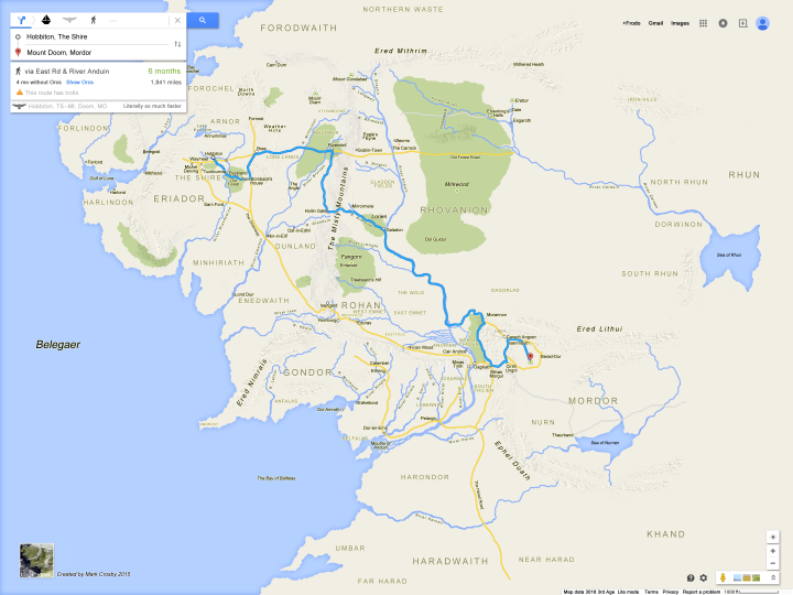
If Sam and Frodo had had this Google Map of Middle Earth, their journey would likely have been a lot easier than the one in the Lord of the Rings. Created by Mark Crosby the map has all sorts of wonderful additions.
For example:
- The estimated journey time is 6 months with Orcs or 4 months without.
- A warning that ‘This route has trolls.’
- There is an Eagle option (see my comments below)
- Instead of the Satellite view, there’s a Dragons view.
- Map data 3018, 3rd age
One thing that’s never made a whole lot of sense about the Lord of the Rings films to me is, if they had Eagles, why didn’t they just use them to fly straight to Mordor. I understand the books and films are supposed to be more about the journey, but you’d think if you’re looking to destroy the One Ring of Power, you’d want to do it as quickly and efficiently as possible.
However, after doing some research, it seems hardcore fans of the series dismiss the Eagle option as pure fantasy. They claim the flying Nazgûl would have easily killed them before they got to Mordor.
In any case, the map above is great no matter whether or not the route taken by Frodo and Sam was the most efficient or not.
For more Lord of the Rings see:
- Atlas Of Middle-Earth
- Map Of Middle Earth The Lord Of The Rings
- Movies: The Lord of the Rings: The Motion Picture Trilogy Extended Editions
- Books: The Hobbit and the Lord of the Rings
Also see: A “Satellite” Map Of Middle-Earth
Have any comments about the map above? Leave them in the comment section below:
Click To Get My 10 Best Brilliant Maps For Free:
Other popular maps.

Where’s Waldo Vs Where’s Wally: Maps Showing Which Is Used Where

The Largest Puzzle In The World Is A Giant 60,000 Piece Map

Bitcoin Map Shows Use Largely Limited To Europe & North America


British vs Mongol Empires At Their Respective Peaks: Which Was Bigger?

Jedi Knight Population Of The UK

4 Countries Divided By The Cold War

Tim Hortons Vs Starbucks Market Share & Locations In Canada

Map of Every Country Code Top Level Domain Name Extension
Jesse Brauning says
March 25, 2015 at 9:13 pm
Also, Sauron probably could have just murdered them out of the sky with magic…
anoNYMous Raven says
March 25, 2015 at 9:46 pm
How do I access the freaking map?!
Paul B. Lot says
March 26, 2015 at 2:23 pm
Why would the Eagles help?
What’s in it for them?
Gavin W. says
June 23, 2017 at 10:07 pm
In the Silimaillion, it is explained that the Eagles were placed in Middle-earth by Manwë, one of the Valar (essentially gods), to live in the mountains north of Beleriand in order to keep watch over Morgoth. Morgoth was one of the Valar who had, through jealousy and hatred, become corrupted and was effectively the source of evil in Middle Earth. Sauron was essentially Morgoth’s lieutenant. So, in helping to destroy the ring, the Eagles were fulfilling a part of their purpose – ultimately, to bring about the destruction of Morgoth.
June 26, 2017 at 12:07 pm
That third word should read “Silmarillion”. Apologies for the typo.
Bibliofilen says
March 28, 2015 at 7:00 am
Gandalf or Elrond did ask the Eagles but they didn’t want to leave their territory.
Kim Haze says
June 13, 2015 at 12:53 pm
Where is Thorin’s Hall etc.? http://dynmap.ruslotro.com/#Ered%20Luin
November 6, 2017 at 9:47 pm
Harlindon and Forlindon are the areas LOTRO call Ered Luin. During the Third Age, its forests, besides that of Mirkwood, were the largest in Middle-earth. In the latter part of the Third Age, the Dwarves settled the Blue Mountains again when Thráin II, his son Thorin Oakenshield and the Dwarven survivors of the Sack of Erebor moved from Dunland and delved a prosperous settlement there. After the War of the Ring and the defeat of Sauron, Elves continued to travel west to Lindon through the gap in the mountains by way of the Gulf of Lune, where they eventually intended to set sail on the Straight Road to the Undying Lands of Aman. After the War of the Ring it is said that many Dwarves from the east migrated back to their ancient homeland and Ered Luin was a prosperous kingdom once more.
Ermelyn PItts says
June 13, 2015 at 2:48 pm
This is AWESOME!!!
June 13, 2015 at 9:41 pm
Why is Thorin’s Hall not on the freaking map?!
Peter Arne says
January 31, 2016 at 11:56 pm
Why is it a giant static image file? Is there an actual interactive site somewhere? Where?
Daniel Copeland says
January 16, 2017 at 4:07 am
Minor plot point left out of the movies because it would have been fiddly, but which would have forestalled all this Eagle Taxi Service nonsense: Eagles cannot, in fact, carry humans (or even hobbits) all that far. The eagle that rescued Gandalf from Orthanc dropped him off in nearby Rohan, where he borrowed a horse to get to distant Rivendell. In the books the eagles talk, and they have this conversation: GANDALF: How far can you bear me? EAGLE: Many leagues, but not to the ends of the earth.
russjohnson says
December 12, 2018 at 1:50 am
Regarding the comment about why the Fellowship did not just fly on the Eagles to Mordor, that is exactly what Gandalf advises when he said “Fly, you fools!”|. Unfortunately the party was too distracted by orcs, the Balrog and seeing Gandalf fall in Moria to remember his advice the next day.
Dol Miroth says
April 20, 2023 at 12:25 am
Yes it’s slightly incorrect^^ they didn’t took the Greenway before reaching Bree. And they came to Amon Sul from the north as Aragorn also avoided the street because of things. After the weathertop they crossed the street and where in the southern bushlands. Then got back on the street at the first bridge of the next river. I think mitheitel. 😀
Leave a Reply Cancel reply
Your email address will not be published. Required fields are marked *
This site uses Akismet to reduce spam. Learn how your comment data is processed .

IMAGES
VIDEO
COMMENTS
This is a high resolution interactive map of J.R.R. Tolkien's Middle-earth. In the menu to the right you can show events, places and character movements.
Here is a sample picture of Frodo's journey towards Weathertop, each day is marked on the map. It also contains Bilbo's journey from the Hobbit, with Frodo's overlaid in brown to show differences in route and time taken.
If Sam and Frodo had had this Google Map of Middle Earth, their journey would likely have been a lot easier than the one in the Lord of the Rings. Created by Mark Crosby the map has all sorts of wonderful additions.
An atlas of 51 maps charting the journey that Frodo and his companions undertake in J.R.R.Tolkien’s epic work.
The book comprises 51 two-colour maps (a general map of Middle-earth and 50 numbered maps) at various scales, all based on the original The Lord of the Rings maps drawn by Christopher Tolkien from his father's sketches. Each map is on a right-hand page in landscape format and depicts physical features in black and contour lines in red. Routes ...
There is a fantastic book I might recommend which is part of my Tolkien Collection, it's called the 'Journeys of Frodo', forget the name of the author. It's a fantastic and very detailed book and details the entire fellowship's journey.